
Landsmeer
 flag |
 coat of arms |
| province |
|
| mayor | Dennis Straat ( VVD ; acting) |
| Seat of the municipality | Landsmeer |
|
Area - land - water |
26.5 km 2 22.52 km 2 3.98 km 2 |
| CBS code | 0415 |
| Residents | 11,485 (Jan 31, 2019) |
| Population density | 433 inhabitants / km 2 |
| Coordinates | 52 ° 28 ′ N , 4 ° 57 ′ E |
| prefix | 020, 0299 |
| Postcodes | 1121, 1127, 1451 |
| Website | Homepage of Landsmeer |
 |
|
Landsmeer ( ) is a village and a municipality in the Waterland region in the Dutch province of North Holland . The municipality has 11,485 inhabitants (as of January 31, 2019), its area covers 26.5 km², of which 3.98 km² is water.
In 1966 the parts of the municipality south of the A10 were incorporated into Amsterdam. Landsmeer is part of the “Kaderwetgebied” Regionaal Orgaan Amsterdam (abbreviation: ROA ), a supra-municipal and sometimes supra-provincial working group of 16 cities with a total of more than one million inhabitants around Amsterdam . Landsmeer lies partly in the nature reserve Het Twiske ; The municipality shares its care with Zaanstad , Oostzaan and Amsterdam.
Landsmeer entered into a municipal partnership with the North Rhine-Westphalian municipality of Lieberhausen in 1968 . When the Upper Bergisch community was dissolved during the municipal reforms and its northern part was incorporated into Gummersbach and its southern part around Wiedenest-Belmicke-Pernze after Bergneustadt , Bergneustadt continued the town twinning . A partnership with the French Châtenay-Malabry has existed since 1986 .
Districts
- Landsmeer
- The Ilp
- Purmerland
politics
Distribution of seats in the municipal council
The local elections on March 21, 2018 resulted in the following distribution of seats:
| Political party | Seats | |||
|---|---|---|---|---|
| 2006 | 2010 | 2014 | 2018 | |
| VVD | 4th | 5 | 3 | 3 |
| D66 | 1 | 2 | 4th | 3 |
| Lokaal Landsmeer | - | - | - | 3 |
| GroenLinks | 1 | 1 | - | 2 |
| Positief Landsmeer | - | 2 | 3 | 2 |
| CDA | 1 | 1 | 2 | 1 |
| PvdA | 5 | 4th | 2 | 1 |
| Lijst Maja van Campen | - | - | 1 | - |
| Community concerns | 2 | - | - | - |
| Politieke Vereniging Landsmeer | 1 | - | - | - |
| total | 15th | 15th | 15th | 15th |
Town twinning
Landsmeer maintains city partnerships with
-
 Bergneustadt , Germany , since 1968
 -
 Châtenay-Malabry , France , since 1986
Bergneustadt and Châtenay-Malabry have been linked since 1967.
photos

Restaurant and Reformed Church

Drawbridge: de Kleine Zijlbrug
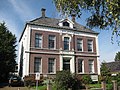
House Dorpsstraat No. 54


Daughters and sons of the church
- Sam Olij (1900–1975), boxer and collaborator
- Jan Olij (1920–1996), boxer and war criminal
- Jacob Oudkerk (* 1937), racing cyclist
- Cor Bakker (* 1961), pianist
Web links
Individual evidence
- ↑ Dennis Straat nieuwe warnemend burgemeester Landsmeer. In: Het Parool . De Persgroep Nederland , July 2, 2019, accessed on August 21, 2019 (Dutch).
- ↑ Bevolkingsontwikkeling; regio per maand . In: StatLine . Centraal Bureau voor de Statistiek (Dutch)
- ↑ Result of the local elections: 2014 2018 , accessed on May 16, 2018 (Dutch)
- ↑ Allocation of seats in the municipal council: 2006 2010 2014 2018 , accessed on May 16, 2018 (Dutch)
Aalsmeer | Alkmaar | Amstelveen | Amsterdam | Beemster | Mountains | Beverwijk | Blaricum | Bloemendaal | Castricum | Den Helder | Diemen | Drechtland | Edam-Volendam | Enkhuizen | Gooise Meren | Haarlem | Haarlemmermeer | Heemskerk | Heemstede | Heerhugowaard | Heiloo | Hilversum | Hollands Kroon | Hoorn | Huizen | Koggenland | Landsmeer | Langedijk | Laren | Medemblik | Oostzaan | Opmeer | Ouder-Amstel | Purmerend | Schagen | Stede Broec | Texel | Uitgeest | Uithoorn | Velsen | Waterland | Weesp | Wijdemeren | Wormerland | Zaanstad | Zandvoort