Ketelmeer
| Ketelmeer | ||
|---|---|---|

|
||
| Breakwater in the Ketel Sea | ||
| Geographical location | Northern Netherlands, provinces Flevoland and Overijssel | |
| Tributaries | IJssel , Vossemeer | |
| Drain | IJsselmeer | |
| Islands |
artificial: IJsseloog , Hanzeplaat, Schokkerbank |
|
| Places on the shore | Dronten , Kampen | |
| Location close to the shore | Amsterdam | |
| Data | ||
| Coordinates | 52 ° 36 ' N , 5 ° 43' E | |
|
|
||
| Altitude above sea level | 0 m | |
| surface | 35 km² | |
| length | 13 km | |
| width | 4 km | |
| volume | 84,000,000 m³ | |
| Maximum depth | 3.5 m | |
| Middle deep | 2.4 m | |
|
particularities |
|
|
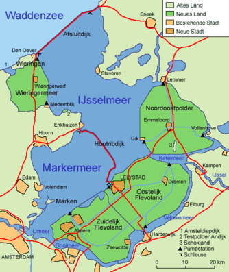
The Ketelmeer (Dutch sea - the lake) is a lake in the Netherlands that, like many other inland lakes there, was created by the separation of the former Zuiderzee from the North Sea and the subsequent poldering. It is located between the Polder Flevoland in the south and the Noordoostpolder in the north. In the west, the Ketelmeer is separated from the IJsselmeer by the Ketelbrug (bridge) , in the northeast by the bellows dam at Ramspol from the Zwarte Meer , and in the southeast by the mouth of the IJssel .
In the south it is connected to the Vossemeer , which is separated from the Drontermeer by a lock .
environmental issues
The bottom of the Ketel Sea is heavily contaminated ; the Rhine has deposited a 50 cm deep layer of sludge full of pollutants ( PCB , heavy metals ) over its IJssel estuary over the years . In order to collect this sludge, the IJsseloog island landfill was built between 1996 and 1999 in the middle of the Ketel Sea .
After the reconstruction of the lake bed, a fairway is to be dug in the Ketelmeer , which will allow ships with a draft of up to 3.50 meters to pass through. This should also make the lower course of the IJssel navigable. The excavated, unpolluted silt is to be used to fill an estuary delta of the IJssel in which the IJsselmonding nature reserve ("IJssel estuary") is to be created.


