IJsseloog
| IJsseloog | ||
|---|---|---|
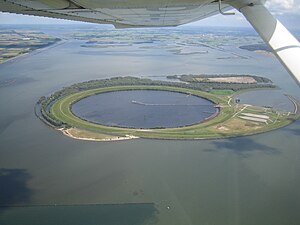
| Oblique aerial view: IJsseloog from the west | ||
| Waters | Ketelmeer | |
| Geographical location | 52 ° 36 ′ 0 ″ N , 5 ° 45 ′ 10 ″ E | |
|
|
||
| length | 1.9 km | |
| width | 1.3 km | |
| surface | 2 km² | |
| Satellite image of the Ketelmeer with IJsseloog | ||
IJsseloog ( German Ijsselauge ) is an artificial island in the Dutch inland lake Ketelmeer , which was created as a landfill for mud from the Ketelmeer. The actual landfill appears as a circular lake with a diameter of 865 to 869 meters and an area of 59 hectares in the middle of the approximately two kilometers long, egg-shaped island, which is about half as wide as the Ketel Sea itself at this point. Its name is derived from the IJssel , which flows through the Ketelmeer.
The bottom of the Ketel Sea is heavily contaminated ; the Rhine has deposited pollutants here over its IJssel estuary for years. The landfill was built between 1996 and 1999 to collect this sludge. The almost circular landfill has a depth of 34 (average) to 45 (maximum) meters and a capacity of 20 million cubic meters.
Immediately east of IJsseloog, two more islands were created as a nature and recreation area ( Hanzeplaat with an area of 30 hectares , and Schokkerbank ). Water birds like swans , geese , spoonbills , ducks and grebes inhabit these islands.
IJsseloog and the two side islands belong to the city of Dronten , specifically to the sub-area Wijk and Buurt Buitengebied Dronten .


