
Rees
| coat of arms | Germany map | |
|---|---|---|

|
Coordinates: 51 ° 46 ' N , 6 ° 24' E |
|
| Basic data | ||
| State : | North Rhine-Westphalia | |
| Administrative region : | Dusseldorf | |
| Circle : | Kleve | |
| Height : | 17 m above sea level NHN | |
| Area : | 109.86 km 2 | |
| Residents: | 21,100 (Dec. 31, 2019) | |
| Population density : | 192 inhabitants per km 2 | |
| Postal code : | 46459 | |
| Primaries : | 02851, 02857 , 02850 | |
| License plate : | KLE, GEL | |
| Community key : | 05 1 54 044 | |
| LOCODE : | DE RES | |
| City structure: | 8 districts | |
City administration address : |
Market 1 46459 Rees |
|
| Website : | ||
| Mayor : | Christoph Gerwers ( CDU ) | |
| Location of the city of Rees in the Kleve district | ||
  |
||

Rees is a city on the Lower Rhine , it is located in the northwest of the state of North Rhine-Westphalia and is a district city of the Kleve district in the administrative district of Düsseldorf . Rees is a member of the Euregio Rhine-Waal .
geography
City structure
The urban area is divided into eight municipal districts ( localities ), each of which is represented by a local councilor:
- Bees (884 inhabitants)
- Empel (468 inhabitants)
- Eating earths (500 inhabitants)
- Haffen (1,099 inhabitants)
- Haldern (approx. 5,000 inhabitants)
- More (2,319 inhabitants)
- Millingen (2,988 inhabitants)
- Rees (city center) (8,214 inhabitants)
Neighboring communities
The city of Rees borders in the north on the municipality of Oude IJsselstreek (province of Gelderland , NL ) and the city of Isselburg ( district of Borken ), in the east on the cities of Hamminkeln and Wesel and in the south on the city of Xanten (all three in the Wesel district ) and in West to the cities of Kalkar and Emmerich am Rhein (both in the Kleve district ).

| Emmerich (D) | Oude IJsselstreek (NL) | Isselburg (D) |
| Kalkar (D) |
.svg)
|
Hamminkeln (D) |
| Xanten (D) | Wesel (D) |
Location on the Rhine
The entire history of the Rees area has been in the area of influence of the Rhine river with floods, bank breaks, island formation and relocations. The drawing by the cartographer Johann Bucker from 1713 shows Rees and the surrounding area with some smaller and larger islands and sands in the Rhine (e.g. the alde Eilant , dat Reesche Grindt and the Poddeckel ), which are no longer in this form today exist. Some of the old arms of the Rhine on both banks are now largely silted up. The island of Middel Grindt , a little further down the Rhine on the other bank, now forms the foreland to the village of Hönnepel . In the area of the formerly fortified Reeschen Schantz (now a nature reserve as Reeser Schanz ), a leisure and water sports center is now being built.

Nature reserves
In the Rees urban area, around 18 percent of the area is designated as nature reserves . In total, there are fourteen areas worthy of protection, which are mainly located in the districts around the city center. The nature reserves are predominantly branches of the Old Rhine and their adjacent meadows, which have emerged over the centuries as a result of the change in the course of the Rhine on the Lower Rhine. Every year 200,000 arctic geese overwinter in the meadows and floodplains around Rees and on the Lower Rhine. In addition, the protected areas ( e.g. Bienener Altrhein, Millinger Meer and Hurler Meer , Grietherorter Altrhein and Hetter-Millinger Bruch ) are of particular importance nationwide for rare breeding birds such as the black tern , little ringed plover , godwit , redshank , shoveler and teal .
history
Early history
The first evidence of human life in the Rees city area was discovered in 1961 during construction work on the motorway (A 3) on the Colettenberg / Wittenhorst near Haldern . Remains of grave goods (broken cups, daggers) from the end of the Neolithic period (4000 years ago) were found. In the course of the excavations carried out there, the remains of a settlement from the Hallstatt period (800 to 450 BC) were also found.
middle Ages
Around 500–800 AD , a Frankish settlement was built on an elevated point, a “ ward ” . The name Rees is said to go back to "Rys" = rice = Rees (willow trees with reeds).
From 695 to 739 the Lower Rhine was Christianized by the Anglo-Saxon monk Willibrord , and a first church was built in Rees around 700. Aspel Castle was first mentioned in a document around 1000 . Probably around 1040 Irmgard von Aspel had a new church built over the graves of her parents in the now fortified Rees and founded a canons there , which soon also included a Latin school . On July 14, 1228, the Archbishop of Cologne elevated the settlement with around 150 buildings and 600 residents to the status of a city , making Rees the oldest city on the Lower Rhine.
The construction of the city wall began in 1289/90 and was completed around 1350. In 1392 Rees was left by the Archbishop of Cologne, Friedrich von Saar Werden , against cession by the city of Linn , the county or the later Duchy of Kleve . The economic boom enabled the construction of further fortifications and the Gothic town hall around 1450.
Modern times

In 1549 the magistrate expelled the Jews from the city. In 1571 a Protestant congregation was first mentioned in Rees. During the Spanish-Dutch War ( Eighty Years War ), a Spanish mercenary army under Francisco de Mendoza took the city in 1598 . After the death of the last Duke of Kleve, Johann Wilhelm (1609), Rees fell to Brandenburg-Prussia in 1614 . From 1616 to 1625 the Dutch built the large, extensive Rees fortress according to the Dutch system. On June 7, 1672 the city was told by the French under Marshal Turenne and 1674 by the Brandenburgers , which on the fortifications razed , captured. Ferdinand von Braunschweig , who was in Prussian service during the Seven Years' War , had a ship bridge built over the Rhine in 1758 and was victorious in a battle against the French under Marshal Contades .
By 1800 Rees had about 3,000 residents. In 1806 the remainder of the previously Prussian Duchy of Kleve on the right bank of the Rhine came to the Grand Duchy of Berg , to which Rees belonged until 1813. After the introduction of new administrative structures based on the French model in the Grand Duchy (1808), Rees was the seat of a canton that belonged to the Arrondissement of Essen in the department of the Rhine . After Napoleon's defeat in the Battle of Leipzig , the former Prussian areas on the right bank of the Rhine came under Prussian administration again at the end of 1813 and were finally confirmed as Prussian property at the Congress of Vienna (1815). In 1816 Rees became the seat of the new Rees County . In 1842 the seat of the district was moved to Wesel . The name of the district was retained ("District Rees, seat in Wesel"). In 1856 the railway line Oberhausen - Arnheim of the Cologne-Minden Railway was opened.
20th century
At the beginning of the 20th century, Rees had 4,096 inhabitants, the majority of whom were Roman Catholic. 330 were Protestant and 52 were Jews .
During the time of National Socialism , Jewish citizens were persecuted, deported and murdered in Rees . The city was almost completely destroyed in a major air raid on February 16, 1945 as part of Operation Veritable . In Rees-Groin there was a forced labor camp run by the National Socialists from November 1944 to March 25, 1945 with the name "Ausländerlager Groin, Röhrig construction section, Heinze unit" , named after the two camp managers. 5000 prisoners from different countries, more than half of them from the Netherlands, had to carry out entrenchment work in Rees. The prisoners were housed under inhumane conditions in a brick factory in the Rees-Groin district or in halls in the Bienen district. About 10 percent of the prisoners did not survive the camp.
Incorporation in 1969 and 1975
July 1, 1969 as part of the were the first municipal restructuring program until then independent municipalities Bergswick , Esse gestures , Reesereyland , Reeserward and Speldrop the former Office Rees country and the communities of bees , Grietherbusch and Grietherort incorporated the former Office Vrasselt in the city Rees. Rees now has 8,100 residents.
On January 1, 1975, as part of the second reorganization program, the municipalities of Empel and Millingen of the former Office Millingen and the municipalities of Groin , Haffen-Mehr (partially), Haldern (partially) and Heeren-Herken of the former Office of Haldern were merged with the city of Rees. As a result, the city's population rises to 17,300 people. At the same time, the Rees district was dissolved and the former western district area was merged with the former Geldern and Kleve districts and with parts of the Moers district to form the new Kleve district on the Lower Rhine . Rees has been a county town in that county ever since.
Population development
The following information refers to the current area of the city of Rees.

- 1975: 16,665 inhabitants
- 1980: 17,453 inhabitants
- 1985: 17,794 inhabitants
- 1990: 18,616 inhabitants
- 1995: 20,010 inhabitants
- 2000: 21,618 inhabitants
- 2005: 22,559 inhabitants
- 2010: 22,267 inhabitants
- 2015: 21,349 inhabitants
- 2016: 21,140 inhabitants
- 2017: 21,137 inhabitants
politics
City council
Since the last local election on May 25, 2014 , the city council has the following composition:
| CDU | 49.7% | 17 seats |
| SPD | 29.4% | 10 seats |
| GREEN | 15.2% | 5 seats |
| FDP | 5.7% | 2 seats |
The next local election will take place on September 13, 2020.
mayor
Mayor of the city of Rees has been Christoph Gerwers (CDU) since 2009 . He was re-elected in 2015 with 66.6% of the vote. His opponent was Karl van Uem (SPD, 33.4%). The turnout was 44.23%.
The next mayoral election will take place in 2020.
Coat of arms, seal, banner and logo
The city of Rees was last given a coat of arms, a seal and a flag (banner) in 1965. The city also has a logo.
coat of arms
Coat of arms until 1965

banner

logo


coat of arms
Blazon : "A silver (white) key in red, the beard of which points to the right." Meaning: The key, whose beard has the shape of a cross, refers to the Apostle Peter , patron of the Archdiocese of Cologne .
seal
“The official seal is identical in form, size and content to the seal printed in these main statutes.” Unfortunately, the seal is missing.
banner
White background with red edge stripes, in the middle field - a little upwards - the city coat of arms of Rees: red background with black edge of the coat of arms, here white key with the beard pointing to the left, black contoured. The correct description must be: "From red to white to red in a ratio of 1: 8: 1, striped lengthways, slightly above the middle of the white strip of the city's coat of arms."
Culture and sights
In Rees there is a Rhine promenade with numerous cafés and the famous bronze statue "Dialogue". The "Rhinkieker" is a sculpture created by the sculptor and artist Dieter von Levetzow , which has found its place on the market square in Rees. There she looks through a side street at the Rhine flowing by. Shown is an original typical of Rees, one of the numerous citizens of Rees and the Rhine, who meet there to chat at the edge of the market and take the shipping "under the microscope". Visitors are particularly frequent from the neighboring Netherlands, the nearby Münsterland and the Ruhr area. The city can be reached from the Ruhr area in just under 30 minutes via the A3 motorway (towards Arnhem). Rhine tours start from the jetty (e.g. to the nearby Netherlands). There are good conditions for cyclists and inline skaters on cycle paths along the Rhine.
The city's Koenraad-Bosman Museum offers changing exhibitions on city history and art. Under the museum building there is an accessible casemate for light artillery , built around 1500 . There are many pumps and small wells in the town center. These were restored by the city administration. Every year the so-called pump fair takes place in the city center in memory of the tradition of washerwomen at the public fountain.
The bronze statue "Dialogue" by the artist Jürgen Ebert from Bocholt , placed on the Rhine promenade, is a particularly popular photo opportunity for tourists and residents. The writer HD von der Strauchburg tells how the two girls, Laura and Yasmin, who had become bronze, came to the Rees Rhine promenade in his fairy tale from 2004, "The Bronze Girls".
In the sculpture park near the Rhine, established in 2003 , artists from Germany and the Netherlands are given the opportunity to present their works. Since June 2008 there has also been a floor sundial in the sculpture park, on which every visitor can act as a pointer himself. In addition, the city of sculptures enjoys numerous objects by various artists in the city center. These can all be discovered on a tour. The planet trail that was built between Rees and the village Haffen-More, is about eight kilometers in length to scale the planets of our solar system . In the community center will find changing events in the field of theater, concerts, comedy and children's theater instead. For several years now, the city has also been organizing the so-called "Reeser Adventure Summer" between May and October. These are various events from bike tours to an open-air cinema. Finally, the nationally known open-air festival Haldern Pop takes place in the Haldern district.
Buildings
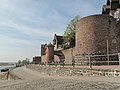
City fortifications
- The city fortifications near the Rhine are worth seeing . Various casemates have been restored and have been open to the public since 2004. Particularly interesting, although not directly accessible to visitors, is the city's Jewish cemetery , which - as a historical feature - neither inside the city walls (which was not allowed at the time) nor outside them (which would have given up the cemetery in cases of flooding or siege) but was built on the city wall.
Parish Church of St. Vincentius
- The Catholic parish church of St. Vincentius in Rees-Mehr began in the 11th century on the site of an existing chapel with the construction of a central nave , to which an apse adjoins in the east . Shortly after 1200, the Romanesque construction of the three-storey tower and the "stair tower" were carried out. With the complete redesign in 1447 in the Gothic style, the new aisle was also created . The belfry contained the bells cast in 1783 and the three bells cast in the churchyard in 1842. Three of these bells were confiscated in 1942 for armament purposes. The church was largely destroyed by artillery fire during World War II and rebuilt between 1951 and 1954. In 1957 she received four new bells. With the completion of a new central nave vault, it received its current appearance.
- The new organ with 17 registers was installed in 1988 by the Dutch organ builder Verschueren-Heythuysen .
Nobility seats
- There are several former aristocratic residences in the Rees city area. These include the moated castles Huth and Bellinghoven and the ruin of the documentary mentioned in the 13th century house Empel . The late medieval Battenberg Tower in Haldern is one of them, as is the former knight's seat at Haus Groin . There are no remains of the former Sonsfeld Castle , today the so-called Blue House stands on its site . On the other hand, Haus Aspel is still completely preserved and is used today as a monastery by the religious order of the Daughters of the Holy Cross .

Entrance to the Jewish cemetery on the city wall

At the former city wall
Old customs tower

Mill tower

Sculpture park
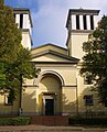
Catholic parish church St. Maria Himmelfahrt
.jpg)


education
The urban high school in Aspel goes back to the girls' boarding school Haus Aspel, which was founded in 1851 and which was converted into a high school in 1950 and was given municipal sponsorship in 1971. In 1986 the grammar school moved into a new building in the school center on Westring. The city library , founded in 1952 , is located in a listed building on the market square. In addition to the irregular readings, it has organized the book and art market on the Rhine promenade every year since 2002 . Since 2003 she has been organizing the Tom Sawyer Prize , a Germany-wide school writing competition that is announced every two years by the city of Rees.
Sports
In the city, numerous well-known teams have already made guest appearances at a training camp on the SV Rees sports field on Ebentalstrasse, which consists of four grass pitches (two of which are floodlit). Alemannia Aachen prepared for the cup final here, the national team of Cameroon and numerous other top international teams have already made guest appearances in Rees and used the excellent training opportunities to prepare for their respective sporting challenges.
The Reeser Meer running park , southeast of downtown Rees, was opened in 2012 and connects the districts of Rees, Haffen, Mehr and Haldern. The project was funded as part of the "LEADER" focus of the "NRW Rural Areas 2007-2013" program. The running park covers a distance of 10 km, which can be used by runners , walkers , hikers and cyclists alike . The running department of the SV Haldern club organizes its fun run "Around the Reeser Mehr" in June, which now has around 1,000 participants.
Economy and Infrastructure
economy
Rees has long been a center of the tobacco industry; The Oldenkott company (1838–1992, tobacco, cigarette and pipe factory) and the Dobbelmann tobacco and pipe factory (1928–1964) should be mentioned in particular . Today the monument “Der Kiepenkerl” on the Flora in Rees still reminds of the Oldenkott company. The Oldenkott tobacco warehouse is now a residential and commercial building. The company had a connection to the Baumberbahn (Münster - Empel-Rees). There is also no longer a trouser sewing shop on Melatenweg today.
science
A research station of the University of Cologne is located in Rees-Grietherbusch . She examines u. a. the fish populations in the Rhine and adjacent waters as well as the ecology of the floodplains and the population ecology of birds.
media
Two daily newspapers with local editorial offices appear in Rees, the Rheinische Post and the Neue Rhein Zeitung . Two advertising papers appear weekly with local information, the Emmerich-Rees city gazette (Wednesdays and Sundays) and the Niederrhein-Nachrichten (Saturdays).
traffic
Rail and bus transport
Empel-Rees train station is about four kilometers northeast of the city center on the Oberhausen – Arnhem railway line . It is served by the RE 19 ( Rhein-IJssel-Express ) from Arnhem via Emmerich , Wesel , Oberhausen and Duisburg to Düsseldorf in local rail passenger transport (SPNV) .
There are also two more stations on the Holland route, the “Haldern (Rheinl)” and “ Millingen (b Rees) ” stops .
Between May 25, 1914 and December 31, 1966, the Wesel – Rees – Emmerich railway operated here, and between February 28, 1915 and December 31, 1966, the Rees – Empel railway operated here .
The Empel-Rees train station and the Millingen stop are connected to the city center as well as Isselburg and Bocholt by the 61 city bus . Line 87 also goes to the city center. Line 95 connects the Haldern stop with the city center and Bocholt.
The tariff of the Verkehrsverbund Rhein-Ruhr (VRR) applies to all local public transport and the NRW tariff applies to all tariff areas .
Road traffic
Through the motorway junction 4 / Rees of the federal motorway 3 ( E 35 ) about 7 km north of the city, Rees is connected to the motorway network. In the north-west of the city area, federal highway 8 and federal highway 67 intersect .

Waterway
The Rhine flows in the south of the urban area . For pedestrians and cyclists they run from Easter to October
- the Rhine ferry "Räässer Pöntje" from Rees to Reeserschanz in Kalkar -Niedermörmter near Rheinstrom-km 838 and
- the Rhine ferry “Inseltreue” from Grietherort to Kalkar- Grieth near Rheinstrom-km 845.
The river , known here as the Lower Rhine , can be crossed by car on federal road 67 ( Rhine bridge Rees-Kalkar ) in the west of the city.
Personalities
- Irmgard von Aspel (before 1013-1082 / 1089), Saint Irmgard / Irmgardis (from Süchteln / from Cologne)
- Konrad Heresbach (1496–1576), German humanist
- Jakobus Greselius (1483–1552), professor at the University of Cologne and Canon of Rees
- Rijklof van Goens (1619–1682), Governor of Ceylon and Governor General of the Dutch East Indies
- Samuel Nethenus (1628–1707), theologian
- Johann Jakob von Collas (1721–1792), captain and major, landlord in Haldern
- Bernhard Quante (1812–1875), choirmaster, clergyman and music teacher, rector in Rees from 1840 to 1851
- Robert Scholten (1831–1910), historian
- Wilhelm Carl Ernst Isselmann (1885–1916), painter
- Piet Leysing (1885–1933), “Lower Rhine painter” from the Düsseldorf School
- Gerhard Storm (1888–1942), martyr of the Catholic Church
- Bentivolius Heinrich Marxen (1911–1995), German religious and escape helper
- Karl Leisner (1915–1945), martyr of the Catholic Church, who died as a result of imprisonment in a concentration camp
- Eduard Lensing (1920–2004), farmer and politician (CDU), Member of the Bundestag
- Hans Booms (1924–2007), archivist and head of the Federal Archives
- Gustav Schaeling (1928–2015), banker and entrepreneur
- Wilhelm Buckermann (1934–2004), mayor, holder of the Federal Cross of Merit
- Vlado Stenzel (* 1934), German national handball coach
- Astrid Karuna Feuser (* 1951), artist
- Franz-Josef Tenhagen (* 1952), former soccer player and coach
- Hans Jürgen Prömel (* 1953), mathematician, President of the Technical University of Darmstadt ( TU Darmstadt )
- Gerd-Heinz Stevens (* 1957), musicologist, composer and church musician
- Werner Buttgereit (* 1959), former soccer player
- Brigitta Schütt (* 1963), geographer and university professor at the Free University of Berlin
- Dirk Vallée (1965–2017), civil engineer and university professor for urban construction and urban transport at RWTH Aachen University
- Georg Maria Roers (* 1965), theologian and priest
- Norvin Leineweber (* 1966), sculptor and graphic artist
- Michael Scholten (* 1971), journalist and author
- Bodo Wißen (* 1974), politician (SPD), MdL
- Mirko Boland (* 1987), German football player ( Eintracht Braunschweig )
- Vanessa Martini (* 1989), German soccer player
literature
- Erich Liesegang: Law and Constitution of Rees . (= WZGK, supplement 6), Trier 1890
- Paul Clemen (ed.): The art monuments of the Rees district (= The art monuments of the Rhine province . Volume 2, section 1). L. Schwann, Düsseldorf 1892, p. 61 ( online ).
- Felix Rütten : Rees on the Rhine. The medieval city and its foundations. Festschrift for the 700th anniversary of the city (July 14th to 16th, 1928) . Rees 1928
- Josef Esser, Ressa uber. The fertile Rees. 725 years of the city of Rees , in: Heimatkalender Kreis Rees 1955, Emmerich 1954, pp. 99-107.
- Klaus Flink: Rees, Xanten and Geldern. Forms of urban and territorial development on the Lower Rhine 1 . Kleve 1981
- Jan Krist: The Hell of Rees. Memories of a forced labor camp . From the Dutch by Erwin and Marie-Elisabeth Rehn, Labhard, 2nd edition, Konstanz 1989, ISBN 3-926937-19-X
- Dieter Kastner: Rees - history of the city at a glance . In: Koenraad Bosman Municipal Museum. Museum of Art and City History Rees , Rees 1997, pp. 63–98.
- Heike Hawicks: On the economic importance of the veneration of saints for the construction of Gothic sacred buildings on the Lower Rhine. The example of Viktortracht and Viktordom in Xanten in the context of procession and church building in Rees and Cologne . In: Dieter Geuenich (Ed.): Adoration of saints and pilgrimages on the Lower Rhine (= series of publications by the Lower Rhine Academy, Volume 6). Essen 2004, pp. 50–70
Web links
Individual evidence
- ↑ Population of the municipalities of North Rhine-Westphalia on December 31, 2019 - update of the population based on the census of May 9, 2011. State Office for Information and Technology North Rhine-Westphalia (IT.NRW), accessed on June 17, 2020 . ( Help on this )
- ↑ Main statute of the city of Rees (PDF; 34 kB) § 3 municipal districts
- ↑ Population figures from 2009
- ↑ Erich Wisplinghoff, explanations from 1984 on: Johann Bucker, map of the Rhine from Duisburg to Arnhem from 1713, publisher: North Rhine-Westphalian State Archives, Düsseldorf 1984, pages 5 to 10
- ↑ The nature reserves are described on the site of the nature reserve center in Kleve.
- ↑ Maps and catalogs of measures are shown on the district's website
- ↑ Information on this, see the website "Experience nature NRW" [1]
- ^ SH Hinz: Excavations on the Wittenhorst in Haldern , in: Heimatkalender Landkreis Rees 1963, Rheinberg 1962, pp. 63–66.
- ↑ a b c Friedrich von Restorff : Topographical-Statistical Description of the Royal Prussian Rhine Province , Nicolai, Berlin and Stettin 1830, p. 458 ( Google Books )
- ^ Wilhelm Keil: Neumanns Orts- und Verkehrslexikon , vol. 2, p. 875. Leipzig 1905
- ↑ On the Jewish community of Rees see: Reuter, Ursula: Jüdische Gemeinde vom early 19th to the beginning of the 21st century . (= Historical Atlas of the Rhineland VIII.8.) Bonn 2007 and Pracht-Jörns, Elfi: Jewish cultural heritage in North Rhine-Westphalia, part II: Düsseldorf administrative region . (= Contributions to the architectural and art monuments in the Rhineland, February 34) pp. 355–360, Cologne 2000.
- ↑ see for example the list of stumbling blocks in Rees
- ↑ Bachelor thesis on the warehouse in Rees by Lukas Bergmann (2014)
- ↑ Martin Bünermann: The communities of the first reorganization program in North Rhine-Westphalia . Deutscher Gemeindeverlag, Cologne 1970, p. 103 .
- ↑ a b Chronicle of the City of Rees. City of Rees, accessed July 5, 2019 .
- ^ Federal Statistical Office (ed.): Historical municipality directory for the Federal Republic of Germany. Name, border and key number changes in municipalities, counties and administrative districts from May 27, 1970 to December 31, 1982 . W. Kohlhammer, Stuttgart / Mainz 1983, ISBN 3-17-003263-1 , p. 297 .
- ↑ Population of all municipalities in North Rhine-Westphalia from December 31, 1962 at the end of each year according to the current territorial status
- ↑ a b Election results for the 2014 municipal elections ( memento of the original from March 4, 2016 in the Internet Archive ) Info: The archive link was inserted automatically and has not yet been checked. Please check the original and archive link according to the instructions and then remove this notice. Municipal data center Niederrhein
- ↑ Mayoral election results 2015 ( Memento of the original from September 17, 2015 in the web archive archive.today ) Info: The archive link was inserted automatically and has not yet been checked. Please check the original and archive link according to the instructions and then remove this notice. Municipal data center Niederrhein
- ↑ rees-erleben.de Description of the coat of arms of the city of Rees
- ↑ Main statute of the city of Rees (PDF; 38 kB) rees-erleben.de. Retrieved September 25, 2013.
- ↑ Email from Birgit Fischer, Stadt Rees Department - Central Services
- ↑ Monuments in Rees, churches and chapels (PDF; 4.6 MB)
- ↑ Organ building company ( Memento of the original from October 2, 2009 in the Internet Archive ) Info: The archive link was inserted automatically and has not yet been checked. Please check the original and archive link according to the instructions and then remove this notice.
- ↑ S. website of the running park
- ↑ Page of the Halderner Volkslauf "Around the Reeser Meer"
- ↑ Research station Grietherbusch mathnat.uni-koeln.de ( page can no longer be accessed , search in web archives ) Info: The link was automatically marked as defective. Please check the link according to the instructions and then remove this notice.
- ↑ VRR press release of November 25, 2011

Bedburg-Hau | Emmerich am Rhein | Geldern | Goch | Issum | Kalkar | Kerken | Kevelaer | Kleve | Kranenburg | Rees | Rheurdt | Straelen | Uedem | Wachtendonk | Weeze

Excavation lakes Lohrwardt and Reckerfeld | Old Rhine Reeser-Eyland | Aspeler-Narrow Sea | Bellinghover Sea | Bienener Altrhein, Millinger Meer and Hurler Meer | Empeler Meer | Grietherorter Altrhein | Dornick Harbor | Haffensche Landwehr – Sonsfeldsche Weiden | Hetter-Millinger break | Pretty Grändort | Long run | Sonsfeldsches Bruch, Hagener Meer and dune | Transitional moor in the Wittenhorster Heide