
Grieth


Grieth am Rhein is a district of the city of Kalkar on the lower left Lower Rhine . It is located directly on the Rhine, around 6 km north of the city center of Kalkar. On December 31, 2018, the place had 823 inhabitants.
geography
During the last millennium, the course of the Rhine near Grieth has repeatedly changed.
Accordingly, in the middle of the 13th century, the Rhine did not flow east of Grieth in a south-north direction past Grieth as it does today, but instead passed Grieth northwards from the east. It then formed a loop of the river that continued to expand to the northeast over the next 300 years or so. After all, it ran where the Bienen Old Rhine is today. The area of the village of Grietherort , which today lies opposite Grieth on the right bank of the Rhine, was connected to Grieth by a land bridge at that time . A peninsula formed around which the Rhine flowed in a wide arc - until the Rhine broke through the increasingly narrow land bridge between Grieth and Grietherort during a flood in the second half of the 16th century. What remained of these relocations of the Rhine are the arms of the Old Rhine , which characterize the landscape, especially on the right bank of the Rhine.
Downstream of Grieth, humans intervened in the 19th century to straighten a loop that had formed between Grieth and the village of Dornick on the right bank of the Rhine. In 1819 the Prussian authorities began work on the “Griether Durchstich”.
In 1832 the first Rhine barges drove through the new river bed. The dike at Grieth was last renovated around 2018-19.
history
The history of Grieth, whose name is derived from “ Gries ” or “ semolina ”, which means sand or gravel , is shaped by its location on the Rhine .
Grieth was developed into a fortified port and trading center by the Klever Counts in the 13th century. The Klever needed their own city on the Rhine in order to be able to benefit from shipping. The city of Rees , only about 7 kilometers upstream, was under the rule of the Electorate of Cologne . 1254 received Grieth from Count Dietrich VI. von Kleve city rights , 1472 customs and stacking rights . In 1540 Grieth also became a member of the Hanseatic League of Cities .
Until the 20th century, the Rhine offered many people from Griether employment opportunities, especially as boatmen and fishermen. In the river were among other eels but also salmon and Salme caught. Second, the offering before the advent of steamships , the towing earning potential. Horses pulled barges or, if the wind was too weak, sailing ships on the towpath ("Linnepad") upstream. The Griether provided the horses and found work as towers and horse drivers. Later, many of the Griether were inland navigation operators, also on small provision boats to supply passing ships with goods for daily use.
On July 1, 1969 , Grieth was incorporated into Kalkar.
Grieth has been affected by rural exodus in recent years: the former six pubs ceased operations, as did butchers, bakers and a snack bar. As part of a pilot project, the Rhein-Waal University of Applied Sciences asked many Griether what they would like for the future of their place. In July 2016, a cooperative -run shop for daily basic supplies was opened, the Griether Hanselädchen . The majority of the residents of Grieth participate in the cooperative form of society.
On May 10, 2016 was - initiated by the organizing team for the district or state competition " Our village has a future " - unanimously adopted by the Committee on Culture and Tourism of the City of Kalkar that the city (part) name officially "Grieth am Rhein " will be changed.
Site and sights
Until a few years ago, the building was kept within the medieval city limits, where one was largely safe from the flooding of the Rhine. However, when the water level was particularly high, the Rhine repeatedly penetrated the streets of Grieth.
Their course has hardly changed in the last few centuries. The silhouette of Grieth is characterized by the late Gothic three-aisled parish church of St. Peter and Paul from the 15th century . It stands - separated by a row of houses - on the market square. The unity of church, market square and densely built-up streets and alleys give Grieth its small-town character.
One of the architectural monuments in Grieth is the Grieth House , which is located on the northern edge of the city and was first mentioned in 1371 . The building, which originally also served for defense purposes, has been converted into a stately neo-Gothic building. The listed parish church of St. Peter and Paul is also worth mentioning .
Signs of Grieth's connection with the Rhine are the flag-adorned ship mast of the Grieth Schifferverein and the stele-like sculpture “Steinboot” by the Kalkar sculptor Christoph Wilmsen-Wiegmann erected in the foreland on the Rhine . On its top it carries a stylized ship moving upstream. During floods, the Rhine often flows around it.
In the local history museum Grieth on the market square, equipment and tools from basket weavers, fishermen and Rhine boatmen as well as everyday objects are shown. Complemented by pictures and photos, they give an impression of the past life in Grieth.
One of the last Rhenish eel chokers was lying on the banks of the Rhine . With the successor ship Anita II, the fisherman Rudi Hell also operates fish monitoring on behalf of scientific institutions. In 2010, in collaboration with a research station on the other side of the Rhine, in Grietherbusch , he detected young allis shad migrating in the Rhine for the first time in over 70 years . These were released as part of a European project to reintroduce allis shad in the Rhine system in Cologne, in the Sieg and on the Upper Rhine.
In summer there is the possibility to take the ferry "Inseltreue" to Grietherort by bike. The nature reserve Deichvorland bei Grieth is located near Grieth .
Personalities
The meteorologist Wilhelm Jacob van Bebber was born in Grieth in 1841.
Picture gallery
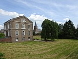
Schuldamm 4 and church

Milk cans in front of the former dairy

Limmerstrasse
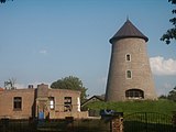
Griether Mill


literature
- Helmut Rotthauwe called Löns: Precious Kalkar. published by the city of Kalkar. Rheinland-Verlag, Brauweiler Abbey, Pulheim 1980, ISBN 3-7927-0558-3 , pp. 316-319.
- Günther J. Bergmann: Kalkar - the city guide for the center and the districts. With photos by Bernd Mörsen and maps and drawings by Karl-Heinz Rottmann. Mercator Verlag, Duisburg 2002, ISBN 3-87463-337-3 .
- Alois Puyn: Calcar, you small town on the Lower Rhine - pictures from the year 1868–1945. Völckersche Buchdruckerei and Buchhandlung Goch, Kalkar 1980, pp. 132-137.
- Robert Scholten : Contributions to the history of Wissel and Grieth and to the genealogy of the Lower Rhine families , Kleve 1889.
proof
- ↑ City portrait. City of Kalkar, accessed October 27, 2019 .
- ↑ Julius Leithäuser: Bergische place names. Verlag Buchdruckerei A. Martini, Elberfeld, 1901, p. 31.
- ^ City and club portal of the Hanseatic city of Grieth: Grieth - the story. ( Memento from August 4, 2012 in the web archive archive.today )
- ↑ Martin Bünermann: The communities of the first reorganization program in North Rhine-Westphalia . Deutscher Gemeindeverlag, Cologne 1970, p. 79 .
- ↑ Kalkar-Grieth: Hanselädchen is opened , rp-online.de, July 8, accessed on July 31, 2016.
- ^ Request by the organization team "Our village has a future" to add the name of the city . City of Kalkar. May 10, 2016. Retrieved April 25, 2019.
- ↑ University of Cologne, Research Station Grietherbusch ( page no longer available , search in web archives )
- ↑ Wikinews, Significant success for allis shad in the Rhine Significant success for EU project "Allis shad in the Rhine"
- ↑ State Office for Nature, Environment and Consumer Protection, Life Project Maifisch lanuv.nrw.de
- ↑ Poller Maigeloog, Fang Grieth, press pollermaigeloog.de
Web links
- City and club portal of the Hanseatic city of Grieth
- Literature by and about Grieth in the catalog of the German National Library
Coordinates: 51 ° 47 ′ 14 " N , 6 ° 18 ′ 51" E
Altkalkar | Appeldorn | Bylerward | Emmericher Eyland | Grieth | Hanselaer | Hönnepel | Kalkar | Turnaround | Neulouisendorf | Niedermörmter | Wissel | Wisselward