
Emmericher Eyland
|
Emmericher Eyland
City of Kalkar
|
||
|---|---|---|
.png) |
||
| Height : | 11-19 m above sea level NN | |
| Area : | 8.54 km² | |
| Residents : | 113 (December 31, 2018) | |
| Population density : | 13 inhabitants / km² | |
| Incorporation : | 1st July 1969 | |
| Postal code : | 47546 | |
| Area code : | 02824 | |
Location of Emmericher Eyland in North Rhine-Westphalia |
||

Emmericher Eyland is a district of the Lower Rhine city of Kalkar in North Rhine-Westphalia . The settlement has 113 inhabitants and, together with the neighboring villages of Bylerward and Wisselward, is one of the most sparsely populated parts of the urban area.
geography
Emmericher Eyland is located on the left bank of the Rhine , about 4 km from Emmerich and 10 km from Kleve . Neighboring villages are Huisberden , Warbeyen , Grieth and Wissel . The Kalflack river runs west of the village and flows into the Rhine opposite Emmerich. From 1945 until the municipal reorganization on July 1, 1969, the predominantly agricultural village belonged to the Griethausen Office as an independent municipality .
| Griethausen | Emmerich | Dornick |
| Warbeyen |
.svg)
|
Grieth |
| Huisberden | Till-Moyland | Wissel |
landscape
The area consists mostly of pasture for dairy cattle and poultry and arable land for beet , cabbage and corn cultivation . Most older farms around, some farmhouses dating from the 19th century in neo-Gothic style , were on mounds built because the area before increasing the Rhine dike floodplain was the Rhine. The center of Emmericher Eyland was spared from flooding because it is a little higher than the rest.
There are a few farms , residential houses and commercial buildings in the open countryside . The picturesque landscape serves as a backdrop for bike , motorcycle and vintage car races in spring and summer . By sand mining in the 1970s and 2000s two years lakes emerged.
There is a chapel on Emmericher Strasse in memory of the war dead. In front of the chapel there are four graves of young soldiers who drove their vehicles to a land mine in the last days of World War II . In the center of the little developed place is the former building of the goods cooperative . The former school building is now considered a practice room hunting horns - marching band used. There is also the fire station of the volunteer fire brigade . The population is predominantly Catholic . There are also some rural traditions, such as putting up a maypole .
Various plans (floodplain, glider airfield)
A few years ago, the authorities were planning to designate the polder area around Emmericher Eyland and Bylerward as a floodplain again . This led to protests by the population, mostly from larger farms that had previously borne the cost of dike reinforcement along the Rhine for decades. Up to now there has also been successful opposition to further plans to build a new glider airfield .
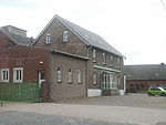
Building of the former goods cooperative

Signposts to Kleve and Emmerich
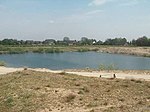
The younger of the two quarry ponds
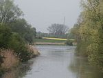
The Kalflack river seen from a bridge


Web links
- Official website of the city of Kalkar to Emmericher Eyland
- Emmericher Eyland (private website about Emmericher Eyland)
- The Bylerward dike
Individual evidence
- ↑ Topographical Information Management, Cologne District Government, Department GEObasis NRW ( Notes )
- ↑ a b city portrait. City of Kalkar, accessed October 27, 2019 .
- ^ Office Appeldorn in GenWiki , Verein für Computergenealogie eV, Erkrath, accessed on March 26, 2015
Altkalkar | Appeldorn | Bylerward | Emmericher Eyland | Grieth | Hanselaer | Hönnepel | Kalkar | Turnaround | Neulouisendorf | Niedermörmter | Wissel | Wisselward