
Wissel
|
Wissel
City of Kalkar
Coordinates: 51 ° 46 ′ 19 ″ N , 6 ° 17 ′ 17 ″ E
|
|
|---|---|
| Height : | 17 m |
| Residents : | 2061 (December 31, 2018) |
| Incorporation : | 1st July 1969 |
_(8).JPG)


Wissel is a district of the city of Kalkar on the lower left of the Lower Rhine . It is located around five kilometers north of the city center of Kalkar in the Rhine lowlands. At the end of 2018 it had 2,061 inhabitants.
Meaning of the place name
The spelling “Wisceloh” has been handed down from the 12th century. Wisch means meadow, damp lowland. Loh means bush or cleared clearing in the forest. In the 14th century the place name changed to Wissel.
history
middle Ages
A fragment of a sword from around 500 AD was recovered from a gravel pit east of Wissel. Such a large number of finds from the 8th to 12th centuries come from this gravel pit that D. von Detten suspects the location of the original settlement here, which largely slipped into the Rhine during a catastrophe and resulted in a relocation from Wissel to its present one Location forced.
Wissel was first mentioned in a document in 1070, and in 1167 the canons' monastery and today's Romanesque church of Wissel were first mentioned in a document. A chronicle dedicated to Duke Johann I of Kleve says that the canons' monastery was founded around the year 825, allegedly by Count Eberhard von Kleve and his wife Berta, a noble woman from the tribe of Charlemagne. Hellmut Rotthauwe points out, however, that this is considered by historians to be an "invention of the Klevian court historiography of the 15th century". Dieter Kastner also thinks that Count Eberhard belongs to "the legend".
The area around Wissel belonged to the Counts of Kleve in the Middle Ages . They built a castle in the Rhine lowlands between the Kalflack , a small river in the west of the lowland, and the Rhine to protect and manage their lands. It was inhabited by the Lords of Wischele, the Count of Cleves lehnspflichtig were. In 1115 the castle was defeated by the Archbishop of Cologne Friedrich I von Schwarzenburg in the war against the German Emperor Heinrich V , on whose side Count Dietrich III from Kleve was. had put, destroyed. Hellmut Rotthauwe suspects that the Counts of Kleve then contented themselves with establishing a canons' monastery in Wissel because they built their new castle in Grieth , closer to the Rhine.
The Wissel collegiate chapter consisted of the provost , the dean , the scholaster and eleven, later twelve, canons. The canons lived in their own houses that stood around the walled square church square. The canons were an order-like community, but they also had secular duties. They managed the surrounding lands and farms and lived from the income they had earned. With the secularization under Napoleon , the monastery was abolished in 1802.
Modern times
Around 1550 in Wissel, near today's eastern exit towards Grieth, the "House Kemnade", which is still inhabited today, was built as a moated castle (probably at the site of the castle that was destroyed in 1115). Around 1850 it was rebuilt in the late classical style.
After Frederick the Great introduced district districts with offices in Prussia in 1753, Wissel belonged to the offices of Till and Grieth , based in Wissel. The administration building, the so-called mayor's office, is today in Wissel on the village square opposite the former post office (now the driving school). The office was an administrative organization between the district and the municipality, in which the municipalities united in the office retained their independence. In 1935 the Grieth office was dissolved, and Wissel was assigned to the Kalkar office.
In the nearby Klever Reichswald and in the vicinity of today's town, the so-called battle in the Reichswald raged in the spring of 1945 . In this battle for the Lower Rhine, the place was badly affected.
Since the regional reform carried out on July 1, 1969 in North Rhine-Westphalia as part of the 1st municipal reorganization program , during which the offices were dissolved, Wissel has belonged to the city of Kalkar .
Economic history
Tobacco growing
Tobacco growing and processing flourished in the Lower Rhine region since the middle of the 18th century . The conditions for this were favorable. In the then leading cloth industry, many workers were unemployed and were looking for work. Foreign tobacco with which the Lower Rhine tobacco was mixed could be imported on the Rhine. In addition, Dutch manufacturers set up branches on Prussian soil in order to avoid paying high import duties.
Wissel was particularly known for growing tobacco. The loose, loamy-sandy soil brought above-average harvest yields here.
The tobacco industry flourished in the Lower Rhine region at the beginning of the 20th century in particular. The end came soon after World War II . In the 1960s, the production of pipe tobacco in particular experienced another surge in demand. Cheaper foreign tobacco, the increased demand for cigarettes, better earning opportunities in other branches of the economy and changed distribution structures led to the decline. In 1960 the last tobacco farmer in Wissel gave up.
Transport and infrastructure
For Wissel, the “railway era” did not begin until August 15, 1904, when the Rheinhausen – Kleve railway line was opened. The next train station was now in Till, a few kilometers to the west, and thanks to the construction of the bridge over the Kalflack, which had taken place around the same time, it was quick to reach. Previously, the nearest train stations were far away in Kleve ( Cologne – Nijmegen line ) and Emmerich ( Oberhausen – Arnhem line ) .
Wissel was connected to the power grid even later on September 30, 1913. The street lighting was put on in December 1914.
Until the 1960s, the next bridges over the Rhine were far away in Nijmegen and Wesel . The right bank of the Rhine could only be reached in a shorter distance by ferry to Emmerich, Grietherort and Rees. The better connection to the road network on the right bank of the Rhine through the construction of the Rhine bridge Emmerich (1965) and the Rhine bridge Rees-Kalkar (1967) was of decisive importance for the development of Wissel. The Wisseler See leisure center with its campsite and natural open-air swimming pool was also easier to reach.
Thanks to the improved road connections, the closure of the Xanten – Kleve railway line in 1989 was less negative.
Gravel mining and amusement park
In 1932 gravel mining began south of the Wisseler dunes . The resulting bodies of water now enclose the entire nature reserve "Wisseler Dünen" in the east of Wissel. The “Wisseler See” leisure park with a natural open-air swimming pool and campsite was built on the paved areas in the south.
geography
Scattered settlement
In order to be protected from the frequent floods of the Rhine, the people of Wissel built their homesteads as high as possible on small hills that had been deposited during the retreat of the ice after the last Ice Age or formed by the constant shifting of the course of the Rhine. The result was a scattered settlement in which the houses are connected with an irregular network of winding little paths and streets. This is what Wissel's particular charm lies in. To protect against flooding, Wissel was surrounded by one of the oldest ring dikes on the Lower Rhine.
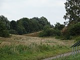
The Wisseler Dunes - "De Dunn"
The Rhine has repeatedly washed up sand that has been blown away by the wind. Inland dunes formed in Wissel . According to the Kleve Nature Conservation Center , they were created in the Middle Ages . The dunes have served the population as communal cattle pastures ( common land ) since the 14th century . Every year on May 2nd, the small farmers drove their cows into the dunes, what was called "in flocks". Even during the frequent floods of the Rhine, the animals found shelter and food here. The villagers who used the dunes were also responsible for their maintenance and care.
At the beginning of the 1930s - by order of the state - the Reich Labor Service leveled a large part of the dunes towards the village to create a glider airfield. However, the rest of the dune landscape has been under nature protection since 1935 . Today it is municipal property.
Picture gallery
Wisseler dunes

Wisseler dunes

Wisseler See
Wisseler mill


Attractions
Today's parish church of St. Clemens is a former collegiate church of the Counts and Dukes of Cleves . The 1150 built three-aisled Romanesque tuff - basilica is one of the most important Romanesque buildings of the 12th century in the Lower Rhine. In the 15th century the Romanesque apse was replaced by a Gothic choir, and around 1650 the roof ridge was raised. The Romanesque baptismal font has been preserved in the entrance area, and in the right aisle there is a late Gothic Pietà , which Heinrich Douvermann most likely created for the Altar of Seven Sorrows in the Sankt Nicolai Church in Kalkar.
With the secularization under Napoleon, the monastery was abolished in 1802. Some of the houses of the canons have survived. The “Stiftsmuseum Wissel” founded by Erich Hubbertz has been located in a listed canon house in the southeast corner of the church square since April 1997 . It offers exhibitions on art and history, especially local history.
House Kemnade, originally built as a moated castle at today's exit to Grieth, and still today surrounded by moats on three sides, dates mainly from the middle of the 16th century. Around 1850 it was rebuilt in the late classical style.
The “Wisseler See” leisure park with a campsite and natural open-air swimming pool is located south of the center of Wissel . The nature reserve "Wisseler Dünen", surrounded by gravel pits, spreads out to the east of the center of Wissel .
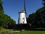
At the southern entrance to the village there is a windmill ("Huismanns Mölle") from 1873, which today serves as a meeting place for young people. The operator is Mühle Wissel eV. The mill was built by the married couple Johann and Johanna Paal from Bimmen-Keeken , who purchased land in the tobacco village of Wissel and built a house with agricultural stables and the mill. After the hoped-for economic success did not materialize, the family sold the property including the mill and emigrated to America with eight children, where they became rich. The Paals were succeeded by the married couple Johann Theodor Huismann and their children, who were already active as millers, bakers and farmers in the community. They had a motor built into the mill so that they could grind even when there was no wind. During the Second World War, the neighboring mill "Peerenboom" burned down, Huismann's mill had only minor damage and could be repaired. It remained in operation until the 1950s and was occasionally used for grinding. It was acquired by the Kleve district in 1963 and given to Mühle Wissel eV for use in 1973 . In the years 1976/77 there was an expansion by expanding the earth walls. The mill still contains the original grinder with large wooden gears. In addition, the visitor will find lounges, bedrooms and training rooms, kitchens and sanitary facilities and can be rented and used by groups of young people.
swell
- ↑ City portrait. City of Kalkar, accessed October 27, 2019 .
- ^ Frank Siegmund: Merovingian time on the Lower Rhine. Rhenish excavations 34th Rheinland-Verlag, Cologne 1998, p. 85 u. 439 with plate 219.
- ↑ D. von Detten: The gravel pit in the old Rhine bend from Kalkar-Wissel. Excavations in the Rhineland '83 / 84, Bonn 1985, pp. 183-187.
- ^ A b Inge Breidenbach: St. Clemens in Kalkar-Wissel ( Memento from March 11, 2007 in the Internet Archive ). Rheinische Kunststätten - issue 109, edition 1992.
- ↑ Helmut Rotthauwe: Kostbarkeit Kalkar; Kleve, 1980, p. 305.
- ↑ Dieter Kastner: The Counts of Kleve and the emergence of their territory from the 11th to the 14th century, in: Land in the center of the powers - The Duchies of Jülich, Kleve, Berg; Kleve, 1984, p. 53.
- ↑ Helmut Rotthauwe: Kostbarkeit Kalkar; Kleve, 1980, p. 306.
- ↑ Helmut Rotthauwe: Kostbarkeit Kalkar; Kleve, 1980, p. 253.
- ↑ Helmut Rotthauwe: Kostbarkeit Kalkar; Kleve, 1980, p. 254.
- ↑ Martin Bünermann: The communities of the first reorganization program in North Rhine-Westphalia . Deutscher Gemeindeverlag, Cologne 1970, p. 79 .
- ↑ Nature Conservation Center Kleve : Inland dunes in Wissel.
- ↑ Festival brochure for the 110th anniversary of the mill and the 10th anniversary of the association in 1983.
literature
- Inge Breidenbach: St. Clemens in Kalkar-Wissel . Rheinische Kunststätten - issue 109, edition 1992.
- Helmut Rotthauwe called Löns: Kostbarkeit Kalkar , City of Kalkar (Ed.), Rheinland-Verlag, Brauweiler Abbey, Pulheim 1980, ISBN 3-7927-0558-3 ; Chapter “News from Wissel”, pp. 304–307.
- Alois Puyn: Calcar, you small town on the Lower Rhine - pictures from the year 1868 - 1945 , Völkersche Buchdruckerei and Buchhandlung Goch, Kalkar 1980; Chapter “A village with many faces - Wissel”, pp. 152–164.
- Günther J. Bergmann: Kalkar - the city guide for the center and the districts. With photos by Bernd Mörsen and maps and drawings by Karl-Heinz Rottmann , Mercator Verlag, Duisburg 2002, ISBN 3-87463-337-3 .
- Robert Scholten : Contributions to the history of Wissel and Grieth and to the genealogy of the Lower Rhine families , Kleve 1889.
Web links
- Wissel - The dune village
- Photo report about Wissel ( Memento from October 13, 2008 in the Internet Archive )
Altkalkar | Appeldorn | Bylerward | Emmericher Eyland | Grieth | Hanselaer | Hönnepel | Kalkar | Turnaround | Neulouisendorf | Niedermörmter | Wissel | Wisselward