
Reeser Schanz
|
FFH area "NSG Reeser Schanz"
IUCN category none - not specified |
||
 Aerial view of the Rees flood basin |
||
| location | Xanten , Wesel District , North Rhine-Westphalia , Germany | |
| surface | 71.13 hectares | |
| Identifier | DE-4204-301 | |
| WDPA ID | 555519459 | |
| Natura 2000 ID | DE4204301 | |
| Geographical location | 51 ° 45 ' N , 6 ° 25' E | |
|
||
| Setup date | 2004 | |

The FFH area NSG Reeser Schanz (identification DE-4204-301) is around 71 hectares and is located in the urban area of Xanten on the Lower Rhine . It is located on the left bank of the Rhine north of the Xanten district of Obermörmter and east of the Kalkar district of Niedermörmter . As an FFH area, it forms part of the European Natura 2000 network of protected areas . The part of the name "NSG" refers to the previously independent nature reserve designation of this area. The former NSG Reeser Schanz was considerably expanded in 2004 and renamed Reeser Schanz, Rheinaue between Obermörmter and Vynen, at Gut Grindt and Haus Lüttingen ; the FFH area lies entirely in this nature reserve. In addition, the area is also in the much larger EU bird sanctuary DE-4203-401 Lower Lower Rhine .
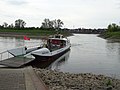
The Reeserschanz settlement area, which gives the FFH area its name - historically developed as a ski jump - is located in the urban area of Kalkar to the northwest outside the FFH area. There is a ferry connection to the town of Rees on the right bank of the Rhine .
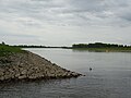
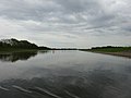
Rees flood basin
Between 2009 and 2015, the Duisburg-Rhein Waterways and Shipping Authority built the Rees flood basin, around three kilometers long, in the Rees Schanz area . This reduces the deep erosion of the Rhine and serves to protect against flooding , especially to relieve the Rees city wall. As a result of the construction work, the part of the protected area near the river was significantly redesigned; an ecologically beneficial stabilization of the wetland character in the floodplain area is expected.
Rees flood basin, NSG Reeser Schanz
Rees flood basin, NSG Reeser Schanz

Information board Rees flood basin
Rees passenger ferry


Flora and fauna
The Reeser Schanz mainly consists of couch grass and flood turf on a sandy-gravelly subsoil in the floodplain of the Rhine , which in particular serve as a habitat for numerous insect species . In parts of the area there are softwood alluvial forest bushes and alder and ash forests of different shapes . Reed grass reeds offer retreats for numerous water birds .
Species of common interest according to the fauna-flora-habitat and bird protection guidelines can be found in the Reeser Schanz in particular
- Combed Newts
- Forest and black sandpiper
- Common snipe , greenshank , redshank and godwit
- Meadow pipit
- Little ringed plover
- Common terns
- White-fronted geese and bean geese
- Teal , teal and shoveler
See also
- List of FFH areas in North Rhine-Westphalia
- List of nature reserves in the Wesel district (former NSG identification WES-011)
Web links
- Natura 2000 area DE-4204-301 in the specialist information system of the State Office for Nature, Environment and Consumer Protection in North Rhine-Westphalia
Individual evidence
- ↑ Nature reserve "WES-011 Reeser Schanz, Rheinaue between Obermörmter and Vynen, at Gut Grindt and Haus Lüttingen" in the specialist information system of the State Office for Nature, Environment and Consumer Protection in North Rhine-Westphalia
- ↑ Joachim Zeune : Monuments in Rees - Historical city walls. (PDF) City of Rees, Department 4 School, Culture and City Marketing, accessed on October 5, 2016 .
- ^ The Rhine fills the Rees flood basin for the first time. In: rp-online.de . January 16, 2015, accessed October 5, 2016 .
- ↑ The Rees flood basin. (PDF) Waterways and Shipping Office Duisburg-Rhein, November 2012, accessed on October 5, 2016 .
- ^ Stephan Gunkel, Nadja Fahlke (Erfurt river office): Flood basin near Rees. (PDF) (No longer available online.) In: Nature-compatible construction and maintenance concepts on federal waterways. BUND study. BUND , 2012, pp. 40-44 , archived from the original on May 13, 2016 ; Retrieved October 5, 2016 . Info: The archive link was inserted automatically and has not yet been checked. Please check the original and archive link according to the instructions and then remove this notice.

Old Rhine, Jenneckes Gatt, Niepgraben | Bachtal am Hasenkamp | Bachtal am Wefelnberg | Brook valleys southeast of Hünxe | Bagel forest in the Wackenbruch | Inland dunes on Lichterholzweg | Bislicher Island | Bislicher Meer and Wat Ley | Blink | Quarry and floodplain forest and adjacent oak forest on the eastern edge of the Leucht | Bruckhauser Mühlenbach | Gloamwood | Diersfordt Forest | Dingdener Heide | Drevenacker dunes | Droste Woy, Rheinaue between Wesel and Bislich | Erlenbruchwald and Landwehr in the Leucht | Wetland near Menzelen-Ost | Wet meadows on the Neuenroisfeld road | Wet meadows Bucholter Bruch and north slope Testerberge | Research area in the Orsoyer Rheinbogen | Fossa Eugeniana north of the Kamperbrucher field | Fürstenberg | Gartroper Mühlenbach | Grenzdyck | Sea of Hagen / Sea of Bellinghover / Lange Renne | Hasenfeld and Rhine foreland between Eversael and Ossenberg | Hemmings Schlinke | Hohe Ley, Wesendonker ditch, Urselmanns Ley, Tacke Ley | Hünxer Bachtal | In the fort west of the Vellenfurth | In the Fens | Island in the Haferbruchsee | Isselniederung | Issumer Fleuth | Rabbit Mountains | Kirchheller Heide, Schwarzbach | Little Dingdener Heide | Krummbeck | Luminous | Lichtenhagen | Lippeaue (WES-001) | Lippeaue (WES-092) | Lipperandsee | Loosen Mountains | Momm depression | Mumbeck Bach | Nieder Heide am Egelsberg | Niederkamp and Mönchschall | Nieper Altrheinrinne near Bloemersheim | Nieper Altrheinrinne | Northern Tüschenwald | Upper Hollebach | Plankenbach | Spring brook system Siegewinkelbach | Source stream system Osterbach / Langefortsbach | Rayener Mountain | Reeser Schanz, Rheinaue between Obermörmter and Vynen, near Gut Grindt and Haus Lüttingen | Renaturation site Büdericher Ziegelei | Rheinaue Bislich-Vahnum | Rheinaue Walsum / Dinslaken | Rheinaue between Büderich and Perrich | Rhine foreland north of the Ossenberger Schleuse | Rhine foreland east of Wallach | Rhine foreland between Mehrum and Emmelsum | Rigaud's bush | Risswald | Scholtenbusch | Schwafheimer Bruch | Stapelbach | Steinbach | Stollbach | Torfvenn / Rehrbach | Üfter, Rüster and Emmelkämper Mark | Weseler Aue and Leygraben near Flüren | Winkelscher Busch