
Bedburg-Hau
| coat of arms | Germany map | |
|---|---|---|

|
Coordinates: 51 ° 46 ′ N , 6 ° 11 ′ E |
|
| Basic data | ||
| State : | North Rhine-Westphalia | |
| Administrative region : | Dusseldorf | |
| Circle : | Kleve | |
| Height : | 20 m above sea level NHN | |
| Area : | 61.31 km 2 | |
| Residents: | 12,955 (Dec. 31, 2019) | |
| Population density : | 211 inhabitants per km 2 | |
| Postal code : | 47551 | |
| Area code : | 02821 | |
| License plate : | KLE, GEL | |
| Community key : | 05 1 54 004 | |
| LOCODE : | DE BDG | |
| Community structure: | 7 districts | |
| Address of the municipal administration: |
Rathausplatz 1 47551 Bedburg-Hau |
|
| Website : | ||
| Mayor : | Peter Driessen (independent) | |
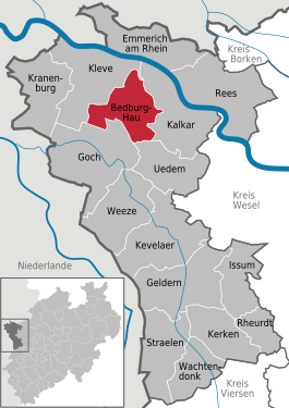
| Location of the community of Bedburg-Hau in the Kleve district | ||
  |
||

The municipality Hau is located on the lower Lower Rhine in the northwest of North Rhine-Westphalia and is a kreisangehorige community of Kleve in the administrative district of Dusseldorf . It is a member of the Euregio Rhine-Waal .
geography
Community structure
The community Bedburg-Hau is divided into the seven localities
- Hasselt
- Hasselt is famous for the large wall painting on the altar wall of the Catholic village church, which shows a very realistic picture of Jesus Christ crucified. The manor house Rosendal from the 15th century is also worth seeing. The house emerged from a stone keep built around 1433. The last renovation of the house took place in 1797
- With about 6000 inhabitants, Hau is the largest part of the municipality. The place name is derived from the term "Abhauen" or "Op den Hau", which refers to the establishment of the place after clearing.
Neighboring communities
The municipality of Bedburg-Hau borders the city of Kleve in the west and north , the city of Kalkar in the east and the city of Goch and the municipality of Uedem in the south .
history
The community owes its name to the establishment of the Rheinische Kliniken Bedburg-Hau in 1908. The station built for the clinics was also named Bedburg-Hau. Hau was the largest parish of the Till office at that time, Bedburg was the largest parish.
In February 1945, the so-called battle in the Reichswald took place in the nearby Klever Reichswald and in the area around today's Bedburg-Hau .
Territorial reform
Bedburg-Hau was created in its current form on July 1, 1969 during the first municipal reorganization program in North Rhine-Westphalia. The municipalities of Hau, Louisendorf, Schneppenbaum and Till-Moyland of the Till office and the Huisberden municipality of the Griethausen office were merged to form the new municipality of Bedburg-Hau.
On January 1, 1975, in the course of the second reorganization program in North Rhine-Westphalia, the old Kleve district was merged with the former Geldern district and sub-areas of the Moers and Rees districts to form the new Greater Kleve district on the Lower Rhine.
Population development
The following information relates to the current area of the municipality of Bedburg-Hau.
| year | 1973 | 1980 | 1985 | 1990 | 1995 | 2000 | 2005 | 2010 | 2015 | 2017 |
| Residents | 13,130 | 13,938 | 13,324 | 12,328 | 12,315 | 12,417 | 12,926 | 13,212 | 13,033 | 13,060 |
politics
Municipal council
Since the last local election on May 25, 2014, the CDU (45.3%, 12 seats), SPD (28.0%, 7 seats), Greens (14.9%, 4 seats) and FDP (11.7%) have been in the local council %, 3 seats). The turnout was 56.93%.
The next local election will take place in 2020.
mayor
Mayor of Bedburg-Hau has been Peter Driessen (independent) since 2004 . He was re-elected with 84.0% in the 2014 local elections . His opponent was Hans-Jürgen Wellmanns (CDU, 16.0%). The turnout was 56.95%.
Culture and sights

In 1997 the Museum Schloss Moyland opened . The world's largest collection of works and archive materials by and about Joseph Beuys is currently housed here. In addition, numerous art objects from the 19th and 20th centuries are made accessible to visitors. All works come from the collection of the brothers Hans and Franz Joseph van der Grinten .
In the mountain and valley in the district of Hau is the tomb of Moritz von Nassau , which he himself had erected next to his house in 1678. After his death in 1679 he was only temporarily buried there before his body was transferred to the family crypt in Siegen a year later . The tomb consists of the cast-iron , richly decorated tumba and quarter-circle walls, into which ancient Roman works of art were incorporated, which were brought to the newly founded antiquities museum in Bonn in 1820 and replaced with copies. The tomb was damaged several times and restored.
The parish church of St. Markus in Schneppenbaum is the former monastery church of the Bedbur (g) Premonstratensian monastery . The original tower and east aisle of the Romanesque cruciform church from the 12th century have been preserved with the younger Gothic choir. The remaining parts of the building were demolished at the end of the 18th century and were restored from 1900 to 1902 in a neo-Romanesque style.
Listed buildings are the Old Catholic Parish Church of St. Antonius Abbas and the Rosendal House . The Church of St. Antonius was consecrated in 1988.
economy
The LVR-Klinik Bedburg-Hau is one of the largest clinics in North Rhine-Westphalia and treats mental and neurological diseases.
traffic
The Hau station is located on the left Lower Rhine route . It is served every 30 minutes Monday to Friday and every hour on weekends and public holidays from the RE 10 Niers-Express Kleve– Düsseldorf via Krefeld . The local rail passenger transport is carried out by NordWestBahn (NWB), which uses LINT 41 diesel multiple units in single to triple traction.
In the municipal transport run a number of bus lines for the development of the region and the urban area. The regional tariff of the Verkehrsverbund Rhein-Ruhr (VRR) and the NRW tariff apply to all local public transport .
Bedburg-Hau is connected to the federal highway 57 ( E 31 ) via the federal highway 9 .
The closest airports are Niederrhein Airport in Weeze and Düsseldorf Airport .
education
- Community elementary school St. Markus Bedburg-Hau (locations in Schneppenbaum and Hasselt (former St. Stephanus elementary school Hasselt))
- Catholic denominational primary school St. Antonius Hau
- Joseph-Beuys Comprehensive School Kleve (partial location Bedburg-Hau)
- Dietrich Bonhoeffer School, Rhine. School for the handicapped
- LVR nursing school
- Technical school of the LVR for curative education care
Sons and daughters of the church
- Johannes Maria Verweyen (1883–1945), philosopher
- Jakob Imig (1905–1994), dialect poet and local researcher
- Josef van Eimern (1921–2008), forest and agricultural meteorologist
- Margot Potthoff (* 1934), writer
- Willi Lippens (* 1945), soccer player
- Werner Deutsch (1947–2010), professor of psychology, psychodramatist and trained tenor
- Ulrich Bister (1948–2008), theologian, church historian, educator
Individual evidence
- ↑ Population of the municipalities of North Rhine-Westphalia on December 31, 2019 - update of the population based on the census of May 9, 2011. State Office for Information and Technology North Rhine-Westphalia (IT.NRW), accessed on June 17, 2020 . ( Help on this )
- ↑ Martin Bünermann: The communities of the first reorganization program in North Rhine-Westphalia . Deutscher Gemeindeverlag, Cologne 1970, p. 79 .
- ↑ Population of all municipalities in North Rhine-Westphalia from December 31, 1962 at the end of each year according to the current territorial status
- ↑ a b c Election results for the 2014 municipal elections, the Niederrhein municipal computing center
Web links

Bedburg-Hau | Emmerich am Rhein | Geldern | Goch | Issum | Kalkar | Kerken | Kevelaer | Kleve | Kranenburg | Rees | Rheurdt | Straelen | Uedem | Wachtendonk | Weeze