Louisendorf
|
Louisendorf
Community Hau
Coordinates: 51 ° 43 ′ 40 ″ N , 6 ° 13 ′ 55 ″ E
|
|
|---|---|
| Height : | 41 m |
| Area : | 9.41 km² |
| Residents : | 525 (December 31, 2016) |
| Population density : | 56 inhabitants / km² |
| Incorporation : | 1st July 1969 |
| Postal code : | 47551 |
| Area code : | 02824 |
Louisendorf is part of the municipality of Bedburg-Hau in the Kleve district ( North Rhine-Westphalia ). It is part of the so-called Palatinate Language Island on the Lower Rhine .
geography
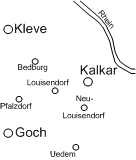
Like the other villages on the language island, Louisendorf is located on the Lower Rhine ridge , a glacial ridge on the left Lower Rhine in the city triangle of Goch , Kalkar and Kleve . The village forms the approximate center of the language island.
history
Louisendorf, named after Queen Louise (1776–1810), was built in 1820 on the orders of the Prussian King Friedrich Wilhelm III. as a branch settlement for emigrants from the Electoral Palatinate . Because of their Protestant faith, they had left their mostly Catholic homeland in 1741 and got stuck on the Dutch border on their way to Pennsylvania ( USA ) . The settlement areas between Goch , Kleve and Kalkar - first Pfalzdorf , then Louisendorf and finally Neulouisendorf - are still referred to as the "Palatinate language island". However, the dialect, the "Pälzersch", is less related to the Palatinate and more to the Hunsrück . The name “Palatinate” does not indicate a linguistic but rather a political origin, namely the Electoral Palatinate. In the 1810s, the Pfalzdorfer pastor Johann Friedrich Neuhaus was particularly strong in favor of the desire to expand the initial settlement area by founding the branch community.
The description of the coat of arms of Louisendorf reads: “In silver three blue cornflowers in a ratio of 2: 1 with golden clusters .” The cornflowers are reminiscent of Queen Louise's favorite flower.
In the vicinity of Louisendorf and the nearby Klever Reichswald , the so-called Battle of the Reichswald took place towards the end of the Second World War in February 1945 . Then the Allies were able to build a bridgehead over the Rhine near Wesel and subsequently take the Ruhr area.
On July 1, 1969, Louisendorf was incorporated into the newly formed community of Bedburg-Hau.
The Louisendorf association has been maintaining the Jakob Imig Archive , named after the dialect poet and local researcher Jakob Imig (1905–1994), a descendant of the settlers, since 2004 ; it was opened to the public in 2005.
Settlement
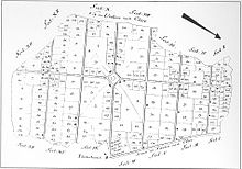
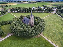
The original settlement structure with four streets that flowed into the corners of a diamond-shaped village square, Louisenplatz , is almost completely preserved. In the middle of 4 hectares and in the manner of a common land undeveloped square is in a space formed by trees roundabout , built 1860/61 Protestant Elizabeth Church, after the wife of the Prussian King Friedrich Wilhelm IV, Elisabeth Ludovika of Bavaria was named. Because of the peculiarities of its settlement layout, Louisendorf has been a listed area since 2002 :
“In the area of validity, the structure of the place and the appearance including the visual references to the Elisabeth Church, the village floor plan, the traditional historical buildings (individual monuments such as the building fabric that defines the area) and the open spaces are protected. The overall appearance is determined by
- the historical settlement plan in its division through the grid-shaped path system, partly laid out like an avenue, the central plaza formation and the traditional relationship between the built-up and agriculturally used undeveloped open spaces in the typical sequence: courtyard, vegetable garden, orchard, meadow, arable land
- the individual monuments or the external appearance of the area-defining building substance in their partially preserved groupings to neighborhoods along the streets. The characteristic house type for Louisendorf is the gable-free, single-storey brick residential / stable house with a long rectangular floor plan with a gently sloping hipped roof, with closed roof areas without roof structures and roof incisions. The buildings with secondary uses are subordinate to the building structure and are grouped around the courtyard.
- the characteristic planting of individual trees, groups of trees, rows of trees, orchards and cut hedges as the garden boundary. "
The 4 hectares large square and the square skirting Linden are also a conservation area designated ( "conservation area Louisenplatz" LSG-4203 to 0003).
Web links
- Website about Louisendorf
- Sound sample of the Louisendorfer island dialect on the website of the language department at the Institute for Regional Studies and Regional History of the Rhineland Regional Association
Individual evidence
- ↑ a b Louisendorf. From: www.bedburg-hau.de, accessed on February 9, 2017 .
- ↑ Martin Bünermann: The communities of the first reorganization program in North Rhine-Westphalia . Deutscher Gemeindeverlag, Cologne 1970, p. 79 .
- ↑ The Jakob Imig Archive. From: louisendorf.de, accessed on February 9, 2017 .
- ^ Bedburg-Hau municipal council: Statute for the Louisendorf monument area in the Bedburg-Hau municipality . September 25, 2002.
- ↑ Landscape plan district of Kleve, Gocher Heide, No. 7, textual representations and determinations. (PDF) Kleve district, December 24, 2010, p. 42 , accessed on April 29, 2017 .


