
Reesereyland
|
Reesereyland
City of Rees
Coordinates: 51 ° 45 ′ 30 ″ N , 6 ° 25 ′ 6 ″ E
|
||
|---|---|---|
| Area : | 4.1 km² | |
| Residents : | 0 | |
| Population density : | 0 inhabitants / km² | |
| Incorporation : | 1st July 1969 | |
| Postal code : | 46459 | |
| Area code : | 02851 | |
Location of Reesereyland in North Rhine-Westphalia |
||

Reesereyland , today often also called Reeser Eyland , is a nature reserve in the Reeser urban area and a now uninhabited district of the city of Rees in the Kleve district in North Rhine-Westphalia . Until 1969 Reesereyland was an independent municipality in what was then Rees County .
geography
Reesereyland is an old Rhine peninsula southeast of the Rees core city, in the east bounded by an arched arm of the old Rhine and in the west bounded by the current course of the Rhine . In the Middle Ages the area was still on the left bank of the Rhine. On Reesereyland was a small peasantry that existed in modern times only three yards, the van Willichshof , the Steppenhof and the United Sandenhof . Two arms of the river, created by gravel mining, lead from the Rhine to the peninsula, where there are landing stages for cargo ships and their loading. The area on both sides of the Old Rhine is part of the KLE-030 Old Rhine Reeser-Eyland nature reserve . The former municipality Reesereyland had an area of 4.1 km².
history
Since the 19th century Reesereyland formed a rural community in the mayorry Rees-Land (since 1928 Amt Rees Land ) in the Rees district in the Düsseldorf administrative district . During the Second World War , one of the Allied forces' Rhine crossings as part of Operation Plunder took place near Reesereyland in March 1945 . On July 1, 1969, Reesereyland was incorporated into the city of Rees by the Rees County Reorganization Act . In the period that followed, all of the existing buildings were removed so that the area is now uninhabited.
Picture gallery

Dike on the Old Rhine
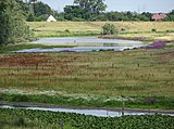
Reeser Old Rhine

Old Rhine and Reeser Eyland

Old Rhine and Reeser Eyland


Population development
| year | Residents | source |
|---|---|---|
| 1832 | 52 | |
| 1861 | 34 | |
| 1871 | 36 | |
| 1885 | 24 | |
| 1910 | 22nd | |
| 1925 | 25th | |
| 1939 | 23 |
See also
|
Old Rhine Reeser-Eyland
|
||
| location | North Rhine-Westphalia , Germany | |
| surface | 4.4 km² | |
| Identifier | KLE-030 | |
| WDPA ID | 162132 | |
| Geographical location | 51 ° 46 ' N , 6 ° 26' E | |
|
||

Web links
- "Altrhein Reeser-Eyland" nature reserve in the specialist information system of the State Office for Nature, Environment and Consumer Protection in North Rhine-Westphalia
- List of all NSG in the Kleve district
- Website of the nature conservation center in the Kleve district
- Landscape plan of the Kleve district for Rees, 2010
- 4203-401 Lower Lower Rhine. (EU bird sanctuary) Profiles of the Natura 2000 areas. Published by the Federal Agency for Nature Conservation . Retrieved July 22, 2019.
Individual evidence
- ↑ Measuring table sheet 4204 Rees from 1895
- ↑ a b Community dictionary of the Rhine Province 1930
- ^ A b Otto von Mülmann : Statistics of the government district of Düsseldorf. 1865, Retrieved May 5, 2019 .
- ↑ Operation Plunder and Varsity: The British and Canadian Rhine Crossing (Eng.)
- ^ Johann Georg von Viebahn: Statistics and topography of the government district of Düsseldorf. 1836, accessed on May 5, 2019 (digitized version).
- ↑ 1871 census
- ↑ Community encyclopedia for the Rhine Province 1885
- ↑ Uli Schubert: German municipality register 1910. Retrieved on February 2, 2017 .
- ^ Michael Rademacher: German administrative history from the unification of the empire in 1871 to the reunification in 1990. rees.html. (Online material for the dissertation, Osnabrück 2006).


Excavation lakes Lohrwardt and Reckerfeld | Old Rhine Reeser-Eyland | Aspeler-Narrow Sea | Bellinghover Sea | Bienener Altrhein, Millinger Meer and Hurler Meer | Empeler Meer | Grietherorter Altrhein | Dornick Harbor | Haffensche Landwehr – Sonsfeldsche Weiden | Hetter-Millinger break | Pretty Grändort | Long run | Sonsfeldsches Bruch, Hagener Meer and dune | Transitional moor in the Wittenhorster Heide