
Rhine
| Rhine | ||
 Sections of the course of the Rhine |
||
| Data | ||
| Water code | CH : 1, DE : 2, FR : A --- 0000 | |
| location | Europe | |
| River system | Rhine | |
| Drain over | Rhine → North Sea | |
| source |
Tavetsch Switzerland
(see source of the Rhine ) |
|
| Source height | 2345 m above sea level M. | |
| muzzle |
Rotterdam , Southern Bight , North Sea (see Rhine-Maas Delta ) Coordinates: 51 ° 58 ′ 52 " N , 4 ° 4 ′ 54" E 51 ° 58 ′ 52 " N , 4 ° 4 ′ 54" E |
|
| Mouth height | 0 m NAP | |
| Height difference | 2345 m | |
| Bottom slope | 1.9 ‰ | |
| length | 1,232.7 km | |
| Catchment area | 185,300 km² (with Maas 218,300 km²) | |
| Discharge at the Basel A Eo gauge: 35,897 km² Location: 865 km above the mouth |
NNQ (1958) MNQ 1808–2010 MQ 1808–2010 Mq 1808–2010 MHQ 1808–2010 HHQ (1876) |
201 m³ / s 425 m³ / s 1037 m³ / s 28.9 l / (s km²) 2657 m³ / s 5530 m³ / s |
| Discharge at the Rees gauge (MQ at the division: 2300 m³ / s) A Eo : 159,300 km² Location: 196 km above the mouth |
NNQ (1947) MNQ 1930–2010 MQ 1930–2010 Mq 1930–2010 MHQ 1930–2010 HHQ (1995) |
590 m³ / s 1070 m³ / s 2290 m³ / s 14.4 l / (s km²) 6670 m³ / s 11,300 m³ / s |
| Outflow (sum of the mouths) A Eo : 218,300 km² |
MQ Mq |
2900 m³ / s 13.3 l / (s km²) |
| Left tributaries | see chapter tributaries | |
| Right tributaries | see chapter tributaries | |
| Flowing lakes | Lake Constance , Tomasee , | |
| Big cities | see chapter settlements | |
| Residents in the catchment area | around 61 million | |
| Navigable | 883 km ( Large Rhine Ship ) | |
The Rhine ( Latin Rhenus ; French Rhin , Italian Reno , Rhaeto-Romanic , Dutch Rijn , Alemannic Ry ) is a 1,232.7 km long river in Western and Central Europe and one of the busiest waterways in the world.
The headwaters of the Rhine are mainly located in the Swiss canton of Graubünden , its mouth arms reach the North Sea in the Netherlands , the tributary of which it is the largest in water. From the confluence of the two main source branches, the Vorderrhein and Hinterrhein , the river is usually divided into the following main sections: Alpine Rhine , High Rhine , including the Seerhein through Lake Constance, Upper Rhine , Middle Rhine and Lower Rhine , including the estuary arms of the Delta Rhine .
The largest tributaries of the Rhine from the source to the mouth are, measured in length, catchment area and mean discharge (MQ), Aare , Neckar , Main , Mosel and Maas . With them, its catchment area has a share in nine states. The largest part of it in terms of area is in Germany , followed by Switzerland , France , Austria and the Netherlands. The Rhine is the tenth longest river in Europe and the seventh longest that flows directly into the sea. Among the rivers in the German-speaking area, it is the second longest after the Danube and before the Elbe .
Basic data


The Rhine has a total length of 1,232.7 km. Of these, 376 km are in Switzerland (including a large part of the 170 km long High Rhine including Untersee on the border with Germany ), 695.5 km in Germany (182 km of which are on the border with France ; one counts the Upper Rhine including Untersee in addition, you get 865.5 km for Germany and 161.2 km for the Netherlands. 883 km can be used for large shipping. The mean flow rate shortly before the branching of the estuary arms is around 2300 m³ / s. The highest flow rate ever measured there was 12,000 m³ / s (1926), the lowest 600 m³ / s (1947). The river system as a whole supplies the North Sea with an average of around 2900 m³ / s. The catchment area of the Rhine covers 218,300 km² (without the Meuse: 185,300 km²). † The administratively defined Rhine river basin district , which also includes adjacent parts of the coast and the coastal North Sea, is given as 198,735 km² (the Meuse basin is a separate river basin district). The river code of the Rhine in Germany is 2 . The Rhine is - with the Maas - the largest river northwest of the main European watershed .
etymology
The name “Rhine” possibly goes back to the Indo-European word root H 1 reiH- for “flow”. From this root arose u. a. also the German verb rinnen , the verb ancient Greek ῥέω rhéō , German 'flow' , the Latin rivus (river) - from it then Spanish rio and English river . The Celts called the river Rhenos , the Romans Rhenus . In ancient times, the river was also venerated as Rhenus Pater ("Father Rhine"). It is possible that the name was first used by the pre-Roman population in the headwaters of the Rhine and then adopted by the Celts and Romans. The name could also have been introduced by the Celts themselves.
The name of the Rhine in the Romansh and Germanic language forms of its catchment area is: Rhaeto-Romanic Rein , Italian Reno , Alemannic Rhy , French Rhin , Front Palatinate Rhoi , South Palatinate Rhei , Lëtzebuergesch (Luxemburgish) Rhäin , Ripuarian Rhing , Dutch Rijn , Frisian Ryn .
In the headwaters, numerous larger and smaller source rivers contain the name part Rhine or equivalents in various Romansh idioms such as Rein or Ragn . Examples:
- Vorderrhein area: Vorderrhein / Rein Anteriur , Rein da Medel ( Italian: Froda / Reno di Medel) , Rein da Tuma , Rein da Curnera , Rein da Maighels , Rein da Cristallina , Rein da Nalps , Rein da Plattas , Rein da Sumvitg , Rein da Vigliuts , Vals Rhine
- Hinterrhein area: Hinterrhein / Rein Posteriur , Reno di Lei ( Italian ), Madrischer Rhein , Averser Rhein , Jufer Rhein . In Dischma near Davos there are names such as Am Rin (place), Riner Tälli or Rinerhorn .
The Rhine itself is the namesake for the chemical element rhenium, which was discovered in 1925 .
geography
course
Sections

The course of the Rhine is subdivided into the area of the source rivers, the Alpine Rhine , Lake Constance consisting of Obersee , Seerhein and Untersee , the Upper Rhine , the Upper Rhine , the Middle Rhine , the Lower Rhine and the Rhine-Maas Delta .

Source rivers

The Rhine only bears its name without any distinctive additions from the confluence of the front and rear Rhine at Tamins - Reichenau . Above this point lies the widely ramified catchment area of the headwaters of the Rhine. It belongs almost exclusively to the Swiss canton of Graubünden and extends from the Gotthard massif in the west over a valley in Ticino and Italy in the south to the Flüela Pass in the east.
The sources of the Rhine
Traditionally, the Tomasee near the Oberalp Pass near Sedrun in the Gotthard region is the source of the Vorderrhein and the Rhine as a whole. The Hinterrhein rises in the high valley of the Rheinwald under the Rheinwaldhorn .
However, the source of the main flow path, which results from the larger amount of water at each confluence, lies somewhere else, namely in the east of the Hinterrhein area in the Dischma valley . The absolutely longest source branch, the Rein da Medel , rises south of the geomorphological main Alpine ridge in Val Cadlimo in Lago Scuro and Lago di Dentro in the Ticino canton.


Hinterrhein
The 64 km long Hinterrhein flows first east-northeast, then north. It flows through the three valley chambers Rheinwald , Val Schons and Domleschg - Heinzenberg . In between are the Roffla and Viamala canyons . Its source streams are in the Adula Alps ( Rheinwaldhorn , Rheinquellhorn, Güferhorn).
The Avers Rhine flows in from the south, the headwaters of which with the Reno di Lei (dammed in Lago di Lei ) are partly on Italian territory. At Sils , the Albula , which is at least equal to the Hinterrhein, flows from the region of the pass of the same name . The Albula draws its water primarily from the land water with the Dischmabach as the largest source stream, but also from the Julia (Gelgia) tributary, which is also important and descends from the Julier Pass .
Vorderrhein
The 75 km long Vorderrhein arises from numerous source streams in the uppermost Surselva and flows in an east-northeast direction. One source is the Lai da Tuma (Tomasee) (2345 m) with the Rein da Tuma flowing through it , which is usually given as the source of the Rhine.
In some cases longer, and in some cases equal tributaries such as the Reno di Medel , the Rein da Maighels and the Rein da Curnera flow to it from the south . The Ticino Val Cadlimo , drained by the Reno di Medel , crosses the geomorphological main Alpine ridge from the south . All tributaries in the source area are partially, sometimes completely, contained and fed to the local hydropower plants via reservoirs. In its lower reaches, the Vorderrhein flows through the Ruinaulta gorge through the Flims rockslide masses .
Alpine Rhine

At Tamins - Reichenau , the front and rear Rhine merge to form the Alpine Rhine. It falls from 599 to 396 meters over a length of barely 86 kilometers. The Rhine initially bends significantly to the north near Chur , the capital of Graubünden. The Rhine Valley is a glacial, broadly cleared, Alpine box valley . At Sargans , only a few meters high land step prevents the Rhine from flowing through the open Seeztal through Lake Walen and Lake Zurich towards the Aare . Below that, its west bank is Swiss, in the east it borders Liechtenstein and then Austria.

The Rhine, with its light water with a high suspended load content, has already largely filled Lake Constance, which initially reached far into the Alps, with sediments . The floods and heavy sedimentation in the western Rhine delta were countered by regulating the Rhine with punctures at Diepoldsau and Fußach . As a result, the Dornbirner Ach had to be routed parallel to the canal-like Rhine into Lake Constance. The cut-off Old Rhine initially ran in a swampy landscape , but was later canalised and made navigable below Rheineck .

The Rhine transports up to three million cubic meters of solids into Lake Constance every year. The Rhine delta ( inland delta ), which grows into Lake Constance, is largely a nature and bird sanctuary between the Old Rhine in the west and the lower Rhine gorge in the east and includes the Austrian villages of Gaißau , Höchst and Fußach . The natural Rhine once branched into at least two main branches. Many small islands (in Lake Constance dialect "Isel", cf. field name Esel ) were created as a result of sediment deposited . In the estuary area, permanent gravel mining with floating dredgers is necessary in order to control the sedimentation. The large sediment loads are also a consequence of the extensive amelioration upstream.
Lake Constance
Obersee
In Lake Constance, the milky, colder and therefore heavier Rhine water initially forms a compact flow at the surface of the gray-green sea water, but then falls abruptly at Rheinbrech from the seabed. The main current in the near-surface lake water runs from the island of Lindau , often clearly visible, along the northern German bank to around Hagnau on Lake Constance . A small part of the near-surface current branches off into the Überlinger See off the island of Mainau . The main flow is absorbed by the Rhine channel in the Konstanz funnel and directed to the drain.
The states bordering the Obersee are Switzerland in the south, Austria in the southeast and Germany with Bavaria in the northeast and Baden-Württemberg in the north and northwest.
Seerhein

The Seerhein river , which is only four kilometers long, connects the Obersee with the Untersee, which is about 30 cm lower . At the beginning of the Seerhein, in the middle of the old Konstanzer Rheinbrücke, the Rhine begins to be kilometered (see chapter Kilometrage ). The Seerhein was formed in the last millennia towards the end of an erosion-related lowering of the lake level by about ten meters, during which the island of Reichenau was also formed. Before that, Obersee and Untersee, as the overall name Bodensee only suggests today, were a contiguous lake.
Submarine
The Untersee also shows clear currents due to the thrust of the Rhine water. The southern part traversed by the Rhine current is occasionally also called the Rhine lake . Of the northern parts of the Untersee, only the Zeller See is somewhat affected by the currents; the Gnadensee remains almost untouched by the flow. An average of around 9 m³ / s of water from the Danube system flows into the Untersee via the Radolfzeller Aach .
Seerhein and Untersee form the border between Switzerland and Germany ; Exceptions are the city center of Konstanz, which is south of the Seerhein, and, near the outflow to the Upper Rhine, the city center of the Swiss city of Stein am Rhein on the north bank.
Upper Rhine

The Upper Rhine begins at Stein am Rhein at the western end of the Untersee. In contrast to the Alpine Rhine and Upper Rhine, it flows mainly to the west and falls from 395 m to 252 m.


The Upper Rhine now forms part of the border between Switzerland in the south and Germany in the north from Eglisau to the canton of Basel Stadt as far as Eglisau between the Swiss areas of Stein am Rhein, Schaffhausen and Zurich's Rafzerfeld .
Below Schaffhausen lies the Rhine Falls , with an average water flow of 370 m³ / s (average summer runoff approx. 700 m³ / s) behind the Dettifoss in Iceland it is the second largest waterfall in Europe according to the fall energy criterion . The image of the High Rhine is shaped by numerous barrages. On the few remaining natural sections, however, there are still several rapids, here called running . At Koblenz in Aargau , the Aare flows from the south , although it is shorter than the Rhine, but with an average discharge of 560 m³ / s, it is significantly richer in water than the Rhine with 440 m³ / s, and thus the main hydrological branch of the entire river system. At Rheinfelden the Rhine reaches a depth of 32 m in the St. Anna Hole .
Upper Rhine


In the center of Basel , the first major city on the course of the river, lies the “ Rhine knee ”; this is where the Upper Rhine ends. The Mittlere Brücke is officially considered the border between the Upper and Upper Rhine. The river now flows as the Upper Rhine to the north through the approximately 300 km long and up to 40 km wide Upper Rhine Plain , its height falling from 252 m to 76 m. The most important tributaries in this area are the Ill below Strasbourg from the left, the Neckar in Mannheim from the right and the Main opposite Mainz . The Rhine leaves the Upper Rhine Graben near Mainz and flows through the Mainz Basin . The section of the Upper Rhine from Mainz down through the Rheingau and Rheinhessen is also known as the Inselrhein . In this section of the river, which is up to 900 meters wide, there are large river islands called Rheinaue here .
The southern half of the Upper Rhine forms the state border between France ( Alsace , now part of the Grand Est region ) and Germany (Baden-Württemberg). The northern half forms the state border between Rhineland-Palatinate in the west on the one hand and Baden-Württemberg and Hesse on the other in the east and north. A curiosity of this borderline are the former districts of Mainz on the right bank of the Rhine , which have belonged to Hesse since 1945 .
The Upper Rhine Valley was already an important cultural landscape in Europe in antiquity and the Middle Ages . Today the Upper Rhine is the location of numerous important industrial and service companies with the centers of Basel, Strasbourg and Mannheim-Ludwigshafen. Strasbourg, the seat of the European Parliament , is one of the three European capitals on the Upper Rhine.
The Upper Rhine landscape has changed significantly as a result of the straightening of the Rhine in the 19th century. This increase in the flow rate and thus the deep erosion of the ground water level fell significantly, fell dry which side arms and floodplains - jungle fell sharply. In France, the Rhine side canal, which is important for navigation on the Rhine , through which the majority of the river water is channeled, was created. In some places there are larger compensation pools , such as the huge Bassin de Compensation de Plobsheim in Alsace.
Middle Rhine


In Bingen ending Mainz Basin , on Bingerloch the flow occurs at mean water at 77.4 meters above sea level as the Middle Rhine into the Rhenish Slate Mountains , and it is at 50 m leave. The Hunsrück and Eifel mountain ranges border on the left bank of the Rhine , the Taunus and Westerwald on the right bank . The characteristic, narrow shape of the valley originated through deep erosion of the river into a rising floe ( antecedent breakthrough valley ). The largest tributaries of the Middle Rhine are the Lahn and Moselle , which flow from the right and left near Koblenz. The river in the state of Rhineland-Palatinate runs almost the entire length of the Middle Rhine.
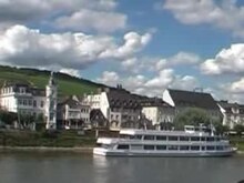
On the Middle Rhine, winegrowing and tourism dominate economically. The valley area between Rüdesheim and Koblenz is a UNESCO World Heritage Site Upper Middle Rhine Valley . At Sankt Goarshausen , the Rhine closes the famous Loreley rock with a sharp bend and there reaches a depth of 25 meters. With its high-ranking architectural monuments, the vine-covered slopes, its places huddled together on narrow bank ridges and the hilltop castles lined up on rocky outcrops, the Middle Rhine Valley is the epitome of Rhine romanticism .
Lower Rhine


Near Bonn , north of the Siebengebirge , the Rhine changes from the low mountain range to the North German lowlands and at the confluence becomes the Sieg to the Lower Rhine. It drops from 50 m in height to 12 m . The most important tributaries are the Ruhr and Lippe . Like the Upper Rhine, the meandering Lower Rhine also received a river bed that was fortified by hydraulic engineering. The dykes are further back here, so that the Lower Rhine has more flood space than the Upper Rhine.
The Lower Rhine lies entirely in North Rhine-Westphalia . Its banks are mostly heavily populated and industrialized, especially in the agglomerations of Cologne , Düsseldorf and the Ruhr area . Here the Lower Rhine flows through the largest conurbation in Germany, the Rhine-Ruhr metropolitan region . The most important port city is Duisburg with the largest inland port in Europe ( Duisburg-Ruhrorter Häfen ). Downstream from Duisburg, the region is more of an agricultural area. The second west-east shipping connection, the Wesel-Datteln Canal , which runs parallel to the Lippe, branches off 30 kilometers downstream at Wesel . The longest suspension bridge in Germany spans the 400-meter-wide river between Emmerich and Kleve . The Uerdinger line crosses the Rhine near Krefeld- Uerdingen , a language border that separates the Lower Franconian dialects from the Middle Franconian ones. The Rhine reaches the Netherlands to the northwest of Emmerich and Kleve.
Delta Rhine


With the division of the Rhine, the Rhine-Maas Delta, the most important natural spatial unit of the Netherlands , and thus the Delta Rhine begins at the Dutch-German state border . Because the Rhenish tributary predominates, the shorter term Rhine delta (Rijndelta) is also in use, which is then to be differentiated from the inland delta of the Rhine on Lake Constance , but also the longer Rhine-Maas-Scheldt Delta , because the Scheldt estuary is closely linked to the delta is.
The division of the Rhine at Millingen into Waal (two thirds of the mean discharge ) and Nederrijn are decisive for the shape of the Rhine delta , and the second and real bifurcation is the junction of the (Gelderschen) Issel (Dutch: IJssel ) from the Nederrijn near Arnheim . This creates three main stream courses, which, however, due to the many changes in course in historical times, do not have any consistent names:
.png)
- The largest and southern main arm is formed by the river Waal - Boven (Obere) Merwede - Nieuwe Merwede - Haringvliet . The water sequence Beneden (Lower) Merwede - Noord - Neue Maas - Neuer Wasserweg branches off from it as the most important shipping route . It is also followed by the river mileage. The Alte Maas branches off from the lower Merwede and meets the Neue Maas again in Rotterdam and forms the New Waterway.
- The middle arm is formed by Nederrijn and Lek . It then forms the New Meuse with the almost equally large Noord (see above)
- The northernmost arm is the (Geldersche) Issel, which reaches the IJsselmeer , which in turn flows into the North Sea via locks.

Until the Elisabethenflut in 1421 , the Meuse flowed a little south of the current line Merwede - Oude Maas towards the North Sea and formed a common, archipelago-like estuary with the Waal and Lek , whose condition at that time is difficult to grasp today because of numerous sea bays, estuary-like extended rivers, many islands and constant coastal changes . Until 1904 the Meuse flowed further upstream at Gorinchem into the Waal. For flood protection reasons the Meuse was then separated from the Rhine by a sluice ("Abgedämmte Maas") and a new drain was dug for it, consisting of Bergse Maas and Amer . Since the Haringvlietdamm was built in 1970, it has flowed again together with the Rhine into the sea, when the water levels in the Rhine are high, mainly through the locks of the Haringvlietdamm, and when the water is low, mainly via the Nieuwe Waterweg near Rotterdam.
The mouth area in the northwest, at the level of the dune chains interrupted here, has been known as the Maas mouth (Maasmond) since ancient times . This also explains the confusing use of the name Maas for today undoubtedly Rhenish lower reaches.

The hydrography of today's delta is characterized by the main delta arms, other stream arms ( Dutch Issel , Linge , Vecht, etc.) as well as smaller rivers and streams. Many rivers have been shut down ("dammed") and, like the numerous canals, are now used to drain polders . The construction of the Delta Works changed the Delta fundamentally in the second half of the 20th century. Rhine water is currently flowing into the sea at five points; the main water volumes on the Haringvliet dam and below Rotterdam ( Hoek van Holland ), the smaller IJssel and its tributaries through locks in Amsterdam and in the dike.
The Rhine-Maas delta is a tidal delta, because not only the sedimentation of the rivers, but also that of the tidal currents determine its shape. In the case of storm surges, this meant the greatest danger, because such floods could tear huge areas of land into the sea due to strong tidal currents. Before the construction of the Delta Works, the tidal influence was noticeable as far as Nijmegen , even today, after the regulatory measures of the Delta Works to protect against storm surges, the ebb and flow of the tides have an effect far inland.
During the Vistula glacial period , so much water was bound as ice in the polar caps that the sea level was about 100 m lower than today and the southern North Sea was dry. At that time, the mouth of the Rhine had shifted north to the Doggerbank , and the Thames was a tributary of the Rhine.
River system and catchment area
The Rhine is the main collecting vessel of a river system which, with an irregular course pattern full of abrupt changes of direction , reveals the history of its origins, which is still moving today and which is linked to the elevation of the Alps , and which branches off in a complicated way towards the mouth.
The Rhine flows in a generally north-north-westerly direction through very different natural areas such as the Alps, the northern Alpine foothills , the Upper Rhine Rift , the low mountain range and the Lower Rhine lowlands . Its course is divided into sections according to these landscapes, which are very different from each other. The headwaters of the Rhine are located in the transition area from the western to the eastern Alps . A little to the west of it, at the foot of the highest elevation in the catchment area, the Finsteraarhorn (4274 m), is the headwaters of the Aare . It is the larger river at the confluence with the Rhine and thus belongs to the main drainage line of the river system. The catchment area of the Rhine is constricted in the upper, southern third by the neighboring areas of the Rhone and Danube . The Rhine area has grown over the past three million years, particularly at the expense of these currents. To the south of this, the Rhine already reaches a third of its total water flow through the high runoff from the Alps. But also the Black Forest and Vosges later contribute large parts. A good 150 kilometers above the confluence with the North Sea, the river begins to branch out. The IJssel leaves the westward network of stream channels to the north. This water loss is more or less compensated for downstream by the Meuse flowing in from the south .
The catchment area of the Rhine borders (clockwise from the west) with those of the rivers Seine , Schelde , Ems , Weser and Elbe (all North Sea), Danube ( Black Sea ) and Po and Rhone (both Mediterranean ). The neighboring states of Switzerland (12.7%), Austria (1.1%), Germany (50.2%) and the Netherlands (13.4%) have shares in its area of 218,300 km² (100 %). In Liechtenstein (0.1%) it is the western border river and in France (14.3%) it is the eastern border river. Its catchment area includes parts of Belgium (6.7%) and Italy (<0.1%) as well as almost all of Luxembourg (1.2%). It drains around 70% of Switzerland and the Netherlands.
Tributaries

Water flow of the tributaries over 40 m³ / s:

The status of the Maas as an independent river or as a tributary of the Rhine has changed several times ( see also: Rhine-Maas-Delta ). With a discharge rate of 357 m³ / s and a length of around 874 km, it is one of the most important rivers of the Rhine-oriented water system. For flood protection reasons, it was directed directly to the North Sea in 1904 and then no longer flowed into the Waal , the main arm of the Rhine delta. Since the construction of the Haringvliet dam in 1970, it has again reached the North Sea together with the Rhine, depending on the control by the Delta Works, mainly via the sea-like waters of Hollands Diep and Haringvliet (former sea bays), or mainly via the Nieuwe Waterweg near Rotterdam .
The Aare is the largest and fourth longest tributary of the Rhine . This drains large areas of Switzerland and, with an average annual discharge of 560 m³ / s at the confluence, brings in significantly more water than the Rhine (470 m³ / s) itself, as the two large Alpine rivers Limmat and Reuss strengthen the Aare shortly before the confluence . In the series of the most water-rich Rhine tributaries, the Maas (357 m³ / s), the Moselle (320 m³ / s), the Main (211 m³ / s) and the Neckar (145 m³ / s) follow .
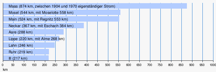
The longest Rhine tributaries after the Maas are the Moselle with 544 km (with Moselotte 558 km) and the Main with 524 km (with Regnitz 553 km). The Neckar, Aare, Lippe , Lahn , Ruhr and the Alsatian Ill also have a river length of over 200 kilometers .
Flow lengths of the tributaries over 200 km:
The table shows all tributaries with a total length of at least 60 kilometers or a water flow of at least 20 m³ / s. The 32 kilometer long Radolfzeller Aach , which flows into the Untersee , should also be mentioned, as it absorbs water from the Danube seepage.

| Rhine km | R / L | Tributary | Length in km | Catchment area in km² | mean discharge in m³ / s | River section |
|---|---|---|---|---|---|---|
| * | R. | Landquart | 51 | 616 | 25th | Alpine Rhine |
| * | R. | Ill (Vorarlberg) | 76 | 1281 | 66 | Alpine Rhine |
| * | R. | Bregenz Oh | 70 | 835 | 41 | Obersee |
| * | R. | Bad | 94 | 639 | 20th | Obersee |
| * | R. | Shot | 62 | 782 | 11 | Obersee |
| 65.0 | L. | Thur (Rhine) | 135 | 1696 | 47 | Upper Rhine |
| 100.17 | R. | Wutach | 90 | 1123 | 16 | Upper Rhine |
| 102.20 | L. | Aare | 288 | 17720 | 560 | Upper Rhine |
| 164.49 | L. | Birs | 73 | 922 | 15th | Upper Rhine |
| 169.30 | R. | Meadow (river) | 57.8 | 453 | 12 | Upper Rhine |
| 253.50 | R. | Elz | 90 | 1481 | 26th | Upper Rhine |
| 298.16 | R. | Tiny | 93 | 1406 | 28 | Upper Rhine |
| 311.19 | L. | Ill (Alsace) | 217 | 4761 | 54 | Upper Rhine |
| 334.50 | L. | Moder | 82 | 1720 | 17th | Upper Rhine |
| 343.95 | L. | Angry | 70 | 806 | 6th | Upper Rhine |
| 344.45 | R. | Murg | 79 | 617 | 18th | Upper Rhine |
| 355.50 | L. | volume up | 74 | 382 | 3 | Upper Rhine |
| 370 | R. | Pfinz | 60 | 240 | 2 | Upper Rhine |
| 400.2 | L. | Speyerbach | 60 | 596 | 3 | Upper Rhine |
| 428.2 | R. | Neckar | 384 | 13900 | 145 | Upper Rhine |
| 496.6 | R. | Main | 553 | 27292 | 211 | Upper Rhine |
| 518.7 | L. | Selz | 63 | 389 | 1 | Upper Rhine |
| 529.1 | L. | Near | 116 | 4067 | 30th | Upper Rhine |
| 585.7 | R. | Lahn | 250 | 5925 | 52 | Middle Rhine |
| 592.3 | L. | Moselle | 558 | 28286 | 320 | Middle Rhine |
| 610.2 | R. | Wied | 102 | 771 | 12 | Middle Rhine |
| 629.4 | L. | Ahr | 89 | 900 | 8th | Middle Rhine |
| 659.35 | R. | victory | 156 | 2857 | 53 | Lower Rhine |
| 703.3 | R. | Wupper | 117 | 827 | 17th | Lower Rhine |
| 735.5 | L. | Erft | 103 | 1838 | 16 | Lower Rhine |
| 780.1 | R. | Dysentery | 221 | 4485 | 81 | Lower Rhine |
| 797.7 | R. | Emscher | 84 | 775 | 16 | Lower Rhine |
| 814.45 | R. | lip | 268 | 4888 | 45 | Lower Rhine |
| 925.5 | L. | Maas (1904–1970 independent) | 874 | 34548 | 357 | Delta (Waal, Hollands Diep) |
| 1012.7 | L (abzw.) | Oude Maas | 30th | Delta (Nieuwe Maas) | ||
| (to Issel) | R. | Old Issel | 80 | 1208 | 9 | Delta (IJssel) |
| (to Issel) | R. | Berkel | 115 | 849 | 9 | Delta (IJssel) |
| (to Issel) | R. | Schipbeek | 86 | 352 | 4th | Delta (IJssel) |
| (to Issel) | R. | Vechte | 182 | 5741 | 50 | Delta (IJssel) |
* above Rhine kilometer 0 (Constance)
Islands
The Rhine islands are referred to as Wörth , Werth / Werd (cf. Insel Werd in Untersee ), Aue or simply as an island , depending on their geographical location or usage . Some islands are no longer islands in the literal sense due to electricity construction measures, but are still referred to as such. In most of the power arms that are no longer navigable by large shipping, marinas have emerged. In the Upper and Lower Rhine there are no more islands in the middle of the river due to the straightening of the Rhine , i. that is, they are on the right or left side near the bank.
Settlements
Metropolitan communities

There are 20 communities with 100,000 and more inhabitants on the banks of the Rhine . Quite a few emerged from Roman settlements, such as Basel , Strasbourg , Mainz , Koblenz , Bonn , Cologne , Neuss , Nijmegen , Utrecht and Leiden . These are among the most important cities on the Rhine and are all on the left bank of the Rhine, which is related to the role of the Rhine as the border of the Roman Empire. Among the major cities on the right bank of the Rhine there are a noticeably large number of younger residential cities with Karlsruhe , Mannheim , Wiesbaden and Düsseldorf .

The largest city on the Rhine with around one million inhabitants is Cologne, followed by Rotterdam and Düsseldorf with a good 600,000 inhabitants and Duisburg with just under 500,000. The cities of Utrecht, Bonn, Karlsruhe, Mannheim, Strasbourg and Wiesbaden have over 250,000 residents. Places with state capital functions are Chur , Vaduz , Bregenz , Schaffhausen , Basel, Wiesbaden, Mainz and Düsseldorf; Karlsruhe and Bonn used to be included in this list (both were compensated for this loss by important federal institutions). The government seats of three federal states in Germany are therefore on the Rhine. The large cities on the Rhine are mostly centers of much larger, directly contiguous settlement areas (agglomerations), which are dealt with in the next chapter.
The following figures, rounded to the nearest 1,000, refer to December 31, 2018:
| Rhine km | Urban parish | Ewz. | Section of the Rhine | Embankment of the city center |
|---|---|---|---|---|
| 167 | Basel | 172,000 | Upper Rhine | L ( Grossbasel ) |
| 294 | Strasbourg | 279,000 | Upper Rhine | L (city center on the Ill river , not directly on the Rhine) |
| 359 | Karlsruhe | 313,000 | Upper Rhine | R (city center not directly on the river) |
| 425 | Mannheim | 309,000 | Upper Rhine | R. |
| 425 | Ludwigshafen | 171,000 | Upper Rhine | L. |
| 499 | Mainz | 217,000 | Upper Rhine | L. |
| 503 | Wiesbaden | 278,000 | Upper Rhine | R (city center not directly on the river) |
| 591 | Koblenz | 114,000 | Middle Rhine | L. |
| 655 | Bonn | 327,000 | Middle Rhine | L. |
| 688 | Cologne | 1,086,000 | Lower Rhine | L. |
| 699 | Leverkusen | 164,000 | Lower Rhine | R. |
| 740 | Neuss | 154,000 | Lower Rhine | L. |
| 743 | Dusseldorf | 619,000 | Lower Rhine | R. |
| 762 | Krefeld | 227,000 | Lower Rhine | L. |
| 777 | Duisburg | 499,000 | Lower Rhine | R. |
| 884 | Nijmegen | 176,000 | delta | L ( Waal ) |
| 1000 | Rotterdam | 646,000 | delta | R ( Nieuwe Maas ) |
| (Nederrijn) | Arnhem | 159,000 | delta | R ( Nederrijn ) |
| (Oude Rijn) | Utrecht | 353,000 | delta | R ( Oude Rijn ) |
| (Oude Rijn) | Suffer | 125,000 | delta | R (Oude Rijn) |
Agglomerations

17 agglomerations with more than 100,000 inhabitants are located on the Rhine . (Agglomeration should be understood here as a contiguous settlement area that is intersected by state or municipal borders.) The three largest agglomerations and with more than one million inhabitants are the Ruhr area, Cologne and Mannheim. With Bonn, Düsseldorf, Rotterdam, Mainz-Wiesbaden, Basel and Karlsruhe, more than 500,000 residents have another six agglomerations. Strasbourg, Utrecht and Koblenz have over 200,000 inhabitants. Apart from the Ruhr area, these are monocentric agglomerations. The three agglomerations of Constance, Basel and Strasbourg cross national borders. The Rhine forms the main development axis of the blue banana , the central agglomeration of Europe.
| Rhine km | Agglomeration | Ewz. | Section of the Rhine | Largest municipalities in the agglomeration |
|---|---|---|---|---|
| 0 | Constancy | 111,000 | Seerhein | Constance, Kreuzlingen |
| 165 | Basel | 731,000 | Upper Rhine | Basel, Saint-Louis , Huningue , Weil am Rhein , Lörrach , Birsfelden , Allschwil , Binningen , Reinach , Münchenstein , Muttenz , Dornach |
| 287 | Strasbourg | 475,000 | Upper Rhine | Strasbourg, Kehl , Schiltigheim |
| 362 | Karlsruhe | 600.161 | Upper Rhine | Karlsruhe |
| 425 | Mannheim | 1,579,252 | Upper Rhine | Mannheim, Ludwigshafen |
| 500 | Mainz - Wiesbaden | 795.725 | Upper Rhine | Mainz, Wiesbaden, Ingelheim |
| 591 | Koblenz | 280,000 | Middle Rhine | Koblenz, Neuwied , Andernach |
| 655 | Bonn | 899.753 | Middle Rhine / Lower Rhine | Bonn, Siegburg , Troisdorf |
| 688 | Cologne | 1,846,241 | Lower Rhine | Cologne, Leverkusen , Hürth , Frechen , Brühl , Wesseling |
| 743 | Dusseldorf | 824,000 | Lower Rhine | Düsseldorf, Neuss , Dormagen , Ratingen |
| 775 | Ruhr area | 5,300,000 | Lower Rhine | Duisburg , Wesel , Mülheim an der Ruhr , Essen , Bochum , Dortmund (polycentric agglomeration) |
| 884 | Nijmegen | 161,000 | delta | Nijmegen |
| 975 | Dordrecht | 195,000 | delta | Dordrecht, Papendrecht , Zwijndrecht |
| 1000 | Rotterdam | 820,000 | delta | Rotterdam, Schiedam , Vlaardingen , Spijkenisse , Rozenburg |
| (Nederrijn) | Arnhem | 143,000 | delta | Arnhem |
| (Oude Rijn) | Utrecht | 365,000 | delta | Utrecht, De Bilt , Maarssen |
| (Oude Rijn) | Suffer | 189,000 | delta | Leiden, Leiderdorp , Voorschoten , Oegstgeest |
Medium-sized towns and municipalities
The most important medium- sized towns (20,000–100,000 inhabitants) above Basel include Chur , Bregenz , Konstanz and Schaffhausen , on the Upper Rhine Kehl , Speyer , Worms and Ingelheim , on the Middle Rhine Bingen , Andernach , Neuwied and Königswinter , on the Lower Rhine Wesseling , Dormagen , Meerbusch and Monheim , Wesel and Emmerich and in the Delta Dordrecht , Deventer and Zwolle .
The most important communities with less than 20,000 inhabitants include Vaduz , Kreuzlingen , Stein am Rhein , Breisach am Rhein , Rüdesheim and Remagen .
geology
The Rhine began with the collapse of the Middle Rhine Rift in the Rhenish Slate Mountains about 30 million years ago in the Tertiary (Oligocene). It began at Brohl and flowed into the sea at Bonn. The river systems that previously drained the Rhenish Slate Mountains, which rose out of the sea 300 million years ago (in the Upper Carboniferous), are largely unknown.
Over the next million years, the Rhine lengthened to the north as the sea slowly retreated. He used the Lower Rhine Rift Valley (part of the European rift system that stretches from Scotland to the Mediterranean. The Middle Rhine Rift was the part of the connection that had been missing until then.) And flowed into the North Sea in a delta between Roermond and Emden. During the Elster Ice Age (approx. 500,000 years ago) and then later from the Saale Ice Age (approx. 400,000 years ago) it was pushed westwards by the ice masses. It stayed that way to this day. The delta subsided about 1 million years ago. When the continental shelf and thus the English Channel lay dry during the Magpie Ice Age, it flowed through the English Channel and only flowed into the sea between Cornwall and Brittany. At that time it was twice as long as it is today.
The Urrhein partly had a different river bed than today. It flowed from about Worms over the area of Alzey through the middle of Rheinhessen and towards the Binger Pforte. He left the area around Oppenheim and Mainz on the right.
To the south, the Rhine lengthened over the next million years as the Alps and thus the entire southern area gradually rose from the late Middle Oligocene, around 28 million years ago. About 5 million years ago, at the beginning of the Pliocene (Tertiary), the beginning of the Rhine was still north of the Kaiserstuhl. About 1.9 million years ago (Pliocene / Pleistocene) the Upper Rhine in the Alpine foothills began to flow into the Rhine. Up until the Tertiary, the Upper Rhine did not flow north into the North Sea, but instead turned off at what is now Basel, crossed the Burgundian Gate and flowed into the Rhone and ultimately into the Mediterranean . During the Cromer-ice age about 730,000 years ago (Middle Pleistocene), the water of the Alpine Rhine that had previously flowed to the Danube were, by the ice masses of the Rhine glacier pushed towards the Upper Rhine / Lake Constance. As a result, the course of the Rhine was extended for the last time.
Geological and geomorphological processes have shaped the course and shape of the Rhine valley. In the early geological ages , the Rhine flowed in meanders on a wide and flat valley floor, which can still be seen today on the heights of the Rhine and can be demonstrated by Rhine gravel. Subsidence like the Cologne Bay caused the Rhine to deposit sand and gravel in the low mountain range and uplifts like in the Rhenish Slate Mountains , that it deepened in forced meanders. Since the landscape rose in spurts, when it came to a standstill it formed a wide valley floor, which it cut itself into the next time it rose. River terraces at the same height on both sides of the river today indicate these different phases of uplift. The youngest and lowest of the terraces is the island terrace in the course of the river itself. In the gravel fan of the Rhine from the Cologne Bay, a distinction is made between the low terrace, the middle terrace and the main Rhine terrace. In addition to the tectonics , the differences in water runoff between the cold and warm periods of the Ice Age also played a decisive role in their formation .
The Rhine was affected several times by inflow of lava from the Eifel. Even today, gas bubbles ( Mofetten ) emerge in the river bed of the Rhine in the Neuwied Basin area , similar to what can be observed in the Laacher See , which volcanologists attribute to volcanic activity below the Rhine.
Climate and hydrology
Flood


On the Upper Rhine, the states of Baden-Württemberg and Rhineland-Palatinate have set up some flood protection polders in order to be able to intercept flood peaks. The Ingelheim polder was flooded for the first time on January 16, 2011.
| date | Water levels | additional | |||
|---|---|---|---|---|---|
| Maxau | Mainz | Cologne | |||
| Mean water level (MW) |
516 cm | 301 cm | 321 cm | ||
| Rhine flood 2018 | January 2018 | 845 cm | 639 cm | 878 cm | in connection with storm Burglind |
| Rhine flood 2013 | June 2013 | 870 cm | 682 cm | 765 cm | |
| Rhine flood 2011 | January 2011 | 736 cm | 649 cm | 891 cm | |
| Rhine flood in 2007 | August 2007 | 858 cm | 533 cm | ||
| Rhine flood in 2002 | May 2002 | 750 cm | 632 cm | ||
| Rhine flood in 1999 | May 1999 | 884 cm | 672 cm | highest flood measured so far on the Upper Rhine |
|
| Rhine flood in 1995 | January 1995 | 845 cm | 703 cm | 1069 cm | |
| Rhine flood 1994 | May 1994 | 834 cm | 506 cm | ||
| Rhine flood in 1993 | December 1993 | 749 cm | 677 cm | 1063 cm | |
| Rhine flood in 1991 | December 1991 | 823 cm | 534 cm | ||
| Rhine flood in 1990 | February 1990 | 855 cm | 630 cm | 863 cm | |
| Rhine flood in 1988 | March 1988 | 845 cm | 770 cm | 995 cm | |
| Rhine flood in 1987 | June 1987 | 823 cm | 704 cm | ||
| Rhine flood in 1983 | May 1983 | 859 cm | 704 cm | 996 cm | |
| Rhine flood in 1983 | April 1983 | 847 cm | 706 cm | 984 cm | |
| Rhine flood in 1980 | February 1980 | 841 cm | 685 cm | 931 cm | |
| Rhine flood in 1978 | May 1978 | 847 cm | 764 cm | ||
| Rhine flood in 1970 | February 1970 | 737 cm | 987 cm | ||
| Rhine flood in 1955 | January 1955 | 694 cm | |||
| Rhine flood in 1926 | January 1926 | 1069 cm | |||
| Rhine flood in 1882 | December 1882 | 1052 cm | |||
| Rhine flood in 1882 | November 1882 | 795 cm | highest flood measured so far in Mainz |
||
| Rhine flood in 1833 | January 1833 | 793 cm | 994 cm | ||
| 1816 | Floods on the Lower Rhine, which led to a famine the following year |
||||
| Rhine flood in 1784 | February 27, 1784 | 1384 cm | with ice jam | ||
| Rhine flood 1374 | 1152 cm | ||||
| Magdalene flood 1342 | July 1342 | "The greatest flood in historical times in Central Europe". | |||
Low tide

- October 2018, lows: Koblenz gauge on October 22, 2018: 0.17 m; Cologne on October 23, 2018: 0.67 m
- November 2011, water level in Koblenz on November 28: 0.38 m, in Kaub on November 30: 0.47 m
- April / May 2011, 90-year low in May (Cologne): 1.25 m, historic low in Düsseldorf: 1.07 m
- Sept./Oct. 2009 (entire Rhine), water level in Koblenz: 0.93 m
- September 2003 (entire Rhine), historical low, water level in Kaub: 0.35 m; in Mainz 1.24 m; in Cologne 0.80 m
- November 1997 (total Rhine), water level in Koblenz: 0.87 m
- October 1985 (entire Rhine), water level in Koblenz: 0.72 m
- Summer of the century 1976: "Europe's great drought", extreme drought, parched land, withered fields, low water levels, cattle have to be slaughtered, up to 38 °
- December 1962 Upper Rhine, Mainz level: 1.17 m
- November 1947 Upper Rhine, water level in Mainz: 1.10 m.
- January 1947 (entire Rhine), water level in Koblenz: 0.43 m
The deep water in late autumn 2011 led to the largest evacuation in Koblenz since the Second World War on December 4 , because a British 1.8-tonne air mine was discovered and defused in the Rhine .
An annually recurring meteorological phenomenon, which causes more rainy weather in the second half of November, regularly changes the water level significantly. This phenomenon is also called Advent water .
Ice formation

In the past, the Rhine repeatedly froze completely or partially ( ice drift ). In the winter of 1783/84 with a subsequent drop in temperature, this led to enormous catastrophes (see above flood). In 1929 the river was frozen over almost its entire length. The Wiesbaden film pioneer Georg Dengel captured this natural spectacle with his documentary The Rhine in Ice Shackles . In 1947, drift ice destroyed the wooden makeshift bridge in Neuwied. In 1954 the ice from Oberwesel to Mainz built up. In February 1956 the ice from the Loreley built up over a distance of 40 km beyond Bingen. In the winter of 1962/63, parts of the Rhine were frozen over for the last time. At the Loreley the ice built up so much that no more icebreakers could get through, it was blown up. Several ships were stuck in the middle of the river on the Waal above Zaltbommel . Since the Dutch feared that if the ice jam broke out, the ships could bring down the Zaltbommel bridge, the ships were to be blown up. At the last moment, so to speak, icebreakers were able to free the ships. In the second half of the 20th century, these events became increasingly rare due to the increasing discharge of waste water and the waste heat in the cooling water of thermal power plants . In cold winters, ice sometimes still forms due to the lower current speed in the Dutch sailing area.
When there were still no refrigerators, the ice from the Rhine was packed in straw and stored in rock cellars and sold in summer. Funfairs also took place on the Rhine, and the ice cover was used to get to the other bank in carts.
Ice jams become dangerous when the areas above are endangered by floods or when the ice begins to move. Then bank areas can experience greater destruction.
environment


fauna
There is no complete overview of the fauna of the Rhine and their changes over time. Compared to today, one can for the time before the major straightening and bank reinforcements and before the strong inorganic and organic chemical pollution due to industry and increased population growth, i. H. Until about the middle of the 19th century, it was assumed that the indigenous fauna was significantly more abundant, with practically no human-made introductions ( neozoa ). These latter became particularly noticeable in the second half of the 20th century and especially from the beginning of the 1990s and have led to the fact that today the majority of the larger invertebrate species colonizing stones are introduced forms. These include, for example, the numerous representatives of the Asian cup mussel that can be observed at low tide .
Invertebrates
The species of larger invertebrates (animal macrobenthos ) have declined from around 160 species in the Lower Rhine around 1900 to around 25 species in 1971 and only recovered significantly from the 1980s onwards. Around 2000 they again reached around 130 species. In addition, more and more species were introduced during the 20th century, which by 1998 already represented around 20 additional species, some of them occurring in large numbers. In terms of biomass, they dominate the fauna of the animal macrobenthos in the Rhine today.
fishes
The Rhine is currently home to 63 species of fish again , only the sturgeon is missing. All fish that can be found are edible. Thanks to the construction of fish ladders at the weirs, migratory fish such as salmon and sea trout can now again ascend to the Upper Rhine and the tributaries and spawn there . The biodiversity of mussels , snails and insects has also increased, and there are also new immigrants .
The main share of the fish species are: roach , smelt , pike , catfish , lamprey , grayling , barbel , chub , eel , bleak , perch and bream . Newly immigrated species are: sunfish and pikeperch, as well as the marbled goby from the Danube and the white-fin goby . The tailor on the Upper Rhine and flounder and burbot on the Lower Rhine have increased their populations. The salmon has been reproducing increasingly naturally in some tributaries since 1994. The number of small animals in 2000 was almost as high as it was 100 years ago.
In the Lower Rhine region, around 33 to 39 native fish species have been found since around 1800, with the lowest number occurring in the period around 1910 to 1950. The proportion of introduced alien fish species increased from originally one or two species in the 19th century to around eleven species in the 1990s.
Waterfowl

From Lake Constance to its mouth, the Rhine is an important resting and wintering area. It also serves as a guideline for other bird species when migrating .
The winter population of water birds in 2000 was around two million specimens, divided into 42 species. The main types are:
- Herbivores: coot , white-fronted goose and mallard
- Mussel eaters: Tufted duck and pochard
- Fish-eaters: great crested grebes and cormorants , less than five percent of the total population
Biotope types

- Aquatic and amphibious area of rivers
- Natural floodplain waters
- Marshes , reeds and riparian perennials
- Grassland
- Arid habitats
- Riparian forests in current floodplains
pollution
Plastic cargo
In 2014, the Rhine was probably the first sea tributary in the world to be examined for contamination by plastic particles . Already in Tomasee 270 plastic particles in filtrate of 1,000 liters be found from the source of the Rhine. Ten types of plastic could be identified using infrared spectroscopy . Around 80 percent of the particles were polypropylene and 10 percent polyethylene . The remaining 10 percent were mostly polystyrene , PVC and ABS . The research team led by Andreas Fath ( Furtwangen University ) estimated that the Rhine carries at least eight tons into the North Sea each year.
In 2015, researchers from the University of Basel examined the Rhine water. With an average of 892,777 particles per square kilometer, the measured concentrations were among the highest in the world to date: At the knee of the Rhine near Basel still below that in Lake Geneva (220,000 particles / km², between Basel and Mainz 202,900 particles / km² ), but ten times higher in the Rhine-Ruhr area , at an average of 2.3 million particles / km². The peak was 3.9 million particles / km² 15 kilometers from the Dutch border near Rees . Extrapolated, the plastic load of the Rhine into the sea results in 191 million particles / km², about ten tons per year. It was noted that, in addition to fiber and fragment particles, mainly plastic beads were found, which indicates an industrial discharger of unknown origin.
The Rhine Cleanup Day was held for the first time on September 15, 2018 . Volunteers collected rubbish on the banks of the Rhine .
Pollution
| Pollutant | 1985 | 1992 | 2000 |
|---|---|---|---|
| Ammonium -N 2 | 37,000 | 16,800 | 6,800 |
| AOX | 4,675 | 890 | 1,100 |
| lead | 550 | 330 | 250 |
| cadmium | 9 | 5.9 | 5.1 |
| chrome | 500 | 220 | 150 |
| Phosphorus (total) | 32,000 | 13,000 | 13,000 |
| mercury | 6th | 3.2 | 1.6 |
| zinc | 3,600 | 1,900 | 1,400 |
The pollution of the Rhine has continuously decreased since 1960. This is due, on the one hand, to the systematic wastewater treatment through the construction of sewage treatment plants and, on the other hand, to the fact that the industry discharges less and less wastewater contaminated with chemicals and heavy metals into the Rhine. Despite the significant reduction in water pollution from household and industrial wastewater, the Rhine still transports heavy metals and chemicals such as pesticides towards the North Sea and thus pollutes the drinking water supply of the people living on the Rhine. The values given in the table refer to the Bimmen measuring point on the Lower Rhine. These data are published by the International Commission for the Protection of the Rhine (ICPR).
On November 1, 1986, the major fire in Schweizerhalle occurred . A fire broke out in a warehouse belonging to the Sandoz company in Schweizerhalle near Basel on the Rhine; With the extinguishing water , chemicals (in particular phosphoric acid esters and mercury compounds) got into the Rhine and destroyed a large part of animal and plant life there. Flora and fauna recovered in the months and years that followed; Floods made a particular contribution to this. The Rhine biocenosis has also recovered through the increased expansion and new construction of sewage treatment plants and other measures for water protection, but was then more populated by neozoa than before. The extinguishing water retention guideline was also issued as a result of this accident . Should a damage situation arise, a Rhine alarm is triggered.
Other toxins polluting the Rhine, for example micropollutants from pesticides and residues from medicines , cosmetics and cleaning agents , are not included in the table. For a whole year, the Rhine near Basel carries more than 42 tons of the sweetener acesulfame or around 13 tons of the antidiabetic metformin to the North Sea.
Economic use
Drinking water
Many cities take water from the Rhine for drinking water, these are mostly bank filtrate as in the Waterworks Koblenz-Oberwerth or the waterworks on the Petersaue which supplies the city of Mainz. The Netherlands are particularly dependent on this.
There are also processes with a system of absorption wells and delivery wells such as in the Schierstein waterworks , which makes a significant contribution to Wiesbaden's water supply .
In order to be able to react quickly in the event of accidents involving substances that are hazardous to water, seven international main warning centers between Basel and Arnhem were set up with the Rhine warning and alarm plan . The speed of propagation of a pollutant wave can be determined using a mathematical simulation (Rhine flow time model).
Viticulture and wine culture
The wine-growing shapes the natural and cultural area of the Rhine. Landscape names such as Rheingau , Rheinhessen or Kaiserstuhl (Baden) are also wine-growing areas . Wine growing is particularly difficult in the steep slopes of the Middle Rhine Valley . In many places, it was not possible to convert them to larger parcels that could be built on with machines. However, since the wine is particularly good on the steep slopes of the schisty slopes, some effort is worthwhile here. Wine is an economic factor for the region.
Power plants on the Rhine

Hydropower plants
At the source rivers of the Rhine, the Hinterrhein power plants and the Vorderrhein power plants with several reservoirs and power plant centers generate electricity. There are numerous run-of-river power plants from the Alpine Rhine to the central Upper Rhine .
- Alpine Rhine: Reichenau
- High Rhine: Schaffhausen - Neuhausen - Rheinau - Eglisau-Glattfelden - Reckingen - Albbruck-Dogern - Laufenburg - Säckingen - Ryburg-Schwörstadt - Rheinfelden ( old - new ) - Augst / Wyhlen - Birsfelden
- Upper Rhine with the Rhine canal: Kembs - Ottmarsheim - Fessenheim - Vogelgrun - Marckolsheim - Rhinau - Gerstheim - Strasbourg - Rheinau-Gambsheim - Iffezheim
Hard coal power plants


The large steam power plants on the Upper Rhine that run on hard coal and take cooling water from the river include the Rheinhafen steam power plant in Karlsruhe and the large power plant in Mannheim . On the Lower Rhine are the Walsum power plant , the power plant Voerde and the former power station Reisholz (1908-1966), which in 1918 was the largest coal-fired power plant in the world.
Nuclear power plants
On the Rhine there are five nuclear power plants with a total of eight reactor blocks, of which three nuclear power plants with four blocks are still in operation. In the following, the nuclear power plants are sorted in the direction of flow of the Rhine.
Leibstadt (CH)
The Swiss Leibstadt nuclear power plant (Rhine kilometer 107; near Waldshut-Tiengen ) has a boiling water reactor . This went into operation at the end of 1984; it has a net electrical output of 1220 MW.
Fessenheim (F)
The Fessenheim nuclear power plant is located at Rhine kilometer 210 in France on the west side of the Rhine canal (Grand Canal d'Alsace) . It has two identical pressurized water reactors with a net electrical output of 880 megawatts el each . With an efficiency of around 33%, the two reactors together feed around 3,600 MW of waste heat into the sewer; the NPP has no cooling towers. This corresponds to the calorific value of around 360,000 liters of oil per hour. According to the French permit dated May 26, 1972, the Rhine can be heated by 4 ° C in June, July and August and by 6.5 ° C in September, October, November, March, April and May by the two units of the NPP. In December, January and February the Rhine can even get 7 ° C warmer. The nuclear power plant is allowed to heat the Rhine up to 30 degrees.
In the hot summer of 2003 , the waste heat from Fessenheim led to a temperature increase of 1.7 ° C in the Rhine canal. At the beginning of August 2018, one of the two reactors had to be shut down due to the drought and heat in Europe .
The nuclear power plant is to be closed with the commissioning of a new European pressurized water reactor in the Flamanville nuclear power plant . Like the closure, this should take place by April 11, 2020 according to a decree by the French government.
Philippsburg (D)
The German nuclear power plant Philippsburg is located at the Rhine kilometer 389 and consists of two reactor blocks. Unit 1 went online in 1979 and was shut down in March 2011 ( nuclear moratorium after the Fukushima nuclear disaster ); Unit 2, a pressurized water reactor with a nominal net output of 1,402 MW el, went into operation in 1984/85. It is partially cooled with Rhine water. According to the nuclear phase-out in 2011, it will be switched off by the end of 2019 at the latest.
Biblis (D)
The former German nuclear power plant Biblis is located at Rhine kilometer 455. It has two reactor blocks of 1300 MW and partly used the Rhine for cooling. In order to be independent of the Rhine temperature and water flow, there are additional cooling towers. The power plant was shut down in 2011.
Mülheim-Kärlich (D)
The Mülheim-Kärlich nuclear power plant was designed for an output of 1,300 megawatts. The nuclear power plant has been controversial since its construction by the energy company RWE , not least because of its location in the earthquake-prone Neuwied basin. Because of this hazard, the reactor building was erected 70 meters from the originally planned location without a new building permit process .
As a result, the nuclear power plant had to be taken off the grid in 1988 - after almost two years in trial operation and exactly 100 days in regular operation - due to a court decision. The Rhineland-Palatinate state government issued a modified building permit in 1991, but this was revoked again by the Koblenz Higher Administrative Court in 1995. The Federal Administrative Court in Berlin confirmed this decision in 1998 in the last instance . In the opinion of the court, the knowledge about the earthquake hazard would have required a completely new approval procedure. In 2001 the power plant was finally shut down.
The Mülheim-Kärlich NPP is the largest of its kind in Germany to date and is being dismantled. After the uranium fuel rods were removed from the reactor block in 2002, the actual dismantling work began in 2004 and is expected to be completed by the mid-2020s. After extensive decontamination, most of the power plant site was sold to a recycling company that planned to demolish the 160 meter high cooling tower in 2015. The costs for the dismantling of the entire NPP were estimated at around 750 million euros. In 2016, however, the company withdrew from the purchase agreement, so that the dismantling was postponed.
Extraction of Rheingold
A special feature from the history of use was the extraction of gold from the sand of the Rhine to mint river gold ducats . They can be recognized by the legend EX AURO RHENI (= from the gold of the Rhine).
traffic

Long stretches of the Rhine are a shipping route and are accompanied on both sides by railway lines and motorways. Important business locations developed primarily at interfaces with other trade axes (such as Cologne, Koblenz, Mainz, Ludwigshafen, Mannheim, Karlsruhe, Strasbourg, Basel).
For the chemistry with coal / tar paints , the petrochemistry , the plastics industry and the oil refineries , coal and petroleum products are procured cheaply and processed; the chlorine chemistry ( polyvinyl chloride ) gets its salt from mass transport shipping. The transport volume in 2005 was 236.765 million tons. The most important economic factor after trade and industry is tourism .
Rhine shipping
The Rhine is navigable from its estuary in the Rhine-Maas Delta to Basel for larger ships and push convoys. From Breisach to shortly before Basel, shipping and most of the Rhine water is led through the Rhine side canal, which lies entirely on French territory , the rest of the Rhine forming the border is of no importance for shipping. Ships with flat superstructures that can pass the Mittlere Brücke in Basel can travel to the Rheinfelden port .
Because of the developed fairway and the seasonal, fairly regular rainfall in its catchment area, the Rhine is now largely navigable all year round from the mouth to the port of Rheinfelden . Before the expansion was completed, pilots were still common on the Middle Rhine until 1988 . On the Upper Rhine, between Mannheim and Iffezheim, pilots are still occasionally active. Above the Rhine Falls, the Rhine is closed to all shipping traffic up to the bridge at Neuhausen am Rheinfall . In the summer months there is a continuous ship connection from the Rhine bridge in Schaffhausen to Konstanz; the weir in Schaffhausen ensures a constant water level in this area up to Diessenhofen . Since the bridge there is very low, some ships lower their wheelhouse for the passage. The Rhine is not regulated upstream from Stein am Rhein , so it is navigable depending on the water level. The Alpine Rhine is completely closed to shipping, but the "Old Rhine" is navigable for two kilometers from the mouth to Rheineck SG .

Shipping on the Rhine and its tributaries has a long tradition, because important economic and industrial areas of Europe were connected by the river system or even lay on its banks before modern times. Today the Rhine is one of the busiest waterways in the world.
After the Congress of Vienna in 1816, a commission (later the Central Commission for Navigation on the Rhine) met in Mainz to work out a joint agreement between the states on the banks of the Rhine for navigation on the Rhine from Basel to the North Sea. The Rhine Shipping Act of March 31, 1831 (Mainz Act) guaranteed freedom of navigation to the open sea, abolished the stacking rights in Cologne and Mainz and obliged the riparian states to remove obstacles to shipping. Starting in 1817, the Upper Rhine was straightened so that it would become easily navigable in the first place. The Revised Rhine Shipping Act of October 17, 1868 ( Mannheim Act ) contains the principles of Rhine shipping that are still mainly valid today and exempted shipping from duties and customs duties. Rhine navigation courts were created . The Central Commission for Navigation on the Rhine , in which Switzerland, France, Germany, the Netherlands and Belgium are represented, has resided in the Palais du Rhin in Strasbourg since 1920 .
From Basel down the Rhine , the Rhine Navigation Police Ordinance passed by the Central Commission for Navigation on the Rhine applies as well as numerous other regulations regulating the safety of traffic and ships. The permissible sizes and formations of ships and push convoys are regulated from Basel to Bad Salzig (km 564.3) in waterway class VIb, then in class VIc.
The riparian states incorporate these regulations into their own national law. The enforcement duties of the shipping police on the Rhine are carried out by the neighboring states on their respective territories. The affected German federal states have deployed the water police for this purpose. In North Rhine-Westphalia it is subordinate to the Water Police Directorate at the Duisburg Police Headquarters. Mainz is the seat of the Rhineland-Palatinate Water Police Office and the water police department of the Hessian riot police is located in Mainz-Kastel. The regional council of Karlsruhe finally includes the water protection police for Baden-Württemberg as a department of the state police directorate.
In 2000, Germany and France agreed to cooperate in the performance of shipping police duties for the stretch on the Upper Rhine, on which the Rhine forms the border between the two countries. As a result, the Franco-German water police (Compagnie fluviale de gendarmerie du Rhin) was set up with its headquarters in Kehl and branches in Gambsheim and Vogelgrun , which provides its service with its own boats and mixed crews.
Federal waterway
The Rhine is a federal waterway on the entire stretch of German territory . However, this is of secondary importance on the rest of the Rhine stretch from Basel to Breisach.
The branch office of the General Directorate for Waterways and Shipping in Mainz (until April 30, 2013: Waterways and Shipping Directorate Southwest ) is the central federal authority responsible for the administration of the Upper Rhine and Middle Rhine from the Swiss border near Basel to the North Rhine-Westphalian border. The water and shipping authorities for the Rhine are subordinate to Freiburg (km 170.0 - 352.1), Mannheim (km 352.1 - 493.5) and Bingen (km 493.5 - 639.3 right / 642.2 left) ). In North Rhine-Westphalia, the water and shipping authorities in Cologne (km 639.3 right / 642.2 left - 759.7) and Duisburg-Rhine (km 759.7 - 857.7 right / 865.5 left) are responsible.
Channel connections

The Rhine has connections to other rivers via canals:
- The Mülhauser Canal (Canal de Mulhouse) branches off from the Rhine Side Canal below Basel at Kembs and meets the Rhine-Rhône Canal (Canal du Rhône au Rhin) in Mulhouse , but is only of interest for tourism.
- The Rhine-Marne Canal (Canal de la Marne au Rhin) connects with two canal tunnels over two watersheds Strasbourg over the Moselle and Marne with the Seine near Paris, suitable for pleasure craft and smaller ships. This canal is again connected to the Rhine via the Moselle, Saar and Saarkanal .
- The shortest navigable connection between the North Sea and the Black Sea runs over the Main and the Main-Danube Canal to the Danube .
- From Duisburg the Rhine-Herne Canal and from Wesel the Wesel-Datteln Canal connect the Rhine with the Dortmund-Ems Canal , which reaches the Ems . He branched-east connection as an important West through the North German Plain to Weser , Elbe and Oder of the Mittellandkanal from.
- The Meuse near Venlo was to be connected with the Fossa Eugeniana from Rheinberg in 1626 and, according to Napoleon's will, in 1809 by the northern canal from Neuss. Both projects were started but not completed.
- The Maas-Waal Canal branches off in Nijmegen (km 887.1) .
- From Tiel (km 913.5) the Amsterdam-Rhine Canal connects the Waal with Amsterdam.
- At km 926.1 there is a connection to the Maas via the Kanaal van St.Andries.
- At Woudrichem (km 952.5) is the access to the Afgedammte Maas.
- In Gorinchem (km 955.5) the Merwede Canal branches off to the Amsterdam-Rhine Canal.
There are also some unrealized canal projects in the Alps that would have connected the Rhine with the Rhone or Po .
Rhine level

The current water levels are displayed at water levels and electronically saved. The measured values are transmitted to the responsible waterways and shipping directorate and to the Federal Institute for Hydrology in Koblenz. Automatic answering machines (in Germany area code plus 19429) and official Internet offers of the neighboring countries keep the public informed of changes.
The most important shipping levels on the Rhine are: Konstanz , Rheinfelden , Basel -Rheinhalle, Iffezheim , Maxau , Speyer , Mannheim , Worms , Mainz , Oestrich , Bingen , Kaub , Koblenz , Andernach , Oberwinter , Bonn , Cologne , Düsseldorf , Duisburg-Ruhrort , Wesel , Rees , Emmerich am Rhein , Lobith , Pannerdense Kop , IJsselkop, Nijmegen Hafen, Tiel , Zaltbommel , Vuren , Krimpen , Dordrecht and Rotterdam .
Most important for shipping within the free flowing Rhine route are the Duisburg-Ruhrort, Kaub and Karlsruhe-Maxau gauges. Duisburg is crucial for the route to Koblenz, Kaub and Karlsruhe-Maxau for the southern sections of the Rhine. The water levels at the gauges (colloquially also for short: water levels) are important for the loading depth, which is determined from the possible diving depth at low water . For example, you load 80 to 120 cm onto the Kaub gauge, depending on your willingness to take risks. If necessary, a port or a roadstead must be called at low tide in order to lighten the ship . For uphill travel on the Middle Rhine, for example, this was possible up to the 1970s in Bad Salzig for tankers and in St. Goarshausen for other cargoes, today this practice has lost its importance. If the ships can no longer carry a full load, the freight becomes more expensive. That is why the cargo shipping companies levy a small water surcharge (Kwz) at low water levels at the Duisburg-Ruhrort, Cologne and Kaub gauges.
The high water marks I and II are set out in the Rhine Navigation Police Ordinance for all Rhine levels. From high water mark I, you should only drive in the middle third of the fairway, to the valley at a maximum of 20 km / h (exception: on a mountain stretch of 24 km / h). The water police monitor compliance. If the high water mark II is reached or exceeded, shipping in the area concerned is completely blocked. For more information, see “ Cologne Level ”.
River crossings
bridges

Bridges significantly shape the appearance of the Rhine. Julius Caesar had the first bridge over the Rhine built in 53 BC. At Urmitz ; The Romans used stone or wood as building materials , as did the bridge builders of the Middle Ages and early modern times . Bridges in Roman times were located at Bad Zurzach , Stein am Rhein , Kaiseraugst , Breisach am Rhein , Strasbourg , Mainz , Koblenz and Cologne .
In the middle of the 19th century, all bridges over the Rhine below Basel were ship bridges that could be opened to allow ships and the large Rhine rafts to pass. A change resulted from industrialization , which brought with it a greater volume of traffic as well as new building materials and techniques. In the second half of the 19th century and at the beginning of the 20th century it was mainly railway bridges that set a new accent due to their size and material ( steel ) (see Hohenzollern Bridge in Cologne ). Military aspects were also decisive for the bridge construction, for example in the case of the Ludendorff Bridge known as the Remagen Bridge .
In the heyday of modernism and the automobile traffic in the second half of the 20th century then took numerous new road bridges , including major highway bridges , the lead in the new buildings whose appearance in addition to steel and the material concrete co-determined new bridge construction techniques. Since the end of the 20th century, pedestrian and cyclist bridges (in Switzerland: “ bicycle bridges”) have set a relatively new accent (cf. Passerelle des deux Rives between Strasbourg and Kehl ).
Ferries


In addition to the bridges, ferries of various sizes play an important role. The yaw ferries , formerly known as flying bridges , made most of the Rhine crossings in the 19th century. Ferries driven by the current still exist in Basel and near Rastatt ; they are mainly used for tourism. This type of construction was replaced in the 19th century by steam ferries and later by motor ferries . In the Middle Rhine Valley there are no bridges between Wiesbaden and Koblenz on over 80 kilometers of river and between Neuwied and Bonn on over 40 kilometers, only ferry connections. There are two car ferries in the area of about 50 kilometers of the longest stretch of the river without a road bridge in the Upper Rhine between Worms and Mainz.
Cableways

Two cable cars cross the Rhine . The Cologne Rhine Cable Car was built for the Federal Garden Show in 1957 at the level of the Zoobrücke .
In Koblenz, the Rheinseilbahn was built as an attraction and an ecologically sensible transport connection to the 2011 Federal Garden Show . The 890 meter long tricable gondola connects the Rhine facilities with the plateau in front of the Ehrenbreitstein Fortress . It is the largest cable car of its kind north of the Alps in Germany. In order not to endanger the UNESCO World Heritage status of the Upper Middle Rhine Valley cultural landscape , operation was only planned until November 2013 with the subsequent dismantling of the facility. UNESCO decided on June 19, 2013 at the 37th session of the World Heritage Committee in Phnom Penh to allow the cable car to operate until 2026. The technically longest possible service life ends this year.

Ports
At the mouth of the Rhine, the port of Rotterdam is one of the world's largest seaports. It owed its upswing to industrialization in economic centers such as the Ruhr area that can be reached via the Rhine . Six Rhine ports are among the seven that handle goods to the largest German inland ports. The Duisburg-Ruhrorter ports are considered to be the largest inland port in Europe. Cologne owns the second largest inland port company in Germany . The next largest German Rhine ports are Ludwigshafen , Neuss , Mannheim and Karlsruhe . The Port Autonome de Strasbourg is the second largest inland port in France. The most important hubs for Switzerland's imports and exports are the Swiss Rhine ports in Basel.
Kilometrage
.JPG)
The existing mileage for Switzerland, Germany and the Netherlands has been valid since April 1, 1939, counts from Constance and replaces all previous classifications. Its zero point lies in the axis of the old Konstanzer Rheinbrücke and ends at kilometer 1036.20 west of Hoek van Holland (confluence with the North Sea at kilometer 1032.80). Shipping and all authorities are guided by it . This kilometering measures 167 km for the Seerhein, Untersee and Hochrhein (Constance to Basel, km 0–167), for the Upper Rhine 362 km (Basel to Bingen, km 167–529), for the Middle Rhine 159 km (Bingen to Cologne, km 529 –688) and for the German Lower Rhine 177.5 km (Cologne to the border, km 688–865.5). From a geological point of view, however, the Middle Rhine begins near Mainz, where the Rhine flows into the Mainz Basin , and ends above Bonn when it enters the Lower Rhine (Cologne) Bay .
From the Pannerdens Kop (km 867) below Millingen in the Netherlands, the kilometers in the three arms of the Rhine, Waal , Nederrijn and Issel, continue with the same name. In shipping it is therefore important to always include the respective fairway when specifying kilometers. On Dutch routes, the kilometer designation is indicated by boards with white numbers on a black background on only one of the banks. Only the full kilometers are displayed here.


The full kilometers of the Rhine river show large signs on both banks at right angles to the river axis . The 500 meter marks have a black cross on a white background. The remaining 100 meter marks ( hectometers ), about 100 cm × 50 cm rectangles and mostly made of concrete, are embedded directly in the bank. They are labeled with the numbers 1 to 4 and 6 to 9.
On the German-Swiss Rhine route between Stein am Rhein and Basel (Upper Rhine), the census measures the German bank of the Rhine. The same principle applies to the Franco-German Rhine route between Basel and Lauterbourg . On the rest of the route, count the length of the middle line of the river.
As early as 1806, Johann Gottfried Tulla , head of river engineering in Baden , began to create a coherent map of the Rhine. From 1826, under Tulla's direction, the straightening of the Rhine began, thereby shortening the Rhine between Basel and Bingen by 81 kilometers. A continuous length measurement was not finished until 1839 and published in the annual report of the Central Commission for Rhine Shipping from 1844. Some of the myriameter stones set as survey marks from 1863 still exist today. But that does not mean that a uniform division of kilometers has been introduced. From around 1883 to 1939, the banks of the Rhine, Baden , Bavaria , Hesse and Prussia, as well as Switzerland , Alsace and the Netherlands, each had their own kilometers for their sections of the Rhine. It began with zero at the national border and rose downstream; The exception was Hesse, which, like the Myriameter stones, continued to count the kilometers on the Mittlere Brücke in Basel. In contrast to this, the Upper Rhine was kilometers upstream from the Baden-Swiss border near Weil - the zero point of the Baden division. According to this system z. B. Königswinter at the Prussian kilometer 143 (today km 645).

The total leveling (height measurement) of the Rhine decided in 1863 also required a new length measurement, which was completed in 1890, but had to be repeated due to lack of accuracy. In 1904, Hessen notified the Central Commission of the successful completion and results of the length and height measurements on the Hessian river line. The other countries completed their measurements in the following years.
The individual countries had paid the greatest attention to the visual signs (kilometer tables and one hundred meter markers) and some of them, such as B. Hessen, provided with height bolts for their current leveling . In order not to have to move all these signs, the entire measurement from Constance was carried out at several previous system boundaries at the fixed kilometer point. By simply adding new numbers, all Swiss, Baden, Hessian and Prussian visual signs north of Bingen could continue to be used (and the Myriameter stones of the Hessian section at that time are still on whole kilometers). This resulted in three so-called short kilometers : The distance between km 22 and km 23 near Stein am Rhein (where the new kilometers running downriver from Constance coincide with the previous Swiss ones running upwards from Basel) was around 400 m shorter than a full one Kilometers between km 436 and km 437 near Roxheim - on the Baden-Hesse border - by around 365 m and those between km 529 and km 530 near Bingen - the last kilometer to begin in the former state of Hesse - by around 475 m. From Constance, the Rhine is around 1.2 kilometers shorter than the number of kilometers at the mouth.
rafting

Rafting with firewood and construction wood, especially from the Black Forest , was still carried out regularly on the Rhine until the middle of the 20th century. The rafts from Koblenz were up to 400 m long and 80 m wide and were operated by up to 500 rafters. Up to Koblenz the dimensions were smaller. With the construction of the railroad and the increase in shipping, rafting declined. After 1945 rafting was rare. It was finally discontinued in 1967.
Rafts also traveled from the canton of Graubünden to Lake Constance. From 1291 the Alpine Rhine was considered a Free Imperial Road . In Switzerland and other regions, rafts were loaded with merchandise, so-called oblast , mostly firewood or processed wood.
Culture

Parks
A series of park-like bank promenades along the Rhine are called Rhine facilities. From 1856 onwards , the future German Empress Augusta had the Rhine complex in Koblenz designed as a park. The park was later expanded to a length of 3.5 km. For the Federal Garden Show 2011 these were extensively restored. In Bingen , the Rhine facilities were rebuilt for the State Garden Show in 2008 and then marketed as a cultural bank. With the Rheinpark in Cologne , a sustainably used local recreation area was created for the 1957 Federal Horticultural Show . For the Federal Garden Show 1979 in Bonn, the Rhine meadows and agricultural areas south of the then government district were redesigned into a 160- hectare landscape park, the Rheinaue . Today it serves as a local recreation area and is used for major events such as open-air concerts, festivals and flea markets.
Rhine romance

Components of Rhine sagas are knights , dragons , lonely virgins on high cliffs ( Loreley ), careless boatmen in the crashing boat or hard-working dwarfs , the brownies . Apart from a few songs, the romanticism of the Rhine is also due to rebuilt castles such as Stolzenfels Castle near Koblenz or the Hohkönigsburg in Alsace. One of the most famous legends is the Nibelungenlied .
The numerous songs dedicated to the river are closely linked to the romanticism of the Rhine. The repertoire ranges from carnival hits like “Once on the Rhine” by Willi Ostermann to patriotic songs of the 19th century (such as “Between France and the Bohemian Forest” by August Heinrich Hoffmann von Fallersleben ) to the nationalist “ Watch on the Rhine ” by Max Schneckenburger . One of the most famous songs on the Rhine is " I don't know what it should mean " by Heinrich Heine .
Because of its importance in comparison to other German rivers, the Rhine is also enthusiastically and lovingly referred to as the Father Rhine . Personified by a powerful man, the symbolic river for Germany is also shown next to the main portal of the Berlin Reichstag building .
UNESCO world heritage
The Upper Middle Rhine Valley between Bingen / Rüdesheim and Koblenz was added to the UNESCO World Heritage List on June 27, 2002 . The World Heritage area extends over a length of 67 km along the breakthrough valley of the Rhine through the Rhenish Slate Mountains . The uniqueness of this cultural landscape is the extraordinary wealth of cultural evidence.
Others
- On the Namedyer Werth , a peninsula in the Rhine near Andernach , the Andernach geyser is the highest cold water geyser in the world.
- In 1966, a white whale caused a sensation, swimming up the Rhine to Bonn and back into the open sea for a month (see Moby Dick (Rhine) ) .
- The Rhine also drains a small part of Italy: The Reno di Lei carries water from the Lago di Lei in the Italian province of Sondrio into the Hinterrhein.
- The Rhine also discharges part of the water from the upper Danube ; The European watershed is bypassed underground in several places , see Danube infiltration .
- Actually, the Rhine below Koblenz (Canton Aargau) could also be called the Aare , because at the confluence with the Rhine , the Aare is the river with the greater amount of water (see above). The mostly very old naming of rivers does not only follow the apparently larger rivers, but occasionally also those whose valley maintains the direction or was better settled.
- About one percent of the Alpine Rhine water bypasses Basel or the Upper Rhine by taking it from the Bodensee water supply from Lake Constance near Sipplingen and feeding it as drinking water to many cities in Baden-Württemberg as far as Bad Mergentheim . The water flows back into the Rhine via the Neckar and Main.
- A presumed reversal of the number on the source sign on Lake Toma resulted in incorrect length information (1,320 km) in reference works , textbooks and official documents for decades .
- Until 2015, the official length of the Rhine was 1,238.8 km. It was only in January 2015 that the International Commission for the Hydrology of the Rhine announced the current value of 1,232.7 km.
- Due to the commuting routes from bank to bank, since at least 1939 the kilometers of shipping routes on the Rhine in the course books of the German railways have deviated from the kilometers of the Rhine.
- In 1969 Klaus Pechstein from Linz on the Rhine swam the Rhine from Switzerland to the North Sea in 260 hours (30 days). In 2012, the Swiss Ernst Bromeis failed in an attempt to break this record. In 2014, Furtwang's chemistry professor Andreas Fath swam from the source to the mouth; He wanted to sensitize the public to water protection and win sponsors for a water analyzer. In 2016 he published his impressions and initial test results of the water samples from the Rhine in Rheines Wasser - 1231 kilometers with the current .
- In July 2010, the Swiss Corrado Filipponi covered the 1161 km stretch from Chur to the mouth of the Rhine at Hoek van Holland in a kayak in a record time of 7 days, 10 hours and 16 minutes.
- In August 2017, the German Thorsten Bartzok covered the 1161 km long route from Chur to the mouth of the Rhine at Hoek van Holland in a kayak in the new record time of 6 days, 11 hours and 34 minutes.
Quotes
“The Rhine is the river that everyone is talking about and that nobody studies, that everyone visits and nobody knows. Nevertheless, its ruins occupy the intellectual highs, and this admirable river lets the eye of the poet and the eye of the publicist foreshadow the past and future of Europe under the transparency of its floods. "
Lists
- List of tributaries of the Rhine
- List of old Rhine waters
- List of Rhine bridges
- List of Rhine ferries
- List of landing stages on the Upper Rhine
- List of castles and palaces
- List of rivers in Germany
- List of rivers in Europe
- List of the longest rivers on earth
Television documentaries
- Monika Siegfried-Hagenow: How the salmon got back into the Rhine . WDR series documentary on Friday . First broadcast: September 17, 2010.
- Mathias Haentjes: How the steamers disappeared from the Rhine. WDR series Documentary on Friday ; First broadcast: July 9, 2010.
- The Rhine from above. WDR and Arte ; 5 × 52 min., First broadcast from March 11th to 15th, 2013 on Arte. (Source, course through Lake Constance, Rhine bridge from Konstanz with kilometer 0, Rhine side canal, castles, port of Duisburg, Rhine delta, Rotterdam).
- The Rhine - the river of history. Documentary, 87 minutes, first broadcast on Arte on June 11, 2016.
- Rheingold - faces of a river . SWR , 2014. (Overall representation exclusively from aerial photographs. Two source rivers, Rhine estuary in Lake Constance, Meersburg, Seerhein in Konstanz, Rhine Falls, Basel, Ludwigshafen, Mäuseturm near Bingen, Duisburg, two estuary arms, Utrecht, North Sea)
literature
- Laurenz Janscha : Collection de cinquante vues de rhin. Artaria & Comp. Vienna 1798. ( digitized edition from Dilibri accessed on July 9, 2017)
- Robert Batty : Scenery of the Rhine, Belgium and Holland. 4 volumes. Ed. R. Jennings, London 1824 ( digitized edition accessed July 8, 2017)
- Johann Georg Kohl: The Rhine. 2 volumes. Brockhaus, Leipzig 1851. ( (uni-koeln.de) )
- Elly Heuss-Knapp: The Rhine. (= The Blue Books ). Robert Langewiesche successor, Königsstein im Taunus 1963.
- Jörg Koch: Along the Rhine. A journey in historical pictures. Gudensberg-Gleichen 2018, ISBN 978-3-8313-3220-5 .
- Max Tauch : Rhenish landscapes. Paintings and watercolors from the 19th and 20th centuries. Rhenish Association for Monument Preservation and Landscape Protection e. V., yearbook 1972/73, Neuss 1973.
- Joseph Gregor Lang (ed.): Journey on the Rhine . Bachem Verlag, Cologne 1975, ISBN 3-7616-0271-5 .
- Wilhelm Ruland: The most beautiful legends of the Rhine . Stollfuß Verlag, Bonn 1985, ISBN 3-08-692101-3 .
- Wenceslaus Hollar : Travel Pictures from the Rhine. Catalog Landesmuseum Mainz, 1987.
- W. Gassen, Bernhard Holeczek (Ed.): Myth of the Rhine - A river - image and meaning . Wilhelm Hack Museum, Ludwigshafen am Rhein 1992.
- Klaus Honnef, Klaus Weschenfelder, Irene Haberland (eds.): Seized by the magic of the Rhine. To discover the Rhine landscape. Klinkhardt & Biermann, Munich 1992, ISBN 3-7814-0334-3 . (With numerous images of German castles and cities on the Rhine in works of art by English and Dutch artists from the past centuries)
- Horst Johannes Tümmers: The Rhine - A European river and its history . C. H. Beck, Munich 1994, ISBN 3-406-37972-9 .
- Gerhard Honekamp: The Rhine - A river becomes a myth. In: Learning History. No. 47, 1995, pp. 50-55.
- Bruno P. Kremer: The Rhine - From the Alps to the North Sea. Mercator-Verlag, Duisburg 2010, ISBN 978-3-87463-456-4 .
- M. Eckoldt (Hrsg.): Rivers and canals, The history of the German waterways. DSV-Verlag, 1998.
- Ingo Runde: On the importance and development of the Rhine trade in the early and high Middle Ages. In: Protection of the cultural heritage under water. Changes in European way of life through river and sea trade. Contributions to the International Congress for Underwater Archeology (IKUWA '99), 18. – 21. February 1999 in Sassnitz on Rügen. (= Contributions to the prehistory and early history of Mecklenburg-Western Pomerania. Volume 35). Lübstorf 2000, pp. 297-309, ISSN 0138-4279
- Gertrude Cepl-Kaufmann, Antje Johanning (ed.): Mythos Rhein. Cultural history of a stream . Scientific Book Society, Darmstadt 2003, ISBN 3-89678-465-X .
- Gertrude Cepl-Kaufmann, Hella-Sabrina Lange: The Rhine. A literary travel guide . Scientific Book Society, Darmstadt 2006, ISBN 3-534-18919-1 ( review ).
- Hans Joachim Bodenbach: VUES DU BORDS DU RHIN. A Rhine album from the early 19th century with aquatint engravings from the Koblenz publishers Fr. Röhling and K. Bädeker (Baedeker) in one volume. - The views published by Röhling. In: Bonner Geschichtsblätter. Volume 49/50, Bonn 1999/2000 (2001), pp. 285-304.
- State Office for Monument Preservation Rhineland-Palatinate: The Rhine Valley from Bingen and Rüdesheim to Koblenz. A European cultural landscape. 2 volumes. von Zabern, Mainz 2001, ISBN 3-8053-2753-6 .
- Hans Joachim Bodenbach: 200 years of romanticism on the Rhine - VUES DU BORDS DU RHIN - views of the Rhine from the publisher Karl Bädeker (Baedeker) in Koblenz. In: Contributions to the Rhine customer. (Rhein-Museum Koblenz), issue 54/2002, Koblenz 2002, pp. 26–55.
- Hans Chr. Hoffmann, Dietmar Keller, Karin Thomas (eds.): The Rhine - Our world cultural heritage. DuMont, Cologne 2003, ISBN 3-8321-7323-4 .
- Martin Stankowski: Left + Right, the other Rhine travel guide, from Cologne Cathedral to the Loreley. Kiepenheuer and Witsch, Cologne 2005, ISBN 3-462-03573-8 .
- Manfred Fenzl: The Rhine. Schaffhausen - North Sea and the IJsselmeer. Inland Water Guide. 4th edition. Delius Klasing, Bielefeld 2005, ISBN 3-89225-466-4 .
- Karsten Keune (Ed.): Longing for the Rhine. Rhineland regions in painting. With contributions by Irene Haberland and Elmar Scheuren. Bouvier, Bonn 2006, ISBN 3-416-03096-6 .
- Angela Photenhauer, Elmar Lixenfeld: Upper Middle Rhine Valley - World Heritage - From Bingen and Rüdesheim to Koblenz. German Foundation for Monument Protection, Bonn 2006.
- Wasser- und Schifffahrtsdirektion Südwest: Compendium of the Wasser- und Schifffahrtsdirektion Südwest. Organizational and technical data, inland navigation, tasks, waterways. Self-published, Mainz 2007.
- Clemens von Looz-Corswarem, Georg Mölich (ed.): The Rhine as a traffic route. Politics, law and economics since the 18th century. (= Series of publications by the Niederrhein Academy. Volume 7). Verlag Peter Pomp, Bottrop 2007. (Review in: Contributions to Rheinkunde. Issue 59/60, 2007/08, Koblenz 2008, p. 104)
- M: AI - Museum for Architecture and Engineering NRW e. V .: Dynamics and Change - The Development of the Cities on the Rhine 1910–2010 +. JOVIS, Berlin 2010, ISBN 978-3-86859-096-8 .
- Michael Prince of Prussia (ed.): The Prussians on the Rhine - castles, palaces, Rhine romanticism. Cologne 2011.
- Jochen Rahe, Martin Stieghorst, Urs Weber (eds.): Handbook Rhine. Primus Verlag, Darmstadt 2011, ISBN 978-3-89678-772-9 .
- Werner Böcking: Lively Lower Rhine. On the way between Duisburg and Emmerich. Sutton Verlag, Erfurt 2013, ISBN 978-3-95400-312-9 .
- Ingo Runde: The Rhine as an economic and transport axis. In: Jörg Peltzer, Bernd Schneidmüller, Stefan Weinfurter (eds.): The Wittelsbachers and the Electoral Palatinate in the Middle Ages. A success-story? Schnell & Steiner, Regensburg 2013, ISBN 978-3-7954-2645-3 , pp. 51-66.
- Klaus Göhring: The Rhine Valley from the air . A spectacular journey from Koblenz to Cologne . Rheinbach 2015, ISBN 978-3-95540-146-7 .
- Andreas Fath: Rhine water - 1231 kilometers with the current . Carl Hanser Verlag, Munich 2016, ISBN 978-3-446-44871-1 .
- Marie-Louise von Plessen (Ed.): The Rhine. A European River Biography , Prestel, Munich 2016, ISBN 978-3-7913-8308-8 .
- Björn Kuhligk and Tom Schulz: Rhine trip. Influence. His people. His stories. Zurich 2017. ISBN 978-3-280-05630-1
- Willi Jung (Ed.): The Rhine in the Franco-German Change of Perspectives , V & R unipress, Göttingen 2019 (Germany and France in Scientific Dialog, Volume 8), ISBN 978-3-89971-745-7 .
Web links
- International Commission for the Protection of the Rhine (ICPR) - website with an extensive archive on all aspects of the Rhine
- International Commission for the Hydrology of the Rhine Basin (KHR)
- Jens Stenglein: entertainment concept for the free flowing Rhine . (PDF; 4.3 MB) From the bulletin of the Federal Institute for Hydraulic Engineering No. 84 (2002) - Text about hydraulic engineering measures with a focus on bed load management (German and Russian)
- Pure Rhine and the struggle for an improved water quality BUND Südlicher Oberrhein, July 3, 2003
- Markus Kaiser, Max Baumann, Bernard Degen : Rhine. In: Historical Lexicon of Switzerland .
- Interregio Alpenrhein-Bodensee-Hochrhein (information on economic cooperation in large aglomeration)
Individual evidence
- ↑ a b c d Length of the Rhine (Update 2015) , International Commission for the Hydrology of the Rhine Area (KHR) , January 9, 2015, accessed on August 4, 2020.
- ↑ a b Federal Ministry for the Environment, Nature Conservation and Nuclear Safety: Hydrological Atlas of Germany, excerpt from chap. 3.2 (PDF; 3.4 MB), accessed on October 14, 2012.
- ↑ Federal Institute for Hydrology : Basel level data from UNDINE ( Memento from December 28, 2012 in the Internet Archive ) (data bases for the classification and evaluation of hydrological extremes), accessed on November 17, 2012.
- ↑ Federal Institute for Hydrology : Rees water level data at UNDINE ( Memento from August 11, 2014 in the Internet Archive ) (data bases for the classification and evaluation of hydrological extremes), accessed on November 17, 2012. Note: the data from the Emmerich water level downstream was not used, since the discharge data determined there according to various sources are a bit too high.
- ↑ Note: see also : river system of the Rhine
- ↑ Three tributaries of the Volga are longer: Kama , Oka and Belaja (across the Kama).
- ↑ The Elbe, with its main hydrological upper course, the Vltava, is even slightly longer than the Rhine
- ↑ Note: s. Installation under the river system of the Rhine
- ↑ Interactive Atlas of Switzerland ( Memento from May 4, 2011 in the Internet Archive ) - Landestopografie
- ^ Hydrological Atlas of Switzerland of the Federal Office for the Environment FOEN, Table_54
- ^ National map of Switzerland, sheet 1232 Oberalppass, 1:25 000, Federal Office of Topography, 2005 edition.
- ↑ Note: the geomorphological ridge line does not necessarily coincide with the watershed , since it refers to heights averaged in circles.
- ↑ bed load management
- ↑ Roland Schröder: Flow conditions in the Lower Lake Constance and the exchange of water between the individual lake basins . Report No. 15 of the International Commission on Water Protection for Lake Constance, accessed on August 6, 2015 (pdf, German, 2.10 MB)
- ↑ Neuhausen measuring station 1959–2016 (PDF) Federal Office for the Environment FOEN
- ↑ Untersiggenthal measuring station 1935–2016 (PDF) Federal Office for the Environment FOEN
- ↑ Rekingen measuring station 1904–2016 (PDF) Federal Office for the Environment FOEN
- ↑ NL / NRW / NDS: International Deltarhein management plan, 2009–2015
- ↑ B. P. C. Steenkamp, D. Ludikhuize: Relationship between Pollution Transport Rates at Lobith and Maassluis ( Memento of December 3, 2013 in the Internet Archive ) , Dordrecht, 1995, pp. 20 ff.
- ^ Martin Stock, Hans-Heiner Bergmann, Herbert Zucchi: Watt. Habitat between land and sea. Heide 2007, p. 20 f.
- ↑ Wolfgang Schirmer: The Middle Rhine in the focus of the Rhine history. In: Wighart von Königswald, Wilhelm Meyer: Erdgeschicht im Rheinland. Foslilies and rocks from 400 million years ago. Munich 1994, pp. 179-188.
- ^ Roland Walter: Geology of Central Europe. Stuttgart 1995.
- ↑ BAfG: The flood of the Rhine in January / February 1995 ( Memento from July 5, 2013 in the Internet Archive )
- ↑ BAfG: The Christmas flood of the Rhine 1993 ( Memento from November 14, 2016 in the Internet Archive )
- ↑ BAfG: The flood of the Rhine in February 1970 ( Memento from June 19, 2013 in the Internet Archive )
- ↑ Flood of the Rhine in December 1925 / January 1926 ( Memento of the original from September 12, 2014 in the Internet Archive ) Info: The archive link was inserted automatically and has not yet been checked. Please check the original and archive link according to the instructions and then remove this notice.
- ↑ BAfG: The flood of the Rhine in November, December 1882 and January 1883 ( Memento from August 1, 2015 in the Internet Archive )
- ^ Hans-Heinrich Bass: Hunger crises in Prussia during the first half of the 19th century. Scripta Mercaturae Verlag, St. Katharinen 1991, p. 161 ff.
- ↑ BAfG: The ice flood in 1784 in the Rhine area ( Memento from December 26, 2012 in the Internet Archive )
- ↑ BAfG: The Magdalenen floods in the summer of 1342 in the Rhine area ( Memento from May 15, 2013 in the Internet Archive )
- ↑ G. Tetzlaff, M. Börngen, M. Mudelsee, A. Raabe: The millennium flood of 1342 on the Main from a meteorological-hydrological point of view. In: Water & Soil. 54 (10), 2002, pp. 41–49, Berlin (online)
- ↑ a b bafg.de
- ↑ a b dapd-nrw, May 10, 2011: Rhine level reaches record low. In: koeln.de (November 3, 2011)
- ↑ Water: Rhine level in April never so low. In: Focus Online. April 29, 2011, accessed December 11, 2014 .
- ↑ Rhine shipping lacks water. on: verkehrsrundschau.de , October 1, 2009.
- ↑ steb-koeln.de, Stadtentwässerungsbetriebe Cologne (November 3, 2011)
- ↑ Climate history in July. Retrieved October 6, 2014 .
- ↑ The dry and low water period 1976. (2nd edition 1985) , chr-khr.org (83 pages) (PDF; 32 MB)
- ↑ donnerwetter.de
- ↑ epd: bomb Advent in Koblenz. In: badische-zeitung.de, Panorama, December 2, 2011 (December 4, 2011)
- ↑ The Rhine in Eisfesseln at the KULTURTAGE district festival . ( Memento from July 19, 2011 in the Internet Archive ) In: Wiesbadener Tagblatt . July 20, 2009.
- ↑ Rhineland-Palatinate: Topic of the week: ice cream. In: zeit.de. February 23, 1956, accessed December 11, 2014 .
- ↑ Bruno Streit : On the ecology of the animal world in the Rhine. (= Negotiations of the Natural Research Society Basel. Volume 102). 1992, pp. 323-342.
- ↑ Stefan Nehring: Alien species in German waters - a risk for biodiversity. In: Applied Science. Issue 498 (series of publications by the Federal Ministry for Consumer Protection, Food and Agriculture). 2003, pp. 40-52.
- ↑ Furtwangen University in cooperation with the Biological Institute Helgoland . Andreas Fath: Rhine water - 1231 kilometers with the current. Carl Hanser Verlag, Munich 2016, ISBN 978-3-446-44871-1 , p. 133.
- ^ Andreas Fath: Rhine water - 1231 kilometers with the current. Carl Hanser Verlag, Munich 2016, ISBN 978-3-446-44871-1 , p. 166.
- ↑ Thomas Mani, Armin Hauk, Ulrich Walter, Patricia Burkhardt-Holm: Microplastics profile along the Rhine River. In: Scientific Reports . 5, 2015, p. 17988, doi: 10.1038 / srep17988 .
- ↑ rhinecleanup.org
- ^ German press agency : "Rhine Cleanup Day": Thousands of helpers collect garbage on the Rhine In: aachener-nachrichten.de , September 16, 2018, accessed on September 16, 2018.
- ↑ swr.de: "Rhine CleanUp" - Sacrifice leisure time for a clean Rhine
- ↑ See also current and future development of chloride pollution in the Rhine catchment area. ( Memento of May 10, 2013 in the Internet Archive ) (PDF; 2.5 MB) Study on behalf of RIWA, 2008.
- ↑ Andri Bryner: Keeping rivers clean is provision for drinking water. In: eawag.ch , September 9, 2014, accessed on March 15, 2020.
- ↑ Water, groundwater, drinking water, water pollution and the Rhine . BUND , Regional Association of the Southern Upper Rhine, leading article
- ↑ Fessenheim nuclear power plant switches off the reactor due to heat In: saarbruecker-zeitung.de, August 5, 2018, accessed on August 6, 2018.
- ^ Badische Zeitung: Decree to shut down Fessenheim issued - Südwest - Badische Zeitung . ( badische-zeitung.de [accessed on August 23, 2017]).
- ↑ Mülheim-Kärlich: How to make a nuclear power station disappear. June 11, 2014, accessed August 31, 2016 .
- ↑ Paul Arnold, Harald Küthmann, Dirk Steinhilber: Large German coin catalog from 1800 to today , Augsburg 1997: ZBS 65, Bavaria, No. 144, Rhine gold ducats from 1863 (last Rhine gold ducat from Bavaria)
- ↑ E.g. German introductory ordinance of December 19, 1994 , last amended on October 22, 2014, which also contains a long catalog of fines. On laws on the Internet
- ^ Agreement of Vittel of November 10, 2000; Law on the Agreement of 10 November 2000 between the Government of the Federal Republic of Germany and the Government of the French Republic on cooperation in the performance of shipping police duties on the Franco-German section of the Rhine ( Federal Law Gazette 2002 II p. 1891 )
- ^ Gregor Wenda: Police work without borders. In: Public Safety. 5–6 / 14, pp. 49–52 (The magazine of the Federal Ministry of the Interior of the Republic of Austria)
- ↑ Directory E, Ser. No. 46 of the Chronicle ( Memento of the original from July 22, 2016 in the Internet Archive ) Info: The archive link has been inserted automatically and has not yet been checked. Please check the original and archive link according to the instructions and then remove this notice. , Federal Waterways and Shipping Administration
- ↑ Map of the federal waterways ( Memento from February 25, 2015 in the Internet Archive )
- ↑ Johannes Hoops: Reallexikon der Germanischen Altertumskunde Volume 24, p. 531.
- ^ Heinrich Meidinger : The German rivers in their traffic and trade conditions, with statistical overviews. Section 2: The Rhine. Fleischer, Leipzig 1853, pp. 14-16.
- ↑ Oliver Georgi: Rhein-Seilbahn can stay until 2026. In: faz.net. June 19, 2013, accessed December 11, 2014 .
- ↑ Federal Statistical Office: Statistical Yearbook 2012, p. 590 ( PDF online )
- ↑ Waterways and Shipping Directorate Southwest: Compendium of the Waterways and Shipping Directorate Southwest. Organizational and technical data, inland navigation, tasks, waterways. Self-published, Mainz June 2007.
- ↑ Rhine kilometers. ( Memento from June 1, 2014 in the Internet Archive ) at: schiffundtechnik.com
- ↑ Bruno P. Kremer: The Rhine. From the Alps to the North Sea. Duisburg 2010, p. 197.
- ^ Markus Kaiser: Rhine. In: Historical Lexicon of Switzerland . August 27, 2013 , accessed June 4, 2019 .
- ^ Anne-Marie Dubler : Flösserei. In: Historical Lexicon of Switzerland . November 5, 2009. Retrieved June 4, 2019 .
- ↑ A banal number rotator. March 27, 2010, archived from the original on March 29, 2010 ; Retrieved March 29, 2010 .
- ↑ The Rhine is shorter than expected - a mistake of the century. March 28, 2010, accessed February 26, 2015 .
- ↑ contributions to the Rhine customer, Rhein-Museum Koblenz, No. 62/2012, S. 49 Official Rhein length according to the Commission for the Hydrology of the Rhine
- ↑ Note: According to their information, Cologne and Mainz are each 100 kilometers away from Koblenz (correct would be 96.5 and 93.2 kilometers); the section from Oberwesel to Boppard is shown as 24 kilometers instead of 20.5, the 24.9 kilometer section from Linz to Bonn even as 32 kilometers ( electronic course book of the Deutsche Bahn and course book of the Reichsbahn from 1939 ), before the Second World War however, “tariff km” were specified ( course book of the Reichsbahn from 1944 ).
- ↑ Martin Tschepe: The forgotten Rhine conqueror. In: Stuttgarter-Zeitung.de . May 31, 2012.
- ^ Rheinschwimmer Fath at the goal. DPA -Meldung in: rnz.de . August 24, 2014.
- ^ Andreas Fath: Rhine water - 1231 kilometers with the current. Carl Hanser Verlag, Munich 2016, ISBN 978-3-446-44871-1 .
- ↑ 21-year world record cracked on the Rhine Blick.ch, October 22, 2010, accessed on May 7, 2013.
- ↑ Essener spends six days in a canoe on the Rhine , WAZ (online edition) from August 31, 2017
- ↑ How the salmon came back into the Rhine . ( Memento from May 16, 2011 in the Internet Archive )
- ↑ How the steamers disappeared from the Rhine ( Memento from May 16, 2011 in the Internet Archive )
- ↑ “The Rhine from Above” goes on air ( memento of January 29, 2016 in the Internet Archive ) on vidicom-tv.com, accessed on March 15, 2013.
Rivers with a total length of more than 30 km:
Aare |
Albula |
Allaine |
Old Rhine |
Arbogne |
Areuse |
Swiss stone pine |
Birs |
Brenno |
Broye |
Calancasca |
Doubs |
Drance de Bagnes |
Thinning |
Emme |
Engelberger Aa |
Ergolz |
Glâne |
Smooth |
Glenner (Glogn) |
Hinterrhein |
Inn (En) |
Julia (Gelgia) |
Kander |
Little Emme |
Landquart |
Land water |
Langete |
Limmat |
Linth |
Lorze |
Maggia |
Mentue |
Moësa |
Muota |
Murg |
Necker |
Orbe |
Petite Glâne |
Plessur |
Rabiusa |
Reuss |
Rhine |
Rhone |
Saane |
Schüss (Suze) |
Seez |
Scythe |
Sihl |
Simme |
Sitter |
Sorne |
Suhre |
Talent |
Tamina |
Ticino (Ticino) |
Thur |
Töss |
Venoge |
Verzasca |
Vispa |
Vorderrhein |
Wigger |
Wyna