List of rivers in Switzerland
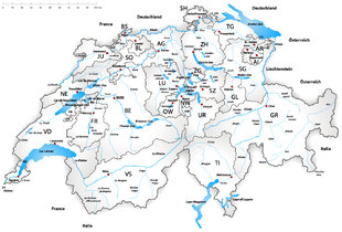
Rivers in Switzerland
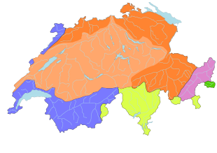
according to mean discharge (over 30 m³ / s)

according to mean discharge (over 30 m³ / s)

This list shows the largest rivers in Switzerland without claiming to be exhaustive.
The largest rivers in Switzerland
| Surname | Length in km |
Catchment area in km² (2) |
mean discharge ( MQ ) in m³ / s |
High flow rate ( MHQ ) in m³ / s |
Area code according to HADES |
|---|---|---|---|---|---|
| Rhine | 375 | 36,472 | 1037 | 10 | |
| Rhine above Aare | 315 | 15,944 | 457 (3) | ||
| Aare | 288.2 | 17'755 | 560 | 20 (2) | |
| Aare ob. Reuss | 273 | 11,729 | 315 | ||
| Rhone (fr: Rhône, German also: Rotten) | 264 | 10,427 | 340 | 973.2 | 50 |
| Reuss | 158 | 3425 | 140 | 30 (2) | |
| Orbe / Zihl | 118 | 2672 | 55.5 | ||
| Linth / Limmat | 140 | 2416 | 101 | 40 (2) | |
| Inn (Raetorom .: En) | 104 | 2150 | 53.3 | 272.6 | 80 |
| Saane (fr: Sarine) | 128 | 1892 | 53.8 | ||
| Thur | 125 | 1724 | 47 | ||
| Hinterrhein (4) | 57.3 | 1693 | 59.6 | ||
| Ticino (German: Ticino) | 91 | 1616 | 67.9 | 895.5 | 60 |
| Anterior Rhine (4) | 67.5 | 1514 | 53.8 | ||
| Doubs | 74 | 1310 | 33.1 | 231.2 | |
| Kander | 44 | 1126 | 42.6 | 124.8 |
Evidence of catchment areas: Rhine, Rhone, Aare
Evidence of flood discharge values (MHQ: mean value of annual maxima): Rhone (without La Laire), Inn (5 km from the national border), Ticino, Kander (without Stadelbach), Doubs
Remarks:
- (1) The HADES river basins cover over 1000 km², but the small catchment areas Adda (70) and Etsch / Adige (90) are excluded as a river basin for hydrographic reasons (Adda to the Po → Adria, Etsch directly to the Adriatic)
- (2) The information relates to the entire catchment area (including outside of Switzerland) either at the point of confluence or at the point at which the river leaves Switzerland.
- (3)The Aare is (nominally) a tributary of the Rhine, but at its confluence with the Rhine it carries more water at 560 m³ / s than the latter with 458 m³ / s (sum of the Rekingen level value and the Wutach mouth value ). Reuss and Limmat are tributaries of the Aare - they are designated as a separate area because of their importance for Switzerland. The Linth is the upper reaches of the Limmat.
- (4) The Vorderrhein and Hinterrhein are the source rivers of the Rhine.
Tributaries, catchment area and water volume
- Length over 50 km or catchment area over 500 km² within Switzerland. The mean flow rate (MQ) according to the information in the info box in the article on the river is specified as the flow rate.
- Rhine (Switzerland only) - 375 km - 36'472 km² - 1037 m³ / s - (total data: length 1238.8 km, catchment area with Maas 218,300 km², discharge at the German-Dutch border 2300 m³ / s,total river system of the Rhine : 2900 m³ / s)
-
- Vorderrhein (source river of the Rhine) - 67.5 km - 1514 km² - 53.8 m³ / s
- Hinterrhein (source river of the Rhine) - 57.3 km - 1693 km² - 59.6 m³ / s
- Albula - 36 km - 950 km² - 29.1 m³ / s
- Alpine Rhine (Tamins - Lake Constance) - 90 km - 6119 km² - 235 m³ / s
- Landquart 43 km - 618 km² - 25 m³ / s
- Upper Rhine (Bodensee - Basel) - discharge increase: from 364 m³ / s (outflow Bodensee ) to 1037 m³ / s
-
- Thur 125 km - 1724 km² - 47 m³ / s
- Sitter 70 km - 340 km² - 10.2 m³ / s
- Töss - 57 km - 442 km² - 9.74 m³ / s
- Birs (fr: La Birse) - 73 km - 924 km² - 15.4 m³ / s
- Aare - 295 km - 17,755 km² - 560 m³ / s
-
- Kander - 44 km - 1126 km² - 42.6 m³ / s
- Simme - 53 km - 594 km² - 21.1 m³ / s
- Saane (fr: La Sarine) - 128 km - 1892 km² - 53.8 m³ / s
- Orbe / Zihl - 118 km - 2672 km² - 55.5 m³ / s
- Broye - 72 km - 854 km² - 12.3 m³ / s
- Emme - 81.9 km - 983 km² - 20 m³ / s
- Reuss - 164.4 km - 3425 km² - 140 m³ / s
- Kleine Emme - 58 km - 477 km² - 14.3 m³ / s
- Limmat - 36.3 km (total 140 km - 2416 km²) - 101 m³ / s
- Rhone (fr: Rhône, Rotten) (Switzerland only) - 264 km - 10'427 km² - 340 m³ / s - (total data: length 812 km, catchment area 95,500 km², discharge 1800 m³ / s into the Mediterranean )
- Ticino (German: Ticino) (Switzerland only) - 91 km - 1616 km² - 68 m³ / s (total data: length 248 km, catchment area 7228 km², discharge 348 m³ / s into the Po )
- Inn (Rätorom .: En) (Switzerland only) - 104 km - 2150 km² - 58 m³ / s (total data: length 517 km, catchment area 26130 km², discharge 740 m³ / s into the Danube )
See also
- List of lakes in Switzerland
- List of the largest lakes in Switzerland
- List of mountains in Switzerland
- List of valleys in Switzerland
- List of Swiss glaciers
Web links
Individual evidence
- ↑ Current situation waters. BFU, accessed on January 10, 2014 .
- ↑ Hydrological Yearbook of Switzerland. (PDF) FOEN, accessed on January 10, 2014 .
- ↑ Provisional data: Rhine - Weil, Palmrainbrücke. (PDF) BFU, accessed on January 10, 2014 .
- ↑ Provisional data: Rhône - Chancy, Vers Vaux. (PDF) BFU, accessed on January 10, 2014 .
- ↑ Provisional data: Aare - Felsenau, KW Klingnau (UW). (PDF) BFU, accessed on January 10, 2014 .
- ↑ Rhône - Chancy, Aux Ripes - BD-No 672 - Probabilité des crues (pointes annuelles). (PDF) BFU, accessed on January 10, 2014 .
- ↑ Inn - Martina - DB no. 210 - flood probabilities (annual flood). (PDF) BFU, accessed on January 10, 2014 .
- ↑ Level data from Bellinzona, Hydrological Yearbook of Switzerland. (PDF) FOEN, accessed on January 10, 2014 .
- ↑ Kander - Hondrich - DB no. 1117, flood probabilities (annual flood). (PDF) BFU, accessed on January 10, 2014 .
- ↑ Level data from Ocourt, Hydrological Yearbook of Switzerland. (PDF) FOEN, accessed on January 10, 2014 .

