
Sihl
| Sihl | ||
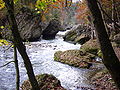
 The Sihl near Sihlwald |
||
| Data | ||
| Water code | CH : 577 | |
| location | Switzerland | |
| River system | Rhine | |
| Drain over | Limmat → Aare → Rhine → North Sea | |
| source | on the Drusberg at the junction of two source streams 47 ° 0 ′ 25 ″ N , 8 ° 51 ′ 9 ″ E |
|
| Source height | 1872 m above sea level M. | |
| muzzle | at Platzspitz in the Limmat Coordinates: 47 ° 22 '58 " N , 8 ° 32' 17" E ; CH1903: 683 029 / 248567 47 ° 22 '58 " N , 8 ° 32' 17" O |
|
| Mouth height | 402 m above sea level M. | |
| Height difference | 1470 m | |
| Bottom slope | 21 ‰ | |
| length | 69 km | |
| Catchment area | 344.26 km² | |
| Discharge at Sihlhölzli Zurich A Eo gauge : 343 km² Location: 2.1 km above the mouth |
NNQ (1950) MNQ 1938–2016 MQ 1938–2016 Mq 1938–2016 MHQ 1938–2016 HHQ (2005) |
750 l / s 3.69 m³ / s 6.8 m³ / s 19.8 l / (s km²) 10.4 m³ / s 280 m³ / s |
| Left tributaries | Alp , minster | |
| Right tributaries | Schanzengraben | |
| Reservoirs flowed through | Sihlsee | |
 |
||
The Sihl is a Swiss river and the largest tributary of the Limmat . It drains parts of the Schwyz Pre-Alps and then flows in a narrow corridor south of Lake Zurich and north resp. east of the catchment area of the Reuss and Reppisch to the northwest of the city of Zurich , where it flows into the Limmat. The Sihl is 69 kilometers long and drains an area of 341 square kilometers.
The name of the river comes from the Celtic and means the strong .
course

The Sihl rises on the northeast slope of the Drusberg between Höch Hund and Mieserenstock in the canton of Schwyz south of Studen and east of the Hoch-Ybrigs .
At Einsiedeln it is dammed together with the somewhat larger Minster to form Sihlsee , the largest reservoir in Switzerland with a surface area of 11 km² . Below the dam, the Sihl carries 0.3 m³ / s to 0.4 m³ / s, or 2.5 m³ / s to 3.0 m³ / s at the Zurich canton border, according to the concession. An average of 88% of the natural inflow could thus be used for energy generation. This water is fed through the Etzel via a pressure pipe to Altendorf SZ into the power plant and from there into Lake Zurich. Where the Sihlsee is located today, there was a natural lake of even larger area 15,000 years ago.
A little below the dam, the Sihl at Egg SZ is crossed by the Teufelsbrücke , over which the Jakobsweg connects Pfäffikon SZ and the Etzelpass with Einsiedeln. Paracelsus was born right next to her in 1493 .
An important tributary is the Alp , which flows into Biberbrugg . A little below Schindellegi , the Sihl leaves the canton of Schwyz, flows a little through the canton of Zurich and then borders it from Hütten to Sihlbrugg towards the canton of Zug . In this section there are rapids near Schönenberg , the so-called Sihl jump .
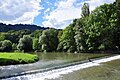
From Sihlbrugg, the Sihl flows through the Zurich Sihltal , which is accompanied on the left by the Albis mountain range and on the right by the flatter hills of the Zimmerberg . Between Sihlbrugg and Langnau am Albis lies the Sihlwald , a nature reserve owned by the city of Zurich and formerly the city forest, which was important for the city's wood supply. The route above Sihlbrugg was less suitable for the Holztrift , so that it always resulted in high losses. Then the Sihl passes Adliswil and reaches the city of Zurich near Leimbach . In this section it loses a large part of its water, since in the 19th century many factories secured a right to use water “for ever”, for energy generation or as process water. Numerous corrections to the river bed reduced the high flow velocity during this time.
In Zurich-Brunau, a city motorway, the Sihl hochstrasse of the A3 , lies on bridges across the river . From the Sihlhölzli the water flows open again and is crossed by the Stauffacher Bridge along with others . Over the last hundred meters, it joins the water of the Schanzengraben , a remnant of the moat of the southern city fortifications of Zurich. Then it runs under the 16 above-ground tracks of the main train station and flows into the Limmat at Platzspitz near the state museum .
Earlier muzzle arms
The Sihl used to transport 18,000 cubic meters and more debris per year from the Alps to the area of the city of Zurich, where these deposits shaped the subsoil. In prehistoric times, the Sihl delta did not only encompass today's confluence with the Limmat, but also extended south of the Lindenhof hill with many estuary arms that poured into Lake Zurich.
In the 1st millennium BC, the debris brought in by the Sihl dammed up the Limmat's drainage. As a result, the level of Lake Zurich rose significantly. At that time, large areas on today's bank were likely to have been alluvial areas, including the entire upper Bahnhofstrasse and Paradeplatz . By removing the debris at the mouth of the Sihl into the Limmat in Roman times , the water level of Lake Zurich sank sharply, which is why at that time buildings could be built in areas that are flooded again today. Back then, too, an arm of the Sihl flowed into the Limmat near the Münsterhof .

In late or post-Roman times, no more rubble was removed, the lake level rose again quickly for several centuries and again several arms of the Sihl poured into Lake Zurich. During the early Middle Ages , the Sihl was regulated again. At least since the year 853, when the Fraumünster was founded, the lake level must have been at today's level. Since then, all Sihl water has been channeled north of the Lindenhof hill into the Limmat, and accumulating debris has been removed.
A Sihlarm - called in sources from the 15th century in contrast to the main arm Wilde Sihl Zahme Sihl , later Sihl Canal - was still routed through the city fortifications and over the Schanzengraben into the city center north of the Rennweg until the 20th century . It drove water wheels in the city and flowed into the Limmat at the Gedeckten Brüggli .
Industrial use
In the past, the Sihl was used to flow wood from the Sihlwald into the city . Numerous factories were later built along the river that used the river's hydropower as an energy source. Several hydropower plants were also built in the 20th century.
bridges
Over 70 bridges cross the Sihl.
Flood risk
The last major flood in the city of Zurich due to the Sihl occurred in 1910. The city is still in great danger: Severe storms in the Schwyz Prealps could lead to flooding in Zurich. If the Sihlsee dam breaks, parts of the city of Zurich would be flooded several meters high. The tidal wave would reach the upper city limit in Leimbach after one and a half hours, the city center after just under two and the lower city limit near Altstetten after just under three hours. A flood would have enormous damage potential in the city of Zurich, but also in the Limmattal and Sihl valleys.
There were several options up for discussion that could provide relief in emergencies: an enlargement of the pressure tunnel of the Etzel dam , which - in addition to generating electricity - would make Lake Sihl into a large retention basin, and a relief tunnel between Langnau am Albis and Lake Zurich. The latter is to be implemented by 2024. It is around two kilometers long, only fills up during floods and is supposed to divert around 300 cubic meters of water per second into Lake Zurich.
A huge driftwood rake was completed in 2017 in the Sihlwald at a sharp bend in the river. The 350 meter long rake is secured in the lower part with 68 to 4.5 meter high, massive steel posts. It holds 12,000 tons of driftwood, around 1,200 truckloads. The purpose of the rake is to prevent wood that has been swept away, including whole tree trunks, from wedging itself on a bridge, creating a barrier and thus causing a flood.
Any extreme flooding of the Sihl threatens to submerge Zurich's main train station - especially the underground through stations. The SBB plan to prevent the water from penetrating with hose dams at Europaallee that are filled with water.
photos

Sihlsee
Sihl below the Sihl jump
In Zurich-Brunau

Sihl and Sihl high street in Zurich-Brunau
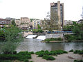
Confluence with the Limmat (at the back) in Zurich


Web links
- Martin Illi: Sihl. In: Historical Lexicon of Switzerland .
- Sihlsee
- Sihlsee flood zone (PDF; 396 kB)
- Primordial topography and lake level fluctuations
- Holztrift auf der Sihl - two articles (PDF; 1.5 MB)
Individual evidence
- ↑ a b Geoserver of the Swiss Federal Administration ( information )
- ↑ Evaluations of the water network. (XLSX) FOEN , December 2013, accessed on August 9, 2017 (listing of Swiss rivers> 30km).
- ↑ Modeled mean annual discharge. In: Topographical catchment areas of Swiss waters: sub-catchment areas 2 km². Retrieved August 9, 2017 .
- ↑ Sihlhölzli measuring station in Zurich 1938–2016 (PDF) Federal Office for the Environment FOEN
- ↑ Sihl Bridge. In: Gang dur Züri. Retrieved October 26, 2010 .
- ↑ Etzelwerk 2006. (PDF; 947 kB) Retrieved on October 25, 2010 .
- ↑ Ur-Sihlsee. In: Sihlsee.ch.vu. Retrieved October 25, 2010 .
- ↑ Horticultural Office of the City of Zurich on the Sihlwald ( Memento of the original from April 16, 2013 in the Internet Archive ) Info: The archive link was inserted automatically and has not yet been checked. Please check the original and archive link according to the instructions and then remove this notice.
- ^ Daniel Bitterli: Rafting on the Sihl between the Einsiedeln and Zurich region . In: Historischer Verein Zentralschweiz (Hrsg.): Der Geschichtsfreund . No. 161 . Lucerne 2008, p. 63–75 ( copy of the article [PDF]).
- ↑ Dölf Wild: Zurich City under water - interaction between nature and people in Zurich's early days . In: City of Zurich, Office for Urban Development (Ed.): Archeology and Monument Preservation. Report 2006–2008 . gta Verlag, Zurich 2008, ISBN 978-3-85676-238-4 , p. 21–23 ( online version, PDF, 507 kB ).
- ↑ Copper engraving (possibly 1834) The battle of St. Jakob an der Sihl d. July 22, 1443
- ^ Canton of Zurich: Flood protection concepts for Sihl, Lake Zurich and Limmat
- ↑ Protection and Rescue City of Zurich (PDF; 396 kB)
- ↑ a b [1] Stefan Hotz: The flood tunnel has the ETH seal . In: Neue Zürcher Zeitung . No. 66 , March 20, 2019, p. 17 .
- ↑ Adi Kälin: The Sihl remains a wild river . In: Neue Zürcher Zeitung . No. 146 , June 27, 2015, p. 16 ( article online ).
- ↑ How a tunnel through Zimmerberg is supposed to protect Zurich In: Tagesanzeiger of March 19, 2019
- ↑ Stefan Hotz: Flood protection: Zurich is now safer In: Neue Zürcher Zeitung of June 22, 2017
- ↑ SBB rehearsing an emergency: flood exercise on Europaallee In: Limmataler Zeitung of August 8, 2019
Rivers with a total length of more than 30 km:
Aare |
Albula |
Allaine |
Old Rhine |
Arbogne |
Areuse |
Swiss stone pine |
Birs |
Brenno |
Broye |
Calancasca |
Doubs |
Drance de Bagnes |
Thinning |
Emme |
Engelberger Aa |
Ergolz |
Glâne |
Smooth |
Glenner (Glogn) |
Hinterrhein |
Inn (En) |
Julia (Gelgia) |
Kander |
Little Emme |
Landquart |
Land water |
Langete |
Limmat |
Linth |
Lorze |
Maggia |
Mentue |
Moësa |
Muota |
Murg |
Necker |
Orbe |
Petite Glâne |
Plessur |
Rabiusa |
Reuss |
Rhine |
Rhone |
Saane |
Schüss (Suze) |
Seez |
Scythe |
Sihl |
Simme |
Sitter |
Sorne |
Suhre |
Talent |
Tamina |
Ticino (Ticino) |
Thur |
Töss |
Venoge |
Verzasca |
Vispa |
Vorderrhein |
Wigger |
Wyna