
Little Emme
| Little Emme | ||
 Course of the Kleine Emme |
||
| Data | ||
| Water code | CH : 707 | |
| location | Switzerland | |
| River system | Rhine | |
| Drain over | Reuss → Aare → Rhine → North Sea | |
| confluence | from Waldemme and Weissemme near Schüpfheim 46 ° 56 ′ 26 ″ N , 8 ° 0 ′ 24 ″ E |
|
| Source height | 727 m above sea level M. | |
| muzzle | northwest of the city of Lucerne in the Reuss Coordinates: 47 ° 4 ′ 2 ″ N , 8 ° 17 ′ 15 ″ E ; CH1903: 664.49 thousand / 213 246 47 ° 4 '2 " N , 8 ° 17' 15" O |
|
| Mouth height | 430 m above sea level M. | |
| Height difference | 297 m | |
| Bottom slope | 8.3 ‰ | |
| length | 36 km | |
| Catchment area | 478.35 km² | |
| Discharge at the Werthenstein gauge , Chappelboden A Eo : 311 km² |
NNQ (2011) MNQ 1985–2016 MQ 1985–2016 Mq 1985–2016 MHQ 1985–2016 HHQ (2005) |
950 l / s 7.24 m³ / s 11 m³ / s 35.4 l / (s km²) 14.7 m³ / s 470 m³ / s |
| Discharge at the Emmen A Eo gauge : 478 km². Location: 920 m above the mouth |
NNQ (2005) MNQ 1978–2016 MQ 1978–2016 Mq 1978–2016 MHQ 1978–2016 HHQ (2005) |
1.29 m³ / s 10.2 m³ / s 15.5 m³ / s 32.4 l / (s km²) 20.5 m³ / s 650 m³ / s |
 Wooden bridge over the Kleine Emme near Im Bad , Wolhusen |
||

| ||
Source and mouth of the Kleine Emme
|
The Kleine Emme is a roughly 36 kilometers long left tributary of the Reuss in the Swiss canton of Lucerne . It arises from the confluence of the Waldemme and Weissemme (Wissemme) near Schüpfheim , flows through the Entlebuch and flows into the Reuss between Lucerne and Emmen . Together with the Waldemme , its length is 59.5 km, its catchment area measures around 478 km² and its mean discharge is 15.5 m³ / s.
course
The Kleine Emme is created by the confluence of the left source river Weissemme and the right source river Waldemme at 727 m above sea level. M. near Bad in the community of Schüpfheim. The longer Waldemme has a catchment area of 115 km², while that of the Wissemme measures only 29.2 km².
It flows first to the north-northeast through the wide, open valley of the Entlebuch, separating the hilly Napf in the north-west from the pre-Alps in the south-east. The lower part of this section is partially cut like a gorge into the Nagelfluh and sandstones of the region. At Wolhusen, the Kleine Emme makes a sharp bend to the east and now flows parallel to the Pilatus range , the valley gradually opening up and from Malters onwards forming a flat valley floor about 1 km wide. The Kleine Emme flows into the Reuss around 2 km northwest of the city of Lucerne .
The most important tributaries from the right from the foothills of the Alps are the Entlen , which flows out at Entlebuch , and the Rümlig . The Fontanne collects the water from the eastern Napf area and feeds it to the Kleine Emme south of Wolhusen. Other tributaries of the Kleine Emme are the Chesselbach and the Ränggbach.
Flood
The floods of the Kleine Emme after prolonged rainfall or strong thunderstorms are feared mainly in the area between Schüpfheim and Wolhusen. They repeatedly caused major damage. The course of the Waldemme is largely natural to near-natural. In the middle reaches of the Kleine Emme, sewers were sometimes necessary, but there are also longer natural sections with floodplains and extensive gravel banks between Entlebuch and Wolhusen. The lower reaches of the Kleine Emme were canalized to protect the flat valley floor from flooding.
bridges
On its way, the Kleine Emme is spanned by over 40 road, rail and pedestrian bridges.
Five covered wooden bridges cross the river, whereby the moat bridge in Hasle (1782) and the village bridge (1775) in Werthenstein are buildings worthy of protection.
Flood protection measures, in particular the expansion of the Kleine Emme with a second channel in the estuary , required the construction of seven new bridges in the years 2013-2017, ie three road, two railway and two non-motorized bridges.
Special
In the 18th century gold was panned in the Kleine Emme . Today the waterway adventure path Kleine Emme with display boards leads between Hasle and Wolhusen along the course of the river.
Little Emme; Railway bridge at Werthenstein
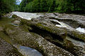
The Chalchloch - here the Kleine Emme has dug its way through 10 million year old layers of Nagelfluh

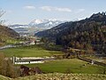
Meadow landscape of the Kleine Emme near Entlebuch

The Waldemme below the confluence of the Steinibach


Web links
- Project: Flood protection and renaturation of the Kleine Emme
- Anne-Marie Dubler : Emme. In: Historical Lexicon of Switzerland .
Individual evidence
- ↑ a b Geoserver of the Swiss Federal Administration ( information )
- ↑ Evaluations of the water network. (XLSX) FOEN , December 2013, accessed on July 21, 2018 (listing of Swiss rivers> 30km).
- ↑ Swisstopo / BAFU , Karte Vektor25 water network with measuring function, section with the Kleine Emme and its source rivers
- ↑ Topographical catchment areas of Swiss waters: sub-catchment areas 2 km². Retrieved July 21, 2018 .
- ↑ Kleine Emme - Werthenstein, Chappelboden. (PDF) In: Federal Office for the Environment. Retrieved July 21, 2018 .
- ↑ Kleine Emme - Emmen. (PDF) In: Federal Office for the Environment. Retrieved July 21, 2018 .
Rivers with a total length of more than 30 km:
Aare |
Albula |
Allaine |
Old Rhine |
Arbogne |
Areuse |
Swiss stone pine |
Birs |
Brenno |
Broye |
Calancasca |
Doubs |
Drance de Bagnes |
Thinning |
Emme |
Engelberger Aa |
Ergolz |
Glâne |
Smooth |
Glenner (Glogn) |
Hinterrhein |
Inn (En) |
Julia (Gelgia) |
Kander |
Little Emme |
Landquart |
Land water |
Langete |
Limmat |
Linth |
Lorze |
Maggia |
Mentue |
Moësa |
Muota |
Murg |
Necker |
Orbe |
Petite Glâne |
Plessur |
Rabiusa |
Reuss |
Rhine |
Rhone |
Saane |
Schüss (Suze) |
Seez |
Scythe |
Sihl |
Simme |
Sitter |
Sorne |
Suhre |
Talent |
Tamina |
Ticino (Ticino) |
Thur |
Töss |
Venoge |
Verzasca |
Vispa |
Vorderrhein |
Wigger |
Wyna