
Brenno (river)
|
Brenno upper name: Brenno della Greina |
||
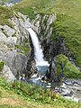
 The Brenno in Olivone |
||
| Data | ||
| Water code | CH : 55 | |
| location | Switzerland | |
| River system | Po | |
| Drain over | Ticino → Po → Mediterranean | |
| source | at Piz Gaglianera 46 ° 37 ′ 18 ″ N , 8 ° 57 ′ 15 ″ E |
|
| Source height | approx. 2710 m above sea level M. | |
| muzzle | at Biasca in the Ticino coordinates: 46 ° 21 '24 " N , 8 ° 57' 14" E ; CH1903: 716 628 / 135034 46 ° 21 '24 " N , 8 ° 57' 14" O |
|
| Mouth height | 287 m above sea level M. | |
| Height difference | approx. 2423 m | |
| Bottom slope | approx. 67 ‰ | |
| length | 36 km | |
| Catchment area | 407.47 km² | |
| Discharge at the mouth of A Eo : 407.47 km² |
MQ Mq |
17.62 m³ / s 43.2 l / (s km²) |
| Left tributaries | Orino , Lesgiuna | |
| Right tributaries | Fiume d'Oràira , Brenno di Santa Maria | |

| ||
Source and mouth of the Brenno |
The Brenno is a 36 km long river in the canton of Ticino in Switzerland . It flows through the Blenio valley in a predominantly southerly direction and flows into Ticino at Biasca .
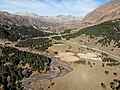
The main source river of the Brenno rises below the Piz Gaglianera in the Cogn dei Lavazz area . It flows through the valley portion Val Camadra takes at Campo the outflow of the lake Lago di Luzzone and joins in the basin of Olivone with the Lukmanierpass down flowing Brenno di Santa Maria .
In the lower reaches - between Malvaglia and the rockslide cone Buzza di Biasca - the Brenno is very overgrown. Its gravel deposits and those of its left tributaries Orino and Lesgiüna take up the entire width of the valley floor.

Map of the Blenio Valley from the Geographical Lexicon of Switzerland (1902)
As a mountain stream in the upper reaches of the Val Camadra

Brenno at Motto-Ludiano
Alpe Casaccia

at the Alpe Casaccia


Web links
- Christophe Bonnard: Buzza di Biasca. In: Historical Lexicon of Switzerland .
Individual evidence
- ↑ a b Geoserver of the Swiss Federal Administration ( information )
- ↑ Evaluations of the water network. (XLSX) FOEN , December 2013, accessed on June 9, 2017 (listing of Swiss rivers> 30km).
- ↑ a b Modeled mean annual discharge. In: Topographical catchment areas of Swiss waters: sub-catchment areas 2 km². Retrieved May 30, 2019 .
Rivers with a total length of more than 30 km:
Aare |
Albula |
Allaine |
Old Rhine |
Arbogne |
Areuse |
Swiss stone pine |
Birs |
Brenno |
Broye |
Calancasca |
Doubs |
Drance de Bagnes |
Thinning |
Emme |
Engelberger Aa |
Ergolz |
Glâne |
Smooth |
Glenner (Glogn) |
Hinterrhein |
Inn (En) |
Julia (Gelgia) |
Kander |
Little Emme |
Landquart |
Land water |
Langete |
Limmat |
Linth |
Lorze |
Maggia |
Mentue |
Moësa |
Muota |
Murg |
Necker |
Orbe |
Petite Glâne |
Plessur |
Rabiusa |
Reuss |
Rhine |
Rhone |
Saane |
Schüss (Suze) |
Seez |
Scythe |
Sihl |
Simme |
Sitter |
Sorne |
Suhre |
Talent |
Tamina |
Ticino (Ticino) |
Thur |
Töss |
Venoge |
Verzasca |
Vispa |
Vorderrhein |
Wigger |
Wyna