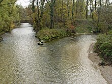
Sorne
The Sorne is a 31 km long left tributary of the Birs in the northern Jura . With a catchment area of 209 km², the Sorne makes up 23% of the entire catchment area of the Birs and is one of its most important tributaries.
geography
course
The Sorne rises on the soil of the canton of Jura on the eastern edge of the Franches-Montagnes (German Freiberge ) in the high Jura in the municipality of Les Genevez . First it flows through the Petit Val , a longitudinal valley in the Jura, to the east, before it makes a sharp bend to the north below Sornetan and takes in the Tchaïbez brook from the right . Now it breaks through the anticline of the Jura chain of the Montagne de Moutier in a typical clus . This transverse valley, the Gorges du Pichoux , has distinctive rock walls and layers that reveal the fold structure of the chain Jura. In this 2 kilometer long gorge, the Sorne loses 200 meters of altitude and crosses into the area of the canton of Jura .
To the north of the Pichoux Gorge, the Sorne flows through the Undervelier basin with the Grotte de Sainte-Colombe .
The Ruisseau de Soulce (Sulzbach) flows here from the right . Immediately below the village, the Sorne has created another clus, it breaks through the anticline of Le Mont and has around 500 m high valley flanks on both sides.
At Bassecourt , the Sorne enters the wide valley of the Delsberg basin and turns its course to the east. Here it takes in the Tabeillon from the west , the longest side stream that comes from the Freiberg mountains. The Sorne flows with numerous bends through the flat floodplain of the Delsberg basin and through the town of Delémont , before it flows into the Birs northeast of the town.
Source and mouth of the Sorne
|
Catchment area
The catchment area of the Sorne is 217.65 km² and consists of 45.8% forest land , 47.1% agricultural area and 6.6% settlement area .

The mean height of the catchment area is 771 m above sea level. M. , the minimum height is 404 m above sea level. M. and the maximum height at 1333 m above sea level. M.
Tributaries
- La Rouge Eau ( right )
- Ruisseau Sagnes Jaques ( left )
- Ruisseau les Sagnes ( right )
- Sous le Beucle ( left )
- La Drais ( left )
- L'Sagne ( right )
- Le Pichoux ( right )
- Le Folpotat ( Ruisseau de Soulce ) ( right )
- Le Miéry ( left )
- Ruisseau du Biernol ( right )
- Le Tabeillon ( left )
- Ruisseau de Boécourt ( left )
- La Rouge Eau ( left )
- Ruisseau des Grosses Aingles ( left )
- Grosses Aingles ( right )
- Ruisseau des Esserts ( left )
- Petites Aingles ( right )
- La Tuilerie ( Ruisseau de Courfaivre ) ( right )
- Ruisseau de Chételay ( right )
- Ruisseau de Limaces ( right )
- Ruisseau du Sâcy ( right )
- Bief de Châtillon ( right )
- Ruisseau de Rossemaison ( right )
- La Pran ( Ruisseau de Develier ) ( left )
- Le Ticle ( left fork )
- Golatte ( left )
Hydrology
At the confluence of the Sorne and the Birs, its modeled mean discharge rate (MQ) is 4.59 m³ / s. Her discharge regime type is pluvial jurassia, and her discharge variability is 26.
The flow rate of the Sorne fluctuates relatively strongly over the course of the year. The highest water levels were determined for the months of December to April. The flow rate reached its peak in April at 7.18 m³ / s. After that, the discharge fell slightly month after month until April and then sharply and reached its lowest level in August at 1.71 m³ / s, only to then increase again from month to month.
The modeled monthly mean discharge (MQ) of the Sorne in m³ / s

character
The upper and middle reaches of the Sorne are mostly natural or natural, in the lower reaches they have been partially canalised. Part of the water seeps into the karstified, water-permeable limestone layers in the area of the upper reaches and reappears elsewhere as a karst spring , for example in the Blanches Fontaines in the Pichoux Gorge. The water power of the Sorne was used in the iron smelting works of Undervelier and with several mills.
bridges
On its way, the Sorne is spanned by over 60 bridges, worth mentioning are the Berlincourt stone arch bridge from 1865 in Bassecourt, the A16 motorway bridge from 2001/03 in Delémont and the historic Maltière stone arch bridge from the 15th century, also in Delémont.
Web links
Individual evidence
- ↑ a b Geoserver of the Swiss Federal Administration ( information )
- ↑ Evaluations of the water network. (XLSX) FOEN , December 2013, accessed on August 10, 2017 (listing of Swiss rivers> 30km).
- ↑ a b c Modeled mean annual discharge. In: Topographical catchment areas of Swiss waters: sub-catchment areas 2 km². Retrieved August 12, 2017 .
- ↑ Delémont measuring station 1983–2016 (PDF) Federal Office for the Environment FOEN
- ↑ "Hidden behind the mean values" - the variability of the discharge regime , p. 7
- ↑ The discharge variability describes the extent of the fluctuations in the mean discharge of individual years around the long-term mean discharge value.


