
Delémont
| Delsberg Delémont |
|
|---|---|
 |
|
| State : |
|
| Canton : |
|
| District : | Delémont |
| BFS no. : | 6711 |
| Postal code : | 2800 |
| UN / LOCODE : | CH DEL |
| Coordinates : | 592 827 / 246044 |
| Height : | 435 m above sea level M. |
| Height range : | 394–930 m above sea level M. |
| Area : | 21.97 km² |
| Residents: | 12,682 (December 31, 2018) |
| Population density : | 577 inhabitants per km² |
| City President : | Pierre Kohler ( CVP ) |
| Website: | www.delemont.ch |
 Delémont |
|
| Location of the municipality | |
  |
|
Delsberg ( French Delémont ([ dəlemɔ ], regional [ dlemɔ ]), Italian Delemonte , Romansh Delemunt , medieval Latin Delemons ) is a municipality and the capital of the Swiss canton of Jura as well as its district Delsberg .
geography
location
Delsberg lies at 435 m above sea level. M. , 28 km southwest of Basel (air line), about halfway between Basel and Biel / Bienne . The city stretches on both sides of the Sorne , shortly before its confluence with the Birs on the northern edge of the Delsberg basin , a broad depression in the northern Jura .
Municipal area
The area of the 22.03 km² large municipal area comprises a section in the central part of the agriculturally intensively used plain of the Delsberg basin. The southern part of the municipality includes the flat lowlands on the Sorne and the Birs and extends in the far south to the slope of the Montchaibeux , an isolated hill in the basin. To the north the area extends to the anticline of the Les Rangiers chain and reaches the highest point of Delémont in the Plain de la Chaive ( 930 m above sea level ). The northern border forms the valley of the Mettembert brook, which flows into the Birs at Soyhières . The eastern border mostly runs along the Birs. This breaks through the anticline of the Les Rangiers chain northeast of Delsberg in a typical Jura cross valley, the Klus von Vorbourg, of which the western valley flank still belongs to the municipality. In 1997, 18% of the municipal area was in settlements, 43% in forests and woodlands, 38% in agriculture and a little less than 1% was unproductive land.
The village of Les Rondez ( 415 m above sea level ) between Sorne and Birs, the hamlet of Les Vorbourgs ( 521 m above sea level ) on the western flank of the valley of the same name as well as numerous individual farms belong to Delémont .
Neighboring communities
The neighboring communities of Delémont are Develier , Courtételle , Rossemaison , Courrendlin , Courroux , Soyhières , Mettembert and Bourrignon .
Climate table
| Delsberg, 1981-2010 | ||||||||||||||||||||||||||||||||||||||||||||||||
|---|---|---|---|---|---|---|---|---|---|---|---|---|---|---|---|---|---|---|---|---|---|---|---|---|---|---|---|---|---|---|---|---|---|---|---|---|---|---|---|---|---|---|---|---|---|---|---|---|
| Climate diagram | ||||||||||||||||||||||||||||||||||||||||||||||||
| ||||||||||||||||||||||||||||||||||||||||||||||||
|
Average monthly temperatures and rainfall for Delémont, 1981–2010
Source:
|
||||||||||||||||||||||||||||||||||||||||||||||||||||||||||||||||||||||||||||||||||||||||||||||||||||||||||||||||||||||||||||||||||||||||||||||||||||||
population
| Population development | |
|---|---|
| year | Residents |
| 1770 | 921 |
| 1850 | 1650 |
| 1880 | 2793 |
| 1900 | 5053 |
| 1910 | 6161 |
| 1930 | 6393 |
| 1950 | 7504 |
| 1960 | 9542 |
| 1970 | 11797 |
| 1980 | 11682 |
| 1990 | 11548 |
| 2000 | 11353 |
| 2010 | 11590 |
With 12,682 inhabitants (as of December 31, 2018), Delsberg is the largest municipality in the canton of Jura in terms of population. 84.3% of the residents are French-speaking, 4.0% Italian-speaking and 3.1% German-speaking (as of 2000). In 2000, 70% of the population were Catholic , 13% Reformed , while the rest were either non-denominational or of other faiths.
economy
Already in 1770 Delsberg had an urban employment structure despite the small population. At that time around 25% of the working population were employed in agriculture , around 50% in handicrafts (mainly wood and iron crafts, textile trades, leather processing, millers, bakers, butchers) and the remaining 25% earned their living through trade or other self-employed people Jobs.
Industrialization began in the first half of the 19th century . In the beginning, iron processing was of particular importance, in 1838 the forge company of Bellefontaine (Saint-Ursanne) founded a blast furnace and a foundry. Towards the end of the 19th century the watch industry, the manufacture of watch cases, mechanical engineering as well as cigar and cement factories also gained a foothold in Delémont.
Today Delémont is a regional economic center that performs central functions for the entire canton of Jura and the adjacent areas of the Bernese Jura . The most important employers in the secondary sector include companies in the machine and metal industry, the knife and watch industry ( Wenger ), electronics, the textile industry and the construction industry. The canton and district administrations are also located in the city. There are numerous other jobs in banking and insurance as well as in social and medical institutions (regional hospital).
Healthcare
The city has a public hospital with 24-hour emergency care. It is part of the hospital network of the Hôpital du Jura .
Culture, education and sport
Since 1909, Delémont has housed the Museum of Jurassic Art and History (Musée Jurassien d'Art et d'Histoire), which exhibits a collection of the history of the Jurassic from the Romans and Merovingians to the recent past. A crook from the 7th century, a goldsmith's work of southern German origin, is unique.
There are also two community libraries, a toy library, the Jura music school and a regional cultural center. Delsberg is also an educational center with a higher commercial school (opened in 1911) and a commercial vocational school as well as the canton school.
With around 200 official clubs (i.e. one club for every 56 inhabitants), the town has the highest number of clubs in Switzerland. The La Blancherie sports center was inaugurated in 1986. It is used by numerous sports clubs.
traffic
Road traffic
The city lies at the junction of the main roads from Basel to Biel and to La Chaux-de-Fonds . In 1998 the first section of the A16 motorway was opened on Jurassic soil with the route Delémont - Pruntrut . In 2005 the bypasses of Delsberg and Pruntrut followed. The A16 has been connected to both the Swiss national road network and the French motorway network since 2017.
Rail transport
On September 25, 1875, Delsberg was connected to the railway network with the Basel – Delsberg line, the Jura Railway. The continuation to Moutier was inaugurated on December 16, 1876, after the Delsberg – Glovelier line had already been opened on October 15, 1876 . The city is connected to the greater Basel area by the S3 line of the Basel S-Bahn ( Basel SBB - Pruntrut ). All trains on the Basel – Biel line have to change direction at Delsberg station . There are also direct RE trains to Meroux TGV (Belfort Montbelliard TGV) with a connection to the TGV to Paris.
During the Second World War , the railway stations of Delsberg, Bassecourt and Courrendlin were bombed several times by the Allies . Several railway employees died.
Bus routes
A bus network to the surrounding communities provides for the fine distribution of public transport: to Moutier, Lucelle , Pleigne , Roggenburg , Soyhières , Châtillon and Val Terbi ( Montsevelier ).
politics
The distribution of seats in the Delsberg city parliament (conseil de ville) for the 2018–2022 election period is shown in the diagram opposite.
history


The municipality of Delémont was already settled in the Bronze Age ; 15 urn graves are witnesses of this time. Traces of an Iron Age and a Gallo-Roman settlement are also preserved. Delémont is the first time in 737 as in figo Delemonze mentioned (in the village Delemonz) . In 1131 the German name Telsperc appears . Other name variants are Laimunt (1181) and Deleymunt (1225). The place name is a combination of the Germanic name Tallo or Tello with the Latin word mons 'Berg', whereby the morphosyntax (the type of word connection) is influenced by German.
Since the 7th century the area belonged to the estate of the Alsatian dukes. In the 12th century, the place was part of the Pfirt rule , which was bought in 1271 by the Bishop of Basel. Already at that time, the Delsberg, located on a ledge above the Sorne, was fortified. It was granted town charter on January 6, 1289 by a charter from Bishop Peter Reich von Reichenstein . This laid the foundation for the town's economic development. From 1289 to 1793 it was the main town of the Delsberg rule and in 1407 concluded a castle rights treaty with the city of Basel. For centuries Delsberg was the summer residence of the Basel prince-bishops. In the spirit of the Counter-Reformation, a Capuchin monastery and an Ursuline convent were founded in Delémont, both of which were closed in 1793. Members of the de Grandvillers family held various important positions in the city administration.
After the conquest by French troops in 1793, Delsberg became the capital of a district of the Département du Mont-Terrible ; this was incorporated into the department of Haut-Rhin in 1800 . As a result of the decision of the Congress of Vienna in 1815, the town came to the canton of Bern and took over the function of the capital of the district (until 1831 still Oberamt) of Delsberg. The canton of Bern was never really able to make friends with the new part, as it differed from the rest of the canton in terms of both language and denomination.
In the course of industrialization, the German-speaking population in Delsberg increased sharply and in 1880 reached a share of almost 40%. This made the city temporarily bilingual. In 1920 the German-speaking population began to emigrate and assimilate continuously.
In 1947, the government councilor Georges Möckli, from the French-speaking part of the canton, was refused to take over the education department. After this affront, the city developed into the center of the separatist movements in the Jura. The Festival of the Jurassic People ( Fête du peuple jurassien ) has been held every year since 1948 . In the referendums of 1959 and 1974, the residents voted with a large majority for the creation of the canton of Jura. Between 1976 and 1978, Delsberg was the meeting place for the draft constitution of the future canton. The city was chosen as the capital of the canton founded on January 1, 1979.
Urban development
The town, which was fortified at the beginning of the 14th century, had an almost square floor plan with two longitudinal and three cross streets. Delsberg was surrounded by a city wall with four gates: Porte Monsieur (or de Porrentruy ), Porte au Loup , Porte des Moulins and Porte des Prés (or de Bâle ). The episcopal castle was built in the 14th century in the south-west corner of the city, while the north-east corner was protected by a large round tower.
Until after 1800 there were only a few buildings outside the city wall. Then the quarter below the old town developed and with the construction of the train station (1875) a new focus of the settlement emerged here. Industry was mainly located south of the station and in Les Rondez east of the city. In the vicinity of the old town, numerous manufacturers 'villas, apartment buildings and workers' apartments were built at the end of the 19th century.
Attractions
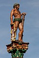
Delémont's old town still has the medieval floor plan with a well-preserved cityscape. Two city gates, the Porte au Loup (today's building from 1775) and the Pruntruter Gate ( Porte de Porrentruy 1756–1759) have been preserved. There are also parts of the former city wall with the Tour des Archives (former Franche Courtine round tower from the 13th century). The squares of the old town are adorned by five monumental figure fountains from the 16th century in the Renaissance style, two of which were created by Hans Michel .
The Catholic Church of Saint-Marcel was built between 1762 and 1767 and has a mixture of style elements from Baroque and Classicism . Other baroque monuments from the time of the prince-bishops are the Hôtel de Ville (town house, built 1742–1745) with richly decorated stucco ceilings in the various halls, the Châtellenie (former bailiwick, rebuilt in 1717 and today a courthouse) and the episcopal palace (1716–1721 ). The late Gothic Saint-Michel chapel dates from the 17th century.
West of the city on the southern slope of the Les Rangiers chain is Domont Castle, a late Gothic complex with a stair tower that was built in 1560 and is now used as a restaurant. The ruins of the early medieval Vorbourg have been preserved on the ridge on the western flank of the Birsklus valley. Next to it is the Chapelle Notre-Dame du Vorbourg , the former house chapel of the lower castle, consecrated in 1049 and later renovated several times; the main altar with the Madonna from the 16th century is the destination of pilgrimages to the Virgin Mary.
The former Capuchin chapel Chapelle de Montcroix northeast of the old town was built in 1950 in the style of Le Raincy near Paris (1922–1923) by the Jura architect Jeanne Bueche and is an exposed concrete church with concrete glass windows; the mural in the choir is by Albert Schnyder .
Delsberg is the recipient of the Wakker Prize 2006. The Swiss Homeland Security honored the city with this “for the revaluation of the public space in the center through renovations and the introduction of a 30 km / h zone”.
Personalities
- Louis Vautrey (1829–1886), clergyman in Delsberg and historian
- Henri L. Le Roy (1926–2015), biometrician and population geneticist at the Swiss Federal Institute of Technology in Zurich
photos

Saint-Michel castle and church

Porte au Loup

Hotel de Parlement

Hotel de Ville (town hall)
Fontaine du Sauvage (Fountain of the Wild)

reformed Church

Porte de Porrentruy (Pruntruter Gate)
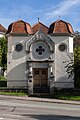
synagogue


Town twinning
Delsberg maintains a partnership with the city of Belfort in Franche-Comté, France .
Web links
|
Further content in the sister projects of Wikipedia:
|
||
|
|
Commons | - multimedia content |
|
|
Wiktionary | - Dictionary entries |
|
|
Wikisource | - Sources and full texts |
- Official website of the city of Delémont
- François Kohler: Delsberg (municipality). In: Historical Lexicon of Switzerland .
Individual evidence
- ↑ Permanent and non-permanent resident population by year, canton, district, municipality, population type and gender (permanent resident population). In: bfs. admin.ch . Federal Statistical Office (FSO), August 31, 2019, accessed on December 22, 2019 .
- ↑ Climate table. In: meteoschweiz.admin.ch. meteoschweiz, accessed on May 29, 2018 .
- ↑ Lexicon of Swiss Community Names , ed. from the Center de Dialectologie at the University of Neuchâtel under the direction of Andres Kristol, Frauenfeld 2005, p. 291.
- ↑ m-ici.ch: Mémoires d'Ici , accessed on February 19, 2011
- ↑ flickr.com: Montcroix Delémont - a set on Flickr , accessed February 19, 2011
AG : Aarau | AR : Herisau | AI : Appenzell | BL : Liestal | BS : Basel | BE : Bern | FR : Freiburg | GE : Geneva | GL : Glarus | GR : Chur | JU : Delémont | LU : Lucerne | NE : Neuchâtel | NW : Stans | OW : Sarnen | SH : Schaffhausen | SZ : Schwyz | SO : Solothurn | SG : St. Gallen | TI : Bellinzona | TG : Frauenfeld | UR : Altdorf | VD : Lausanne | VS : manners | ZG : Zug | ZH : Zurich
Boécourt | Bourrignon | Châtillon | Courchapoix | Courrendlin | Courroux | Courtételle | Delémont | Develier | Ederswiler | Haute-Sorne | Mervelier | Mettembert | Movelier | Pleigne | Rossemaison | Saulcy | Soyhières | Val Terbi
Former municipalities: Bassecourt | Corban | Courfaivre | Glovelier | Montsevelier | Rebeuvelier | Soulce | Undervelier | Vellerat | Vermes | Vicques
Canton of Jura | Districts of the Canton of Jura | Municipalities of the Canton of Jura