
Boécourt
| Boécourt | |
|---|---|
 |
|
| State : |
|
| Canton : |
|
| District : | Delémont |
| BFS no. : | 6702 |
| Postal code : | 2856 |
| Coordinates : | 583 125 / 244529 |
| Height : | 516 m above sea level M. |
| Height range : | 488–951 m above sea level M. |
| Area : | 12.35 km² |
| Residents: | 914 (December 31, 2018) |
| Population density : | 74 inhabitants per km² |
| Website: | www.boecourt.ch |
| Location of the municipality | |
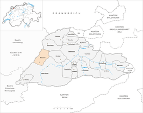  |
|
Boécourt is a municipality in the Delémont district in the canton of Jura in Switzerland . The former German name Biestingen is no longer used today.
geography

Boécourt is 516 m above sea level. M. , ten kilometers west of the canton capital Delémont (straight line). The community extends on the lower southeast slope of the Jura range of Mont Russelin, which separates the Doubstal from the Delsberg basin .
The area of the 12.3 km² municipal area comprises the north-western part of the agriculturally intensively used plain of the Delsberg basin. In the west it extends to the ridge of the Mont Russelin chain, which forms the watershed between the catchment areas of the Rhone (to the Mediterranean Sea ) and the Rhine (to the North Sea ). On the lower southeast slope of this chain there are extensive meadows and pastures, the upper part is covered with forest. The highest point in the municipality is the mountain L'Ordon at 951 m above sea level. M. In the north of the municipal area extends to the slopes of Les Rangiers chain up almost to the summit of Les Rangiers . The eastern part lies in the area of the Rouge-Eau brook and includes the wooded height of Tramont ( 620 m above sea level ). The entire municipality is drained to the Sorne . In 1997, 9% of the municipal area was settled, 42% forest and woodland, 48% agriculture and just under 1% was unproductive land.
Boécourt includes the hamlets of Séprais ( 605 m above sea level ) on a terrace east of the Mont-Russelin chain and Montavon ( 627 m above sea level ) on a promontory on the southern slope of Les Rangiers, the Les Lavoirs farm estate and several individual farms . Neighboring municipalities of Boécourt are Haute-Sorne , Develier , Bourrignon , Clos du Doubs and La Baroche .
population
With 914 inhabitants (as of December 31, 2018), Boécourt is one of the medium-sized communities in the canton of Jura. 91.4% of the residents are French-speaking, 3.9% German-speaking and 2.0% Italian-speaking (as of 2000). The population of Boécourt was 655 in 1850 and 599 in 1900. A slightly increasing trend was noted in the second half of the 20th century.
economy
In the second half of the 20th century, watchmaking developed in Boécourt , specializing in cases and glasses. Since the crisis in the watch industry in 1975, the construction industry has also settled in the community. Agriculture is also of some importance in Séprais and Montavon . However, many workers are commuters and work mainly in the Delémont region.
traffic
The community has good transport links. With the Glovelier exit, it has a connection to the section of the A16 motorway from Delémont to Porrentruy , which was opened in 1998 and which is to be connected to both the Swiss national road network and the French motorway network by 2015. Glovelier train station on the Delémont - Porrentruy railway line is around 2 km from the village center. Bus routes connect Boécourt and its hamlets with the Bassecourt and Glovelier train stations .
history
Boécourt is first mentioned in 1141 as Boescort in a bull from Pope Innocent II , in which the affiliation of the parish Boécourt to the Bellelay monastery was confirmed. The community area was settled much earlier, which was proven by finds of pottery from the late Bronze Age near Les Montoyes. A Roman estate was located in this area from the 1st to the 3rd century AD . An iron mine with smelting furnaces was in operation near Montavon from the High Middle Ages to the 19th century .
As one of the 13 free villages of the Delsberg rule, Boécourt came to the Principality of Basel in 1271 . From 1793 to 1815 it belonged to France and was initially part of the Département du Mont-Terrible , from 1800 connected to the Département Haut-Rhin . By decision of the Congress of Vienna , the place came to the canton of Bern in 1815 and on January 1, 1979 to the newly founded canton of Jura.
The first Swiss military victim of the Second World War, Lieutenant Rudolf Rickenbacher , was killed near Boécourt on June 4, 1940 after an aerial battle with the German Air Force.
Attractions
The Catholic parish church of Saint-Sébastien was rebuilt from 1766. The Saint-Martin chapel is in Montavon. The Balade de Séprais is a sculpture path near the hamlet of Séprais. Modern works of art by artists from Switzerland and abroad can be viewed here.
photos

Boécourt Church

Church window
Parish hall
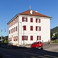
Bürgergemeindehaus
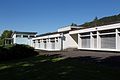
Primary school building
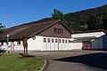
Festival hall

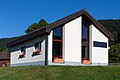
Notre Dame des Deuttes
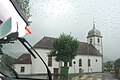
Parish Church of Saint-Sébastien


Personalities
- Eugène Lachat (1819–1886), Bishop of Basel, born in the hamlet of Montavon
Web links
- Official website of the municipality of Boécourt
- Balade de Séprais
- François Kohler: Boécourt. In: Historical Lexicon of Switzerland .
Individual evidence
- ↑ Permanent and non-permanent resident population by year, canton, district, municipality, population type and gender (permanent resident population). In: bfs. admin.ch . Federal Statistical Office (FSO), August 31, 2019, accessed on December 22, 2019 .
Boécourt | Bourrignon | Châtillon | Courchapoix | Courrendlin | Courroux | Courtételle | Delémont | Develier | Ederswiler | Haute-Sorne | Mervelier | Mettembert | Movelier | Pleigne | Rossemaison | Saulcy | Soyhières | Val Terbi
Former municipalities: Bassecourt | Corban | Courfaivre | Glovelier | Montsevelier | Rebeuvelier | Soulce | Undervelier | Vellerat | Vermes | Vicques
Canton of Jura | Districts of the Canton of Jura | Municipalities of the Canton of Jura