
Courchapoix
| Courchapoix | |
|---|---|
 |
|
| State : |
|
| Canton : |
|
| District : | Delémont |
| BFS no. : | 6706 |
| Postal code : | 2825 |
| Coordinates : | 601 385 / 244350 |
| Height : | 496 m above sea level M. |
| Height range : | 471–937 m above sea level M. |
| Area : | 6.39 km² |
| Residents: | 426 (December 31, 2018) |
| Population density : | 67 inhabitants per km² |
| Website: | www.courchapoix.ch |
 The village seen from the church |
|
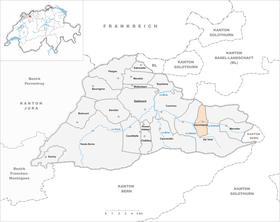
| Location of the municipality | |
  |
|
Courchapoix is a municipality in the Delémont district in the canton of Jura in Switzerland . The former German name Gebsdorf is no longer used today.
geography

Courchapoix is 496 m above sea level. M. , 9 km east of the canton capital Delémont (linear distance). The village extends along the Scheltenbach (French La Scheulte ) in the wide hollow of the Val Terbi , the easternmost part of the Delsberg basin .
The area of the 6.4 km² municipal area comprises a section in the east of the agriculturally intensively used depression of the Delsberg basin. In the municipality, the Ruisseau de Montsevelier stream flows into the Scheltenbach, which flows through a wide valley to the west to the Birs . In the north, the community area extends over the summit of Le Bambois to the Jura ridge of the Fringelikette. The highest point of Courchapoix is 940 m above sea level. M. on this densely wooded ridge . To the south, the municipality extends to the level of Plain Fayen ( 759 m above sea level ), which forms a fold on the edge of the Mont Raimeux chain . In this fold the Gabiare has created a typical Jurassic gorge , the Tiergarten Gorge, through erosion . The eastern slope of this gorge also belongs to Courchapoix. In 1997, 3% of the municipal area was accounted for by settlements, 45% by forests and woodlands and 52% by agriculture.
Courchapoix has several individual farms. The neighboring communities of Courchapoix are Vicques , Vermes and Val Terbi in the canton of Jura and Bärschwil in the canton of Solothurn .
population
With 426 inhabitants (as of December 31, 2018) Courchapoix is one of the smaller communities in the canton of Jura. 98.5% of the residents are French-speaking, 1.3% German-speaking and 0.2% Italian-speaking (as of 2000). The population of Courchapoix was 271 in 1850 and 260 in 1900. A clearly increasing trend has been recorded since the middle of the 20th century.
economy
The agriculture has in the community is still a high priority. However, the village also developed into a residential village in the second half of the 20th century. Many workers (around 55%) are therefore commuters and work mainly in the Delémont region.
traffic
Courchapoix is located on the cantonal road from Delémont over the Schelten Pass to Mümliswil . It is connected to the train station in Delémont by a bus line that runs from the canton capital to Montsevelier .
history
Compared to the other municipalities in the Delémont district, Courchapoix appears relatively late in the documents. In 1453 the place is mentioned for the first time as Curchappoix . Finds of graves from the 10th century indicate a much earlier settlement. The village of Courchapoix belonged to the Moutier-Grandval provost and retained the Catholic faith even after the Reformation . From 1797 to 1815 it belonged to France and was initially part of the Mont-Terrible department , but from 1800 it was linked to the Haut-Rhin department . By decision of the Congress of Vienna , the place came to the canton of Bern to the district of Moutier in 1815 . The residents of Courchapoix voted in Juraplebisziten always for the creation of the Canton of Jura . As a border municipality in the district of Moutier, Courchapoix decided in the referendum on September 7, 1975 for the canton of Jura, moved to the Delémont district in 1976 and came with this on January 1, 1979 to the newly founded canton of Jura.
Attractions
On the slope south of the town center stands the parish church of Saint-Imier, which was built in the 19th century on the foundations of an earlier Romanesque church. Courchapoix belonged to the parish of Vicques until 1781 , after which it formed its own parish before it became dependent on the parish of Corban from 1874 to 1935 . The village has preserved some beautiful old farmhouses from the 18th and 19th centuries.
photos

Saint-Imier Catholic Church in Courchapoix

Interior of the church
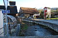
Scheltenbach in Courchapoix

Route Principale

Municipal House and Vis-à-Vis

Saint Imier Church

Primary school building


Web links
- Information about Courchapoix on the Juranet
- François Kohler: Courchapoix. In: Historical Lexicon of Switzerland .
Individual evidence
- ↑ Permanent and non-permanent resident population by year, canton, district, municipality, population type and gender (permanent resident population). In: bfs. admin.ch . Federal Statistical Office (FSO), August 31, 2019, accessed on December 22, 2019 .
Boécourt | Bourrignon | Châtillon | Courchapoix | Courrendlin | Courroux | Courtételle | Delémont | Develier | Ederswiler | Haute-Sorne | Mervelier | Mettembert | Movelier | Pleigne | Rossemaison | Saulcy | Soyhières | Val Terbi
Former municipalities: Bassecourt | Corban | Courfaivre | Glovelier | Montsevelier | Rebeuvelier | Soulce | Undervelier | Vellerat | Vermes | Vicques
Canton of Jura | Districts of the Canton of Jura | Municipalities of the Canton of Jura