
Courroux
| Courroux | |
|---|---|
 |
|
| State : |
|
| Canton : |
|
| District : | Delémont |
| BFS no. : | 6709 |
| Postal code : | 2822 |
| Coordinates : | 595 090 / 245896 |
| Height : | 418 m above sea level M. |
| Height range : | 389–900 m above sea level M. |
| Area : | 19.74 km² |
| Residents: | 3314 (December 31, 2018) |
| Population density : | 168 inhabitants per km² |
| Website: | www.courroux.ch |
 Saint-Nicolas church |
|
| Location of the municipality | |
  |
|
Courroux is a municipality in the Delémont district in the canton of Jura in Switzerland . The former German name Lüttelsdorf is rarely used today.
geography

Courroux lies at 418 m above sea level. M. , 2 km east of the canton capital Delémont . The clustered village extends on the plain east of the Birs in the central part of the Delsberg basin , a wide depression in the Jura .
The area of the 19.7 km² large municipal area comprises a section in the central part of the intensely agricultural plain of the Delsberg basin. The Scheltenbach ( La Scheulte in French ) flows into the Birs near Courroux . In the south, the municipality extends in a narrow strip to the foothills of the Montchemin and Rosé hills , which belong to a fold in the edge of the Mont-Raimeux chain . In the north, the area includes the Jura ridge of the Bambois mountain , the western part of the Fringelikette (in the municipality up to 899 m above sea level ). The steep, wooded southern slope of this ridge is called Côte sur le Bambois . On the ridge of the Bambois is the 837 m high Roc de Courroux , a rocky pulpit with a beautiful view to the north into the middle Birstal and as far as Alsace . The western and northern delimitation of the municipality of Courroux is formed by the Birs, which with a typical clus breaks through the Jura chain bordering the Delsberg basin to the north. In 1997, 7% of the municipal area was accounted for by settlements, 39% for forests and woodlands and 54% for agriculture.
Courroux includes the town of Courcelon ( 426 m above sea level ), which connects to Courroux to the east, the Bellerive farm estate in the Birs Gorge north of Delémont and numerous individual farms. Neighboring communities of Courroux are Vicques , Courrendlin , Delémont and Soyhières in the canton of Jura and Liesberg in the canton of Basel-Landschaft and Bärschwil in the canton of Solothurn .
population
| Population development | |
|---|---|
| year | Residents |
| 1850 | 1173 |
| 1900 | 1333 |
| 1910 | 1455 |
| 1930 | 1575 |
| 1950 | 1626 |
| 1960 | 1667 |
| 1970 | 1788 |
| 1980 | 2158 |
| 1990 | 2437 |
| 2000 | 2733 |
With 3,314 inhabitants (as of December 31, 2018) Courroux is the fourth largest municipality in the canton of Jura. 91.7% of the residents are French-speaking, 3.5% German-speaking and 1.5% Italian-speaking (as of 2000). The population of Courroux increased slowly but steadily until 1970. In the last few decades, however, a significant increase in population has been registered in the wake of the nearby Delémont.
economy
For a long time, Courroux was an agricultural village. It still has large areas on the level of the Delsberg Basin and on the slightly sloping and optimally south-facing lower slope of the Fringelikette, where arable farming is carried out. From around the middle of the 18th century to the middle of the 19th century, iron mining was an important source of income. Today the village has developed into a residential community, and many people work abroad, especially in Delémont.
traffic
The community has good transport links. It is located near Delémont on the road over the Schelten Pass to Mümliswil . After the opening of the Delémont bypass in 2005, there is a close connection to the A16 motorway , which is to be connected to both the Swiss national road network and the French motorway network by 2015. The Delémont - Montsevelier bus line guarantees the connection of Courroux and Courcelon to public transport.
history
The Courroux area can look back on a long tradition of settlement. In the first half of the 20th century, pottery from the late Bronze Age from a settlement was found on the Roc de Courroux . The place was built between 1100 and 800 BC. Used. Other finds can be dated to the Iron Age. In the area of today's village of Courroux, the remains of a Gallo-Roman villa and around 150 graves were found that were dug in the 1st to 3rd centuries AD and contained important grave goods (vessels, coins, statuettes, tools).
Courroux was first mentioned in 1146 under the German name Lütoltesdorf , and in 1148 the French name Corolt also appeared . As one of the 13 free villages of the Delsberg lordship, Courroux came to the Principality of Basel in 1271 . From 1793 to 1815 it belonged to France and was initially part of the Département du Mont-Terrible , from 1800 connected to the Département Haut-Rhin . By decision of the Congress of Vienna , the place came to the canton of Bern in 1815 and on January 1, 1979 to the newly founded canton of Jura. The hamlet of Riedes-Dessus an der Birs, which used to belong to Courroux, was transferred to the municipality of Soyhières in 1856 .
The municipalities of Val Terbi (these are Corban , Courchapoix , Courroux, Mervelier , Montsevelier , Vermes and Vicques ) are currently planning a merger, which should take place at the end of 2012.
Attractions
The Saint-Nicolas church was built in the neo-Gothic style in 1871–1873. Next to it is the parish hall with window crosses from the late Gothic period. The center of Courroux has preserved numerous farmhouses from the 18th and 19th centuries.
The castle of Soyhières, which belongs to the municipality of Courroux, stands on a rocky ridge south of Soyhières. It was probably built in the 11th century and was first mentioned in a document in 1271. Together with the Vorbourg Castle opposite, the traffic through the Birs Gorge north of Delémont was controlled from here. In 1499 at the end of the Swabian War, the castle was destroyed and later at least partially rebuilt.
photos

Village center

church

Ecole Enfantine

Primary school building

Village center

Cantonale route

Stade (sports fields)
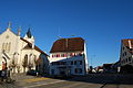
Church and parish hall

Interior of the church
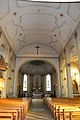
Interior of the church

Inn


Web links
- Official website of the Municipality of Courroux (French)
- François Schifferdecker and François Kohler: Courroux. In: Historical Lexicon of Switzerland .
Individual evidence
- ↑ Permanent and non-permanent resident population by year, canton, district, municipality, population type and gender (permanent resident population). In: bfs. admin.ch . Federal Statistical Office (FSO), August 31, 2019, accessed on December 22, 2019 .
- ↑ Source: Information about the Val Terbi municipal merger
Boécourt | Bourrignon | Châtillon | Courchapoix | Courrendlin | Courroux | Courtételle | Delémont | Develier | Ederswiler | Haute-Sorne | Mervelier | Mettembert | Movelier | Pleigne | Rossemaison | Saulcy | Soyhières | Val Terbi
Former municipalities: Bassecourt | Corban | Courfaivre | Glovelier | Montsevelier | Rebeuvelier | Soulce | Undervelier | Vellerat | Vermes | Vicques
Canton of Jura | Districts of the Canton of Jura | Municipalities of the Canton of Jura