
Saulcy
| Saulcy | |
|---|---|
 |
|
| State : |
|
| Canton : |
|
| District : | Delémont |
| BFS no. : | 6722 |
| Postal code : | 2873 |
| Coordinates : | 578 488 / 239139 |
| Height : | 910 m above sea level M. |
| Height range : | 605-1011 m above sea level M. |
| Area : | 7.86 km² |
| Residents: | 260 (December 31, 2018) |
| Population density : | 33 inhabitants per km² |
| Website: | www.saulcy.ch |
 Saulcy |
|
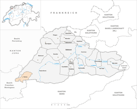
| Location of the municipality | |
  |
|
Saulcy is a municipality in the Delémont district in the canton of Jura in Switzerland .
geography
Saulcy is 910 m above sea level. M. , 16 km west-southwest of the canton capital Delémont (air line). The village extends on a Jura ridge on the northeast edge of the heights of Freiberge (French Franches-Montagnes ).
The area of the 7.9 km² large municipal area includes the wide ridge of the height of Saulcy and extends down the slope in the north, partly to the course of the Tabeillon , a left side stream of the Sorne . In the east the area extends up to the height of the Jolimont , on which with 1010 m above sea level. M. the highest point of the municipality is reached. The southern part of the area is taken up by the deeply carved valleys Combe des Beusses and Combe Montjean . In 1997, 3% of the municipal area was accounted for by settlements, 50% for forests and woodlands and 47% for agriculture.
Saulcy includes the hamlet of La Racine , 913 m above sea level. M. on the ridge east of Saulcy, as well as several individual farms. The neighboring communities of Saulcy are Lajoux , Saint-Brais , Glovelier and Undervelier in the canton of Jura and Rebévelier in the canton of Bern .
population
With 260 inhabitants (as of December 31, 2018), Saulcy is one of the smaller communities in the canton of Jura. 97.0% of the residents are French-speaking and 2.7% German-speaking (as of 2000). The population of Saulcy was 299 in 1850 and 256 in 1900. In the course of the 20th century, the population always fluctuated between 220 and 280 people.
economy
The community is still predominantly agricultural. There are few jobs outside of the agricultural sector in the village. Many employees (around 60%) are therefore commuters and work mainly in the Delémont region.
traffic
Saulcy is off the major roads. The village is connected to public transport by a bus line that runs on the Glovelier - Tramelan route.
history

Saulcy is first mentioned in 1327 as Sacis ; the hamlet of Racine was first mentioned in 1181. The territory of Saulcy was part of the Principality of Basel . The place was badly damaged in the Thirty Years' War . Saulcy belonged to Glovelier until 1793 , after which it became independent. From 1793 to 1815 the place belonged to France and was initially part of the Département du Mont-Terrible , from 1800 connected with the Département Haut-Rhin . By decision of the Congress of Vienna , the place came to the canton of Bern in 1815 and on January 1, 1979 to the newly founded canton of Jura. Saulcy has had its own church since the beginning of the 19th century, making it an independent parish.
photos
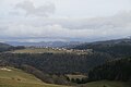
Saulcy

Partial view of Saulcy
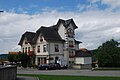
Hotel Bellevue

Church and cemetery

Interior of the church

Church window

Schoolhouse and gym

Parish Secretariat


Web links
- Official website of the municipality of Saulcy
- François Kohler: Saulcy. In: Historical Lexicon of Switzerland .
Individual evidence
- ↑ Permanent and non-permanent resident population by year, canton, district, municipality, population type and gender (permanent resident population). In: bfs. admin.ch . Federal Statistical Office (FSO), August 31, 2019, accessed on December 22, 2019 .
Boécourt | Bourrignon | Châtillon | Courchapoix | Courrendlin | Courroux | Courtételle | Delémont | Develier | Ederswiler | Haute-Sorne | Mervelier | Mettembert | Movelier | Pleigne | Rossemaison | Saulcy | Soyhières | Val Terbi
Former municipalities: Bassecourt | Corban | Courfaivre | Glovelier | Montsevelier | Rebeuvelier | Soulce | Undervelier | Vellerat | Vermes | Vicques
Canton of Jura | Districts of the Canton of Jura | Municipalities of the Canton of Jura