
Montsevelier
| Montsevelier | ||
|---|---|---|
 |
||
| State : |
|
|
| Canton : |
|
|
| District : | Delémont | |
| Municipal municipality : | Val Terbi | |
| Postal code : | 2828 | |
| former BFS no. : | 6717 | |
| Coordinates : | 605267 / 245742 | |
| Height : | 565 m above sea level M. | |
| Area : | 7.75 km² | |
| Residents: | 509 (December 31, 2012) | |
| Population density : | 66 inhabitants per km² | |
| Website: | www.montsevelier.ch | |
| map | ||
|
||


Montsevelier was a municipality in the Delémont district of the canton of Jura in Switzerland . The former German name Mutzwiler is no longer used today. On January 1, 2013, it merged with the municipalities of Vermes and Vicques to form the new municipality of Val Terbi .
geography
Montsevelier is 565 m above sea level. M. , 13 kilometers east of the canton capital Delémont (beeline). The farming village stretches along the Ruisseau de Montsevelier stream in Val Terbi, the easternmost section of the Delsberg basin , a wide depression in the Jura .
The area of the 7.8 km² municipal area comprises a small section of the agriculturally intensively used valley of the Delsberg basin. The municipality is drained by the Montsevelier brook, a right side brook of the Scheltenbach ( La Scheulte in French ), to the west to the Birs . In the north and east, Montsevelier is framed by high Jura ridges. The northern municipal boundary runs on the ridge of the Fringelikette ( L'Aibaiteuse , 921 m above sea level ). To the northeast there is a footpath over the Welschgätterli ( 810 m above sea level ) and to the east on a drivable field path there is a connection with the Lüsseltal . The highest point of the municipality is reached in the southeast on the 1073 m high Grand Mont . In 1997, 4% of the municipal area was accounted for by settlements, 45% by forests and woodlands and 51% by agriculture.
Several individual farms belong to Montsevelier. Neighboring communities of Montsevelier are Mervelier and Corban in the canton of Jura and Bärschwil , Grindel , Erschwil and Beinwil in the canton of Solothurn .
population
With 509 inhabitants (as of December 31, 2012), Montsevelier was one of the smaller communities in the canton of Jura. 96.2% of the residents are French-speaking and 3.2% German-speaking (as of 2000). The population of Montsevelier was 414 in 1850 and 384 in 1900. Population growth has continued over the course of the 20th century. Since 1980 (556 inhabitants) there have only been minor fluctuations.
economy
The community is still dominated by agriculture. In the village, however, there are also jobs in the secondary sector, namely in the areas of machine tool construction, watchmaking and precision engineering. Nevertheless, many employed people (over 50%) are commuters and work mainly in the Delémont region.
traffic
Montsevelier is away from through streets. The municipality is connected to public transport by a bus line that runs from Delémont via Mervelier to Montsevelier.
history
Finds of traces of a Burgundian ceramic workshop suggest that the municipality was settled around the 7th century. The place was first mentioned in 1136 as Muzivilir . A little later the names Munhewilare (1139), Muzwillare (1140), Motzwilre (1242), Muzwilr (1291), Mussevelier (1317) and finally Moncevelier (1462) appear. The place name probably goes back to the homestead of a Musso or Muzzo at the time of the Carolingians .
Montsevelier formed an exclave of the rule of Delémont and was surrounded to the west and south by the territory of the Moutier-Grandval provost. This was neutral as Helvetic sovereign territory and was initially not affected when the French occupied Delsberg in 1792. Therefore Montsevelier could not be taken. As a result, the municipality declared itself an independent République de Montsevelier , which lasted until 1798. In that year Montsevelier was annexed to France . Initially it was part of the Département du Mont-Terrible , in 1800 it was linked to the Département Haut-Rhin . As a result of the decision of the Congress of Vienna in 1815, the place came to the canton of Bern and remained an exclave of the Delémont district. This special administrative status only ended when the neighboring communities of Mervelier and Corban transferred to the Delémont district in 1976 as part of the creation of the canton of Jura. On January 1, 1979, Montsevelier came together with the other municipalities to the newly founded canton of Jura.
The municipalities of Val Terbi (these are Corban , Courchapoix , Courroux , Mervelier , Montsevelier, Vermes and Vicques ) are currently planning a merger, which should take place at the end of 2012.
Attractions
The current village church in the style of eclecticism was built between 1900 and 1901. It stands on the site of an earlier church from the 17th century. Mervelier and Schelten also belonged to the parish of Montsevelier until 1771 . The Saint-Grat chapel is located outside the village on the municipal border with Mervelier.

View of the village
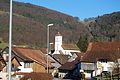
Village center with church

church

graveyard

Primary school building
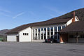
gym
Place du 23 juin

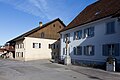
western part of the village


Personalities
- Sarah Marquis (* 1972), travel writer
Web links
- Official website of the municipality of Montsevelier
- François Kohler: Montsevelier. In: Historical Lexicon of Switzerland .
Individual evidence
Boécourt | Bourrignon | Châtillon | Courchapoix | Courrendlin | Courroux | Courtételle | Delémont | Develier | Ederswiler | Haute-Sorne | Mervelier | Mettembert | Movelier | Pleigne | Rossemaison | Saulcy | Soyhières | Val Terbi
Former municipalities: Bassecourt | Corban | Courfaivre | Glovelier | Montsevelier | Rebeuvelier | Soulce | Undervelier | Vellerat | Vermes | Vicques
Canton of Jura | Districts of the Canton of Jura | Municipalities of the Canton of Jura