
Develier
| Develier | |
|---|---|
 |
|
| State : |
|
| Canton : |
|
| District : | Delémont |
| BFS no. : | 6712 |
| Postal code : | 2802 |
| UN / LOCODE : | CH DVR |
| Coordinates : | 589 108 / 245132 |
| Height : | 477 m above sea level M. |
| Height range : | 441–882 m above sea level M. |
| Area : | 12.47 km² |
| Residents: | 1354 (December 31, 2018) |
| Population density : | 109 inhabitants per km² |
| Website: | www.develier.ch |
 Develier |
|
| Location of the municipality | |
  |
|

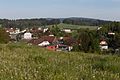
Develier is a municipality in the Delémont district in the canton of Jura in Switzerland . The former German name Dietwiler is no longer used today.
geography

Develier lies at 477 m above sea level. M. , 4 km west of the canton capital Delémont . The former street line village extends in the lowlands of the La Pran brook , in the central part of the Delsberg basin , a wide depression in the Jura .
The area of the community area of 12.4 km² comprises a section in the central part of the intensely agriculturally used plain of the Delsberg basin. In the north, the municipality extends to the ridge of the Jura range from Les Rangiers (on the Develier ground up to 880 m above sea level ). The two brooks La Pran and La Golatte arise on the southern slope of this chain and flow eastwards through the open valley of Develier and drain the municipality of the Sorne , a left tributary of the Birs . The southern boundary of the area is formed by the Chaux hill ( 614 m above sea level ), an isolated elevation in the Delsberg basin. In 1997, 9% of the municipal area was accounted for by settlements, 43% for forests and woodlands and 49% for agriculture.
Develier includes the hamlet Develier-Dessus , 564 m above sea level. M. on the southern slope of the Les Rangiers chain, as well as several individual farms. The neighboring communities of Develier are Bassecourt , Courfaivre , Courtételle , Delémont , Bourrignon and Boécourt .
population
With 1,354 inhabitants (as of December 31, 2018), Develier is one of the medium-sized communities in the canton of Jura. 93.8% of the residents are French-speaking, 2.6% German-speaking and 1.2% Italian-speaking (as of 2000). The population of Develier was 590 in 1850 and 632 in 1900. Since 1950 (647 inhabitants) there has been a significant increase in population combined with a doubling of the number of inhabitants within 50 years.
economy
Develier was a farming village until the middle of the 20th century. Since the end of the 1960s, an industrial and commercial zone has been built on the eastern edge of the village thanks to its proximity to Delémont and good transport links. There are jobs in the building materials and furniture industries as well as in the manufacture of watch cases. Today the community has developed into a residential village and many employed people (around 65%) are commuters.
traffic
The community has good transport links. It is located on the old main road from Delémont over the Les Rangiers pass to Porrentruy and had lively through traffic until the opening of the Delémont - Porrentruy section of the A16 motorway . This motorway bypasses the village on its southern edge and was relocated in an 800 m long opencast mine in the area of the town center for noise protection. Develier is connected to public transport by the bus route from Delémont to Lucelle .
history
There was already a settlement in the municipality during Roman times , and the remains of a Roman villa were found. From the 6th to the 8th centuries, local iron was processed here in several forges.
The place is mentioned for the first time in 1139 as a divilier in a bull by Pope Innocent II . In later times, the names Titewilre (1184) and Tutwilre (1350) appear, from which the German place name was derived. As one of the 13 free villages of the Delsberg rule, Develier came to the duchy of Basel in 1271 . From 1793 to 1815 it belonged to France and was initially part of the Département du Mont-Terrible , from 1800 connected to the Département Haut-Rhin . By decision of the Congress of Vienna , the place came to the canton of Bern in 1815 and on January 1, 1979 to the newly founded canton of Jura.
Attractions
The current parish church of Saint-Imier dates from 1751 and was renovated in 1958. The parish Develier existed since the 13th century, only in the meantime (1874–1907) it became dependent on the parish Courfaivre . The Sainte-Philomène chapel has stood in the hamlet of Develier-Dessus since 1838. North of the village, the Carmelite convent Notre-Dame de la Solitude was built in 1978-80.
photos
Develier
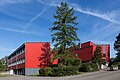
Primary school building

Local government
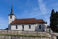
Saint-Imier church

Chapelle de l'Unité


Web links
- Official website of the municipality of Develier
- François Kohler: Develier. In: Historical Lexicon of Switzerland .
Individual evidence
- ↑ Permanent and non-permanent resident population by year, canton, district, municipality, population type and gender (permanent resident population). In: bfs. admin.ch . Federal Statistical Office (FSO), August 31, 2019, accessed on December 22, 2019 .
Boécourt | Bourrignon | Châtillon | Courchapoix | Courrendlin | Courroux | Courtételle | Delémont | Develier | Ederswiler | Haute-Sorne | Mervelier | Mettembert | Movelier | Pleigne | Rossemaison | Saulcy | Soyhières | Val Terbi
Former municipalities: Bassecourt | Corban | Courfaivre | Glovelier | Montsevelier | Rebeuvelier | Soulce | Undervelier | Vellerat | Vermes | Vicques
Canton of Jura | Districts of the Canton of Jura | Municipalities of the Canton of Jura