
Soyhières
| Soyhières | |
|---|---|
 |
|
| State : |
|
| Canton : |
|
| District : | Delémont |
| BFS no. : | 6724 |
| Postal code : | 2805 |
| Coordinates : | 594 988 / 249139 |
| Height : | 402 m above sea level M. |
| Height range : | 383–839 m above sea level M. |
| Area : | 7.50 km² |
| Residents: | 433 (December 31, 2018) |
| Population density : | 58 inhabitants per km² |
| Website: | www.soyhieres.ch |
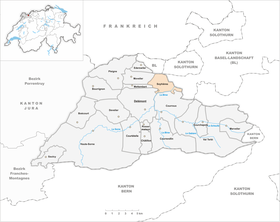
 Soyhières |
|
| Location of the municipality | |
  |
|
Soyhières (French [ swajɛr ], in the local dialect [ a swajir ]) is a political municipality in the district of Delsberg in the Swiss canton of Jura . The German name suckers is hardly known anymore.
geography
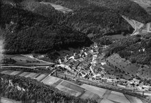
Soyhières is 402 m above sea level. M. , 3.5 km north-northeast of the canton capital Delsberg (linear distance). The village extends on the northern edge of the Birs valley , at the mouth of the Mettembert stream, in the heavily chambered hilly landscape of the northern Jura .
The area of the 7.5 km² large municipal area comprises a section of the folded Jura north of the Delsberg basin . The southern border is usually the Birs. From here the area extends over the lower part of the valley of Mettembert and its side valleys, which break through the Jura chains in gorges and in some cases have formed striking rock peaks. The municipality includes the heights of La Joux ( 817 m above sea level ) and L'Aibet (German Äbi, 747 m above sea level ) and extends in the far north to the Hasenschell, which is 840 m above sea level. M. on the soil of Soyhières forms the highest point in the commune. In the east, Soyhières owns a small portion of the northern slope of the Fringelikette. In 1997, 6% of the municipal area was in settlements, 63% in forests and woodlands, 30% in agriculture and a little more than 1% was unproductive land.
To Soyhières belong the hamlet Riedes-Dessus (German Oberriederwald ), 386 m above sea level. M. in the deep valley of the Birs between the Äbi and the Fringelikette, as well as several individual farms. Neighboring communities of Soyhières are Courroux , Delsberg, Mettembert and Movelier in the canton of Jura and Roggenburg and Liesberg in the canton of Basel-Landschaft .
population
With 433 inhabitants (as of December 31, 2018) Soyhières is one of the smaller communities in the canton of Jura. 77.4% of the residents are French-speaking, 17.2% German-speaking and 2.2% Italian-speaking (as of 2000). The population of Soyhières was 279 in 1850 and 507 in 1900. Several major fluctuations were recorded in the course of the 20th century; the previous high was recorded in 1910 with 592 inhabitants.
economy
The municipality, which used to be dominated by agriculture , has developed into a residential village in recent decades. There are few jobs outside of the agricultural sector in the village. Many employees (more than 50%) are commuters and work mainly in the nearby Delsberg or Laufental and in the Basel region .
traffic
The community has good transport links. It is located on the main road from Basel to Delsberg. On September 25, 1875, the Jura Railway Basel - Delsberg was opened with a station in Soyhières, but this has been shut down since the 1990s and trains pass by. Soyhières is only connected to public transport by bus lines that run from Delémont to the municipalities of the Northern Jura.
history
The village is first mentioned in 1102 as Sougere and 1136 as Sohires . Soyhières belonged to the counts who resided in Soyhières Castle, which stands on a rocky ridge south of the municipality, but belongs to the municipality of Courroux . The counts administered the Sornegau , which came to the counts of the Alsatian Ferrette in the 13th century . In 1271 Soyhières was sold to the Principality of Basel . From 1793 to 1815 the place belonged to France and was initially part of the Département du Mont-Terrible , from 1800 connected with the Département Haut-Rhin . As a result of the decision of the Congress of Vienna , Soyhières came to the canton of Bern in 1815 and to the newly founded canton of Jura on January 1, 1979.
The hamlet of Riedes-Dessus came from Courroux to Soyhières in 1856 , but still forms its own civil parish today.
Attractions
The current parish church was built in 1936–39 on the site of the previous building from 1715. In the crypt is the grave of the village priest Père Jean-Pierre Blanchard, who died in 1824. In the center of the village is the Chappuis house, the former hostel for the White Cross from the middle of the 18th century, which today houses a boarding school for girls. The Notre-Dame de Lourdes chapel stands on a promontory north of the village. Another chapel is located in Riedes-Dessus. In 1994 the fish pond Étang de la Réselle was dammed in a clus north of Soyhières .
photos

church

school

Chapelle ND de Lourdes

Etang de la Réselle
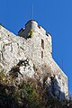
Soyhières Castle (located in the Courroux municipality )


Personalities
- Maria Salesia Chappuis (1793–1875), French-Swiss religious, superior of the Visitation Monasteries in Troyes and Paris, inspired the French Father Louis Brisson to found the Oblates of St. Francis de Sales .
Web links
- Official website of the municipality of Soyhières
- François Kohler: Soyhières. In: Historical Lexicon of Switzerland .
Individual evidence
- ↑ Permanent and non-permanent resident population by year, canton, district, municipality, population type and gender (permanent resident population). In: bfs. admin.ch . Federal Statistical Office (FSO), August 31, 2019, accessed on December 22, 2019 .
- ↑ a b Lexicon of Swiss Community Names , ed. from the Center de Dialectologie at the University of Neuchâtel under the direction of Andres Kristol, Frauenfeld 2005, p. 846.
Boécourt | Bourrignon | Châtillon | Courchapoix | Courrendlin | Courroux | Courtételle | Delémont | Develier | Ederswiler | Haute-Sorne | Mervelier | Mettembert | Movelier | Pleigne | Rossemaison | Saulcy | Soyhières | Val Terbi
Former municipalities: Bassecourt | Corban | Courfaivre | Glovelier | Montsevelier | Rebeuvelier | Soulce | Undervelier | Vellerat | Vermes | Vicques
Canton of Jura | Districts of the Canton of Jura | Municipalities of the Canton of Jura