
Bourrignon
| Bourrignon | |
|---|---|
 |
|
| State : |
|
| Canton : |
|
| District : | Delémont |
| BFS no. : | 6703 |
| Postal code : | 2803 |
| Coordinates : | 585 342 / 249619 |
| Height : | 770 m above sea level M. |
| Height range : | 616–996 m above sea level M. |
| Area : | 13.55 km² |
| Residents: | 262 (December 31, 2018) |
| Population density : | 19 inhabitants per km² |
| Website: | www.bourrignon.ch |
 Bourrignon |
|
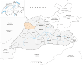
| Location of the municipality | |
  |
|
Bourrignon is a municipality in the Delémont district in the canton of Jura in Switzerland . The former German name Bürkis is no longer used today.
geography

Bourrignon is 770 m above sea level. M. , 8 km west-northwest of the canton capital Delémont (linear distance). The street line village is located on a north-facing protrusion of the Jura chain from Les Rangiers above the valley of the Lucelle (German Lützel ).
The area of the 13.6 km² municipal area includes the source area of the Lucelle in the Folded Jura . In the south, part of the high ridge of the Les Rangiers chain belongs to Bourrignon. The highest point in the municipality is located on the Les Ordons mountain ( 995 m above sea level ), and here is a regional relay station. In the south-east lies the Burgisberg plateau (up to 893 m above sea level ). The northern part is taken by the valley of the Lucelle with its side streams, with the steep slope of the Côte de Mai and part of the Truchet plateau ( 808 m above sea level ) still belonging to Bourrignon. In the far west, the municipality extends to the Grande Roche ( 848 m above sea level ), a rock on the range of hills that form the eastern boundary of the Ajoie . In 1997, 3% of the municipal area was accounted for by settlements, 32% for forests and woodlands, and 65% for agriculture.
Bourrignon includes the La Burgisberg farm estate ( 832 m above sea level ) and several individual farms. Neighboring communities of Bourrignon are La Baroche , Pleigne , Delémont , Develier and Boécourt .
population
With 262 inhabitants (as of December 31, 2018) Bourrignon is one of the smaller communities in the canton of Jura. 93.7% of the residents are French-speaking and 4.9% German-speaking (as of 2000). The population of Bourrignon was 359 inhabitants in 1850 and 330 inhabitants in 1900. After that, a further 33% decrease to 221 people was registered due to strong emigration by 1980. Since then, the population has increased significantly again.
economy
The community is still strongly characterized by agriculture . There are few jobs outside of the agricultural sector in the village. Many employees (around 50%) are therefore commuters and work mainly in the Delémont region.
traffic
Bourrignon is located on a regional thoroughfare that connects Delémont with Lucelle and the French Ferrette in Alsace . The village is connected to public transport by the Delémont - Lucelle bus line .
history
Bourrignon was first mentioned in 1136 as Borognun . The name Burgis is known from 1295 , which led to the former German name Bürkis . The name probably goes back to a Roman court that was later settled by the Burgundians . In the 11th century, Bourrignon belonged to the Cistercian Abbey of Lützel . As one of the 13 free villages of the Delsberg rule, Bourrignon came to the duchy of Basel in 1271 . From 1793 to 1815 it belonged to France and was initially part of the Département du Mont-Terrible , from 1800 connected to the Département Haut-Rhin . By decision of the Congress of Vienna , the place came to the canton of Bern in 1815 and on January 1, 1979 to the newly founded canton of Jura.
Attractions
Bourrignon was a parish as early as 1181. The current baroque church of Saint-Sébastien was built between 1747 and 1749, the furnishings (altars, statues and paintings) also date from this period; the front tower was built in 1774. During a restoration of the church from 1974-77, a coin treasure from the Baroque period was discovered.
Web links
- Official website of the municipality of Bourrignon
- François Kohler: Bourrignon. In: Historical Lexicon of Switzerland .
Individual evidence
- ↑ Permanent and non-permanent resident population by year, canton, district, municipality, population type and gender (permanent resident population). In: bfs. admin.ch . Federal Statistical Office (FSO), August 31, 2019, accessed on December 22, 2019 .
Boécourt | Bourrignon | Châtillon | Courchapoix | Courrendlin | Courroux | Courtételle | Delémont | Develier | Ederswiler | Haute-Sorne | Mervelier | Mettembert | Movelier | Pleigne | Rossemaison | Saulcy | Soyhières | Val Terbi
Former municipalities: Bassecourt | Corban | Courfaivre | Glovelier | Montsevelier | Rebeuvelier | Soulce | Undervelier | Vellerat | Vermes | Vicques
Canton of Jura | Districts of the Canton of Jura | Municipalities of the Canton of Jura