
Pleigne
| Pleigne | |
|---|---|
 |
|
| State : |
|
| Canton : |
|
| District : | Delémont |
| BFS no. : | 6719 |
| Postal code : | 2807 |
| Coordinates : | 589 014 / 250 846 |
| Height : | 809 m above sea level M. |
| Height range : | 500–854 m above sea level M. |
| Area : | 17.84 km² |
| Residents: | 356 (December 31, 2018) |
| Population density : | 20 inhabitants per km² |
| Website: | www.pleigne.ch |
 Former restaurant, farm with farm buildings, Lucelle JU |
|
| Location of the municipality | |
  |
|
Pleigne is a municipality in the Delémont district in the canton of Jura in Switzerland . The former German name Pleen is no longer used today.
geography
Pleigne is 809 m above sea level. M. , 6 km northwest of the canton capital Delémont (air line). The former street row village is located on a high plateau in the hilly landscape of the northern Jura , near the border with France .
The area of the 17.8 km² municipal area includes the high plateau of Pleigne (up to 842 m above sea level ) , which is largely covered by meadows . This is bordered in the south by the valley of the Côte de Mai , in the west and north by the valley of the Lucelle (German Lützel ) and in the east by the Bavelier valley. In the south, the municipality extends over the plateau Sur la Croix (at 850 m above sea level , the highest point of the municipality is located here) into the upper part of the Mettembert valley and up to the northern slopes of the Les Rangiers chain. In the far west the area includes the basin of Lucelle and the eastern slope of Les Aidjolats (up to 740 m above sea level ). To the east, the community area extends over the Lob ( 805 m above sea level ) and the heights from Löwenburg to the Bösenbach . The entire northern border is formed by the course of the Lucelle, which at the same time represents the border with France and drains almost the entire municipality. In 1997, 3% of the municipal area was accounted for by settlements, 50% for forests and woodlands and 47% for agriculture.
Pleigne includes the hamlets Lucelle ( 604 m above sea level ) on a dammed lake of the Lucelle, Löwenburg ( 585 m above sea level ) on a terrace above the Lützeltal and the houses of Moulin-Neuf (German Neumühle ) as well as numerous individual farms. Neighboring communities of Pleigne are La Baroche , Bourrignon , Mettembert , Movelier and Ederswiler in the canton of Jura, Roggenburg in the canton of Basel-Landschaft and Lucelle and Kiffis in France.
population
With 356 inhabitants (as of December 31, 2018), Pleigne is one of the smaller communities in the canton of Jura. Of the residents, 85.1% are French-speaking and 14.2% German-speaking (as of 2000). The population of Pleigne was 443 in 1850 and 418 in 1900. In the course of the 20th century, the population always fluctuated between 340 and 440 people.
economy
The community is still predominantly agricultural. There are few jobs outside of the agricultural sector in the village. Many employed persons (more than 50%) are therefore commuters and work mainly in the Delémont region.
traffic
Pleigne is very remote and only connected to the neighboring towns by small municipal roads. The village is connected to public transport by the bus route that runs from Delémont via Mettembert to Pleigne, as is the hamlet of Lucelle with the Charmoille-Lucelle-Delémont bus route.
history


Pleigne is first mentioned in 1179 in a document from Pope Alexander III. as Plenna . This name goes back to the Latin planeolum ( small plateau ). Pleigne was one of the 13 free villages in the Delsberg domain. The Lützel monastery had basic rights in large parts of today's municipality. The place belonged to the Counts of Thierstein as a fief between 1389 and 1454 , after which it came to the Principality of Basel . From 1793 to 1815 Pleigne belonged to France and was initially part of the Département du Mont-Terrible , from 1800 connected to the Département Haut-Rhin . By decision of the Congress of Vienna , the place came to the canton of Bern in 1815 and on January 1, 1979 to the newly founded canton of Jura.
Attractions
The Pleigne church was built in 1787 in the Baroque style on the site of an earlier church. Its bell tower has a Byzantine dome. The church windows designed by André Brêchet in 1953 are noteworthy and are among the first of their kind in the canton of Jura. Next to the church are the rectory from 1825 and the former schoolhouse from 1845. The mill in the Bavelier valley dates from 1629 and was renovated in 1710. There is also a historic inn in the hamlet of Moulin-Neuf.
To the north of the village of Pleigne is the Pleigne panorama tower on a small hill . In the hamlet of Löwenburg there is a ruined castle and a former priory of the Lützel monastery .
photos

Village center

Schoolhouse, gym

Chapel Niklaus vdFlüh
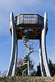
Observation tower

Hotel Moulin Neuf on the Lüssel

Löwenburg


Web links
- Official website of the municipality of Pleigne
- François Kohler: Pleigne. In: Historical Lexicon of Switzerland .
Individual evidence
- ↑ Permanent and non-permanent resident population by year, canton, district, municipality, population type and gender (permanent resident population). In: bfs. admin.ch . Federal Statistical Office (FSO), August 31, 2019, accessed on December 22, 2019 .
Boécourt | Bourrignon | Châtillon | Courchapoix | Courrendlin | Courroux | Courtételle | Delémont | Develier | Ederswiler | Haute-Sorne | Mervelier | Mettembert | Movelier | Pleigne | Rossemaison | Saulcy | Soyhières | Val Terbi
Former municipalities: Bassecourt | Corban | Courfaivre | Glovelier | Montsevelier | Rebeuvelier | Soulce | Undervelier | Vellerat | Vermes | Vicques
Canton of Jura | Districts of the Canton of Jura | Municipalities of the Canton of Jura