
Courrendlin
| Courrendlin | |
|---|---|
 |
|
| State : |
|
| Canton : |
|
| District : | Delémont |
| BFS no. : | 6708 |
| Postal code : | 2830 Courrendlin 2830 Vellerat 2832 Rebeuvelier |
| Coordinates : | 595 087 / 243117 |
| Height : | 436 m above sea level M. |
| Height range : | 415–1293 m above sea level M. |
| Area : | 21.55 km² |
| Residents: | 3064 (December 31, 2018) |
| Population density : | 142 inhabitants per km² |
| Website: | www.courrendlin.ch |
 The "Tour de l'Horloge" in Courrendlin |
|
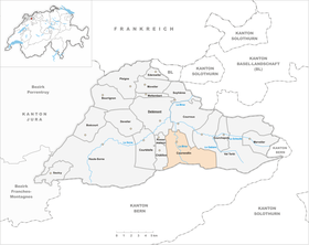
| Location of the municipality | |
  |
|
Courrendlin is a municipality in the Delémont district in the canton of Jura in Switzerland . The former German name Rennendorf is no longer used today.
On January 1, 2019, Courrendlin merged with Rebeuvelier and Vellerat to form the municipality of Courrendlin.
geography

Courrendlin is 436 m above sea level. M. , 4 km southeast of the canton capital Delémont (linear distance). The Haufendorf extends on both sides of Birs , at the output from the Klus of Choindez the south of the Delémont basin , a broad depression in the Faltenjura . The area of the 11.1 km² large municipal area comprises a section in the central part of the agriculturally intensively used plain of the Delsberg basin. The entire northern part of the municipality is occupied by the Plaine de Bellevie . In the west the area extends to the Montchaibeux ( 627 m above sea level ), an isolated forest hill in the Delsberg basin. To the south, the municipal area includes the Choindez gorge, a typical Jura gorge carved out by the Birs with striking rock faces, which is part of the Gorges de Moutier system . The gorge is flanked in the east by the Rochers du Midi ( 870 m above sea level ) on Montchemin , in the west by a steep, densely forested mountain of the Forêt de la Cendre (up to 1000 m above sea level ). This mountain belongs to the fold of the Jura range of Le Mont . In the very south, the municipality extends to the vertically rising limestone rib of the Roche Saint-Jean . In 1997, 13% of the municipal area was in settlements, 41% in forests and woodland, 45% in agriculture and a little more than 1% was unproductive land.
Courrendlin includes the Choindez industrial estate ( 460 m above sea level ) in the Choindez Gorge and several individual farms. The neighboring communities of Courrendlin are Vellerat , Châtillon , Rossemaison , Delémont , Courroux and Rebeuvelier in the canton of Jura and Roches in the canton of Bern .
population
| year | Residents |
|---|---|
| 1850 | 731 |
| 1900 | 1908 |
| 1910 | 2098 |
| 1930 | 1921 |
| 1950 | 2218 |
| 1960 | 2418 |
| 1970 | 2656 |
| 1980 | 2435 |
| 1990 | 2411 |
| 2000 | 2435 |
With 3,064 inhabitants (as of December 31, 2018) Courrendlin is one of the large municipalities in the canton of Jura. 88.4% of the residents are French-speaking, 5.2% German-speaking and 1.8% Italian-speaking (as of 2000). Courrendlin's population nearly tripled in the second half of the 19th century. After a preliminary high around 1970, a decline of almost 10% was recorded during the economic crisis of the 1970s. Since then there have been only minor fluctuations in population.
economy
Courrendlin developed from a farming village to an industrial community in the mid-19th century. An important employer in the village is the Von Roll ironworks , which was founded in Choindez in 1843. There are further jobs in the areas of mechanical engineering and plastics production. To the north of the village in the plain there is a large gravel mining area, and at the end of the Choindez gorge, Jurassic limestone is being mined in an important quarry .
traffic
The community has good transport links. It is located on the busy thoroughfare from Delémont to Moutier . The planned motorway or A16 motorway, which should be connected to both the Swiss national road network and the French motorway network by 2015, will bypass the village and the Choindez gorge to the east in a 3 km long tunnel. On December 16, 1876, the Delémont – Moutier railway was opened with a station in Courrendlin, which is now closed.
history
The place is first mentioned in 866 as Rendelana Corte . Already in the 9th century it belonged to the property of the Provost Moutier-Grandval . The current name Courrendlin appeared for the first time in 1179, but in the following time the names Corrandlain or Rellendorf (1184), the German name Rennendorf (1285), Corrandelinim (1438) and Curraldin , Correndlin (1461) also appeared.
Courrendlin retained the Catholic faith even after the Reformation . From 1797 to 1815 it belonged to France and was initially part of the Mont-Terrible department , but from 1800 it was linked to the Haut-Rhin department . By decision of the Congress of Vienna , the place came to the canton of Bern to the district of Moutier in 1815 . The residents of Courrendlin voted in Juraplebisziten always for the creation of the Canton of Jura . As a border community in the district of Moutier, Courrendlin decided in the referendum on September 7, 1975 for the canton of Jura, moved to the Delémont district in 1976 and came with this on January 1, 1979 to the newly founded canton of Jura.
Attractions
- The oldest church in the Courrendlin area is the Saint-Barthélemy chapel, which stands outside the village. It dates from the 9th century and was rebuilt several times and renovated in 1977.
- The parish church of Saint-Germain-et-Randoald (named after two martyrs of the region) was built between 1755 and 1758. It contains one of the most beautiful baroque interiors in the canton of Jura. In 1923 the church tower was badly damaged by a hurricane. The parish of Courrendlin also included Rossemaison, Châtillon and Vellerat.
- A “crucified person” from the Church of Courrendlin, created by Martin Hoffmann around 1525, is now in the Basel Historical Museum .
- In the center of the village is the Tour de l'Horloge , a late Gothic prison and archive tower with stepped gables , which was built in 1697.
photos

Parish church

reformed Church

Gym and secondary school house

Motorway bridge in the Choindez district

Village center
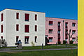
Housing estate on Rue en Solé

Historical aerial photo of the steelworks "Von Roll" (Choindez) by Walter Mittelholzer between 1918 and 1937


Web links
- François Kohler: Courrendlin. In: Historical Lexicon of Switzerland .
- Courrendlin municipality website
Individual evidence
- ↑ Permanent and non-permanent resident population by year, canton, district, municipality, population type and gender (permanent resident population). In: bfs. admin.ch . Federal Statistical Office (FSO), August 31, 2019, accessed on December 22, 2019 .
- ↑ Hoffmann's «Crucified» by Courrendlin ( Memento of the original from January 4, 2016 in the Internet Archive ) Info: The archive link was inserted automatically and has not yet been checked. Please check the original and archive link according to the instructions and then remove this notice. on the website of the Historisches Museum Basel , accessed on January 4, 2016.
Boécourt | Bourrignon | Châtillon | Courchapoix | Courrendlin | Courroux | Courtételle | Delémont | Develier | Ederswiler | Haute-Sorne | Mervelier | Mettembert | Movelier | Pleigne | Rossemaison | Saulcy | Soyhières | Val Terbi
Former municipalities: Bassecourt | Corban | Courfaivre | Glovelier | Montsevelier | Rebeuvelier | Soulce | Undervelier | Vellerat | Vermes | Vicques
Canton of Jura | Districts of the Canton of Jura | Municipalities of the Canton of Jura