Scheltenbach
|
Scheltenbach Scheltebach, La Scheulte |
||
|
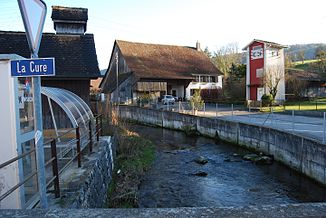
Scheltenbach in Courchapoix |
||
| Data | ||
| Water code | CH : 807 | |
| location | Switzerland | |
| River system | Rhine | |
| Drain over | Birs → Rhine → North Sea | |
| source | on Schöneberg above the Muelte farm in the community of Schelten 47 ° 19 ′ 28 ″ N , 7 ° 31 ′ 54 ″ E |
|
| Source height | approx. 1039 m above sea level M. | |
| muzzle | in Courroux in the Birs coordinates: 47 ° 21 '47 " N , 7 ° 22' 12" E ; CH1903: 594 809 / 245819 47 ° 21 '47 " N , 7 ° 22' 12" O |
|
| Mouth height | 410 m above sea level M. | |
| Height difference | approx. 629 m | |
| Bottom slope | approx. 32 ‰ | |
| length | 19.9 km | |
| Catchment area | 93.74 km² | |
| Discharge at the estuary A Eo gauge : 93.74 km² |
MQ Mq |
2.57 m³ / s 27.4 l / (s km²) |
| Left tributaries | Gabiare | |
| Right tributaries | Ruisseau de Montsevelier | |
| Communities | Schelten , Mervelier , Corban , Courchapoix , Val Terbi , Courroux | |
The Scheltenbach , or La Scheulte in French , is an approximately 20 km long right tributary of the Birs in the northern Jura in the Swiss cantons of Jura and Bern .
The Scheltenbach rises at about 1039 m above sea level. M. on the northern slope of the Schöneberg above the Muelte farm in the municipal area of the Bern exclave Schelten . After running 4.1 kilometers through the exclave, the river reaches the border with the canton of Jura. The upper reaches of the Scheltenbach lies in a deep valley between the mountain ranges of the northern chain Jura . After a gorge- like breakthrough between the heights of Le Chételat and Chaumont , the Scheltenbach reaches the depression of the Delsberg basin near the village of Mervelier .
It now flows further west in a broad, agriculturally intensively used valley basin, first taking in the Ruisseau de Montsevelier side stream from the right and then the Gabiare , the most important tributary, from the left . After a few bends in the plain of the Delsberg basin, the body of water called La Scheulte flows into the Birs near the village of Courroux, east of the Jura canton capital Delémont .
The upper reaches of the Scheltenbach are mostly natural or close to nature, while in the lower reaches it was channeled and built in to avoid the floods that used to occur, especially when the snow melted. In some places the water power of the Scheltenbach was used by mills.
Web links
Individual evidence
- ↑ a b c d Geoserver of the Swiss Federal Administration ( information )
- ↑ Modeled mean annual discharge. In: Topographical catchment areas of Swiss waters: sub-catchment areas 2 km². Retrieved October 20, 2016 .
