
Mont Raimeux
| Mont Raimeux | ||
|---|---|---|
 Raimeux summit with observation tower from the First World War |
||
| height | 1302 m above sea level M. | |
| location | Canton border Bern / Jura , Switzerland | |
| Mountains | law | |
| Dominance | 6.86 km → Hasenmatt | |
| Notch height | 533 m ↓ Gänsbrunnen | |
| Coordinates | 599 228 / 239 577 | |
|
||

The Mont Raimeux is a 1302 m high ridge in the Swiss Jura . The summit is on the border of the cantons of Bern and Jura , around 5 km northeast of Moutier . The mountain name is probably derived from the old French word raim , which roughly corresponds to the meaning of undeveloped land, covered with scrub or forest .
geography
The ridge of Mont Raimeux extends over a length of about 8 km in a west-east direction according to the general fold structure of the Jura in this region. On average it is around 3 km wide. The height of Mont Raimeux is limited in the south by the so-called Grand Val , the valley basin of Moutier, in the north by a syncline that stretches eastward from Rebeuvelier to Vermes . Both the western and the eastern delimitation are marked by characteristic Jurassic clusters . In the west are the Gorges de Moutier , through which the Birs flows, while in the east is the Envelier gorge. A 5 km long and on average 1 km wide plateau stretches out on Mont Raimeux, rising slightly towards the north and north-west.
geology
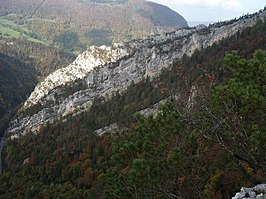
The structural geological structure of Mont Raimeux is relatively complicated. The ridge is part of the Folded Jura and is made up of two close-by anticlines that are excellently exposed in the Birs valley. The Combe du Pont forms the narrow syncline in between, which rises sharply to the east. The upcoming competent rock layers of the Upper Jurassic ( Malm ) are responsible for the relief of Mont Raimeux. By erosion of the hard was limestone in the apex region of the two anticlines partially removed so that the underlying softer shales and marls the Effingerschichten been exposed. The main ridge on which the canton border runs represents the rest of the northern anticline that plunges to the south.
The striking rock formations of Mont Raimeux, several of which are used as climbing rocks, include:
- the vertically erected limestone rocks of the Kimmeridgia and Rauracien in the Gorges de Moutier (southern anticline)
- the rugged Arête du Raimeux , limestone cliffs of the Kimmeridgien, southern leg of the northern anticline
- the rugged Roche Saint-Jean , limestone cliffs of the Kimmeridgia, northern limb of the northern anticline
- the Rochers du Droit on the southern slope of Mont Raimeux above Grandval , limestone cliffs of the Kimmeridgien, in the lower part vertically sloping banked limestone; in the upper part the layers run horizontally.
use
The steep flanks of Mont Raimeux are covered with thick beech and fir forests. On the high plateau there are extensive Jura high pastures, which are delimited by the typical dry stone walls. The three small hamlets Raimeux de Corcelles ( 1110 m above sea level ), Raimeux de Crémines ( 1116 m above sea level ) and Raimeux de Grandval ( 1288 m above sea level ) consist of mountain farms, horse pastures, individual holiday homes and one each Mountain restaurant.
There is an observation tower at the highest point of the mountain.
The 3.2 km long Tunnel du Raimeux of the A16 motorway runs beneath the western flank of the mountain and bypasses the narrow point of the Gorges de Moutier. The opening took place on November 30, 2007.
Gorges de Moutier with Raimeuxgrat

Raimeuxhütte of the SAC

View to the southeast

View from Mont Raimeux in northwest direction from the observation tower

Gorges de Moutier - view from Mont Raimeux


