
Mümliswil-Ramiswil
| Mümliswil-Ramiswil | |
|---|---|
 |
|
| State : |
|
| Canton : |
|
| District : | Thal |
| BFS no. : | 2428 |
| Postal code : | 4717 Mümliswil 4719 Ramiswil |
| UN / LOCODE : | CH MLW (Mümliswil) |
| Coordinates : | 620 006 / 243395 |
| Height : | 556 m above sea level M. |
| Height range : | 516–1204 m above sea level M. |
| Area : | 35.48 km² |
| Residents: | 2441 (December 31, 2018) |
| Population density : | 69 inhabitants per km² |
| Website: | www.muemliswil-ramiswil.ch |
 Mümliswil |
|
| Location of the municipality | |
  |
|
Mümliswil-Ramiswil is a municipality in the Thal district in the canton of Solothurn in Switzerland .
geography

Mümliswil lies at 556 m above sea level. M. , 3 km north of the district capital Balsthal ( linear distance ). The Haufendorf extends in a valley at the confluence of Ramiswiler Bach , Limmer Bach and Rickenbächli , at the upper entrance to the Klus of Lobisei , on the southern foot of the heights of the Passwang in the Solothurn Jura .
With an area of 35.5 km², Mümliswil-Ramiswil has the largest municipality in the canton of Solothurn. It covers the entire catchment area of the Guldental , a long valley in the Solothurn Jura. The western section of the area belongs to the Guldental, which is drained by the Ramiswil brook, the municipality's largest river. The broad valley depression is embedded between the anticlines of the Passwang range in the north and the Brunnersberg range in the south. Especially in its upper part, the valley cross-section has a clearly asymmetrical shape. The northern slope of the valley (the so-called Sunnenberg ) is very steep, densely forested and partially crossed by ledges. In contrast, the southern slope of the valley ( Schattenberg ) has smaller slopes, extensive pastures and protrusions. The southern boundary of the municipality is usually not on the watershed of the Brunnersberg range (at the Kleiner Brunnersberg 1,100 m above sea level ), but is slightly shifted towards the Guldental. The Scheltenpass ( 1051 m above sea level ), which connects to the Delsberg basin, forms the western end of the Guldental valley and the municipality .
Over time, the Limmerenbach has created a large evacuation basin in the Passwang chain. It flows through a gorge from the north into the basin of Mümliswil. In the area of the headwaters of this stream are the highest elevations in the community, namely the Passwang (Vogelberg) ( 1204 m above sea level ), the Rotisegg ( 1160 m above sea level ) to the south and the Chellenchöpfli ( 1157 m above sea level ) . ). A small part of the municipal ban lies north of this ridge in the headwaters of the Lüssel and the Hinteren Frenke .
From the east the Rickenbächli flows into the Mümliswil basin. It rises on the Breitehöchi , a pass crossing between the heights of Helfenberg ( 1124 m above sea level ) in the north and Beretenchopf ( 1104 m above sea level ) in the south, and geologically, forms the eastern continuation of the synclines of the Guldental.
The three streams converge near Mümliswil. The river, now called Mümliswiler Bach , breaks through in the Klus von Lobisei, a typical Jura cross valley with rugged rockfalls, the anticline of the Hauenstein chain between the Oberberg and the Beretenchopf and reaches the Balsthalertal at the Neu-Falkenstein ruins (just outside the municipality). In 1997, 5% of the municipal area was accounted for by settlements, 45% for forests and woodlands and 50% for agriculture.
The community consists of the settlement focus Mümliswil ( 556 m above sea level ) in the basin north of the Klus von Lobisei, the farming village Ramiswil ( 637 m above sea level ) in the Guldental at the southern foot of the Passwang, the hamlet Reckenchien ( 689 m above sea level) . ) on the lower southern slope of Rotisegg as well as numerous groups of courtyards and individual courtyards that are widely scattered in the valley basin and on the Jura heights. Neighboring communities of Mümliswil-Ramiswil are Holderbank , Balsthal , Laupersdorf , Matzendorf , Aedermannsdorf and Beinwil in the canton of Solothurn and Lauwil , Reigoldswil , Waldenburg and Langenbruck in the canton of Basel-Landschaft .
politics
executive
The executive consists of a 9-member municipal council (including the mayor), the seats are distributed as follows:
| Political party | 2017-2021 |
| Christian Democratic People's Party | 5 |
|
FDP The Liberals
|
2 |
| Swissical People's Party | 2 |
Mayor
Kurt Bloch (CVP) has been the mayor of Mümliswil-Ramiswil since 1998.
population
| Population development | |
|---|---|
| year | Residents |
| 1850 | 1580 |
| 1900 | 1820 |
| 1950 | 2680 |
| 1980 | 2386 |
| 2000 | 2582 |
| 2010 | 2526 |
With 2,441 inhabitants (as of December 31, 2018), Mümliswil-Ramiswil is one of the medium-sized communities in the canton of Solothurn. Around 400 of them live in Ramiswil. 93.5% of the residents speak German, 2.7% speak Serbo-Croatian and 1.4% speak Albanian (as of 2000).
The population of Mümliswil-Ramiswil was 1580 in 1850 and 1820 in 1900. In the course of the 20th century, the population rose continuously to 2714 people until 1960. Due to the economic crisis there was a strong emigration during the 1970s, the population decreased by 12% to 2386 people by 1980. Since then, a slight increase in population has been recorded.
economy
Mümliswil-Ramiswil used to be a predominantly agricultural village. However, various branches of industry developed early on. A paper mill was founded in Mümliswil as early as 1562 and ceased operations around 1840. From this paper factory a card factory emerged (manufacture of playing cards). During the 19th century, trimmings , which were initially mainly carried out at home and later also in a ribbon factory, became very important. A comb-making shop founded in 1783 developed into the municipality's most important employer at the end of the 19th century. However, the factory buildings were destroyed by an explosion on September 15, 1915, in which 32 workers were killed.
Because of the large municipal area, arable farming and fruit growing (in the lower elevations) as well as dairy farming and cattle breeding still play an important role in the income structure of the population. Numerous other jobs are available in local small businesses and in the service sector. In Mümliswil today there are companies in the building trade, plastics processing, electrical engineering, furniture industry, filter and membrane technology companies and various trading companies.
In the last few decades the village has also developed into a residential community. Extensive new residential quarters were created on the sunny southern slopes on both sides of the Limmerental. Many employed people are therefore commuters who mainly work in the Balsthal region and in the larger towns at the southern foot of the Jura.
traffic
Although the community is relatively isolated, it is still very well developed in terms of transport. It is located on the main road from Oensingen via Balsthal and Passwang to Laufental and Basel . The closest connection to the A1 motorway (Bern-Zurich) is around 8 km from the town center. The community is connected to the public transport network through a post bus course , which covers the route from Balsthal to Ramiswil and partly goes to the top of the Passwangstrasse. In 1873 construction work began on the Wasserfallen railway project between Reigoldswil and Mümliswil , but it failed. The work was stopped again in 1874.
history
The two villages Mümliswil and Ramiswil were probably founded by the Alemanni in the 7th and 8th centuries AD. Mümliswil was first mentioned in a document in 1145 under the name Mumliswilre . The names Mumeliswile (1194), Mivmeliswile (1258), Mumbliswile (1260) and Mümliswile (1305) appeared later . This place name goes back to the Old High German personal name Munwalt and therefore means the Munwalt homestead . Only two years later, when Mümliswil was first mentioned , Rammolswlare 1147 was first documented in the documents. Then the spellings Rammolswilare (1152), Ramolwire (1194) and Ramiswil (1372) appeared, which means the court settlement of the Hrabanwalt .
Mümliswil and Ramiswil have belonged to the Buchsgau since the 11th century and were therefore initially under the diocese of Basel before they came as a fiefdom to the Counts of Frohburg in the 12th century . Later the villages came under the rule of Neu-Falkenstein, which Solothurn bought with all rights in 1420. Mümliswil and Ramiswil were assigned to the Landvogtei Falkenstein and the court place Balsthal.
After the collapse of the Ancien Régime (1798), both villages were assigned to the Balsthal-Thal district. Mümliswil experienced a certain prosperity in the 19th century through its trade (combing, trimmings). Mümliswil and Ramiswil have formed a political unit since ancient times. In Ramiswil, however, there were efforts to break away from Mümliswil, but this was rejected in a vote in 1834 in both villages.
Attractions

- The Swiss Comb Museum has been located in Mümliswil since 1991 . In addition to tools and documents from the Mümliswil comb factory, which was closed in 1990, it shows all types of combs and various hair accessories.
- On June 1, 2013 - initiated by the Guido Fluri Foundation - the first national memorial for home and contracted children was opened in the former cooperative children's home of the Swiss Coop . The house was built in 1938–39 by the Swiss Bauhaus architect Hannes Meyer as a recreation and holiday home and is now a listed building.
- A mill from the end of the 16th century with a richly decorated gable front has been preserved in Ramiswil.
Churches
The core of the Sankt-Martins-Kirche in Mümliswil goes back to a medieval building. The Catholic parish church was given its present form when it was rebuilt in 1932. The baroque altars were integrated from the previous building ; The Wendelin altar is located in a side chapel. The church of St. Nicholas dates from 1869. In Ramiswil, which has had its own parish since 1856, there is the Catholic parish church of St. Urs and Viktor, built in 1869. There are various chapels in the municipality, namely the Fatima Chapel (1957) in Reckenchien, the modern Holy Blood Chapel on Passwang, the Kirschenhof Chapel from the 17th century, the St. Josef Chapel (1905) in Limmerental and the St. Wendelins Chapel (from 1672).
coat of arms
- Split by yellow with a black bishop's staff, the right-hand curvature decorated with an initial M and two-fold division of black, white and red
The colors black-white-red go back in reverse order to the coat of arms of the barons of Bechburg , which today also serves as the coat of arms of the Gäu district.
photos

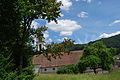
Village center of Mümliswil
Church of Mümliswil

Interior view of the Mümliswil church

Ramiswil Church

Interior view of the Ramiswil church


sons and daughters of the town
- Wolfgang Strähl (1807–1872), pianofortemaker, member of the League of Outlaws
- Elvira Bader (born March 4, 1955), educator, farmer and politician
literature
- Gottlieb Loertscher: The art monuments of the canton of Solothurn, Volume III: The districts of Thal, Thierstein, Dorneck. (= Art Monuments of Switzerland. Volume 38). Edited by the Society for Swiss Art History GSK. Bern 1957, DNB 750089342 .
Web links
- Official website of the Mümliswil-Ramiswil community
- Urs Wiesli: Mümliswil-Ramiswil. In: Historical Lexicon of Switzerland .
Individual evidence
- ↑ Permanent and non-permanent resident population by year, canton, district, municipality, population type and gender (permanent resident population). In: bfs. admin.ch . Federal Statistical Office (FSO), August 31, 2019, accessed on December 22, 2019 .
- ^ Community Mümliswil-Ramiswil Online: Community Council / Commissions. Retrieved October 9, 2018 .
- ^ Community Mümliswil-Ramiswil Online: Politics. Retrieved October 9, 2018 .
- ^ First national memorial for home and contract children