
Width
| Width | |||
|---|---|---|---|
| Compass direction | west | east | |
| Pass height | 845 m above sea level M. | ||
| Canton | Solothurn | Basel-Country | |
| Watershed | Rickenbächli → Mümliswiler Bach → Augstbach → Dünnern → Aare → Rhine | Vordere Frenke → Frenke → Ergolz → Rhine | |
| Valley locations | Mümliswil | Langenbruck | |
| expansion | Pass road | ||
| Winter closure | No | ||
| Mountains | Folded Jurassic | ||
| profile | |||
| Ø pitch | 7% (289 m / 4.1 km) | 6.3% (114 m / 1.8 km) | |
 |
|||
| Map (Solothurn) | |||
|
|||
| Coordinates | 622 908 / 244402 | ||

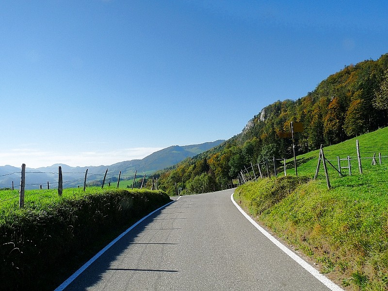
The Breitehöchi is a pass at 845 m above sea level. M. at the eastern exit of the Guldental in the canton of Solothurn in Switzerland .
The pass road leads on a side road from Mümliswil ( 556 m ) in the canton of Solothurn over the Sebleten and past the Breiten ( 740 m ) to the Breitehöchi ( 845 m ), then immediately passes the border to the canton of Basel-Landschaft and continues via Bachtelen ( 806 m ) and Fraurüti ( 740 m ) to Langenbruck ( 731 m ). A large part of today's route runs on traffic routes from the historical inventory . The pass connects the Passwang with the Obere Hauenstein and leads between the Helfenberg ( 1124 m ) in the north and the Beretenchopf ( 1104 m ) in the south past the Helfenbergflue ( 966 m ) through a landscape of national importance in the Folded Jura .
Web links
- Photo of the Breitehöchi on the alternatives-wandern.ch website
Individual evidence
- ↑ Inventory of the historical traffic routes in Switzerland (Federal Roads Office FEDRO) ( page no longer available , search in web archives ) Info: The link was automatically marked as defective. Please check the link according to the instructions and then remove this notice. , IVS object: SO 653, route: Mümliswil - Langenbruck, meaning (NHG): local, degree of substance: historical course with substance.
- ↑ Inventory of the historical traffic routes in Switzerland (Federal Roads Office FEDRO) ( page no longer available , search in web archives ) Info: The link was automatically marked as defective. Please check the link according to the instructions and then remove this notice. , IVS object: BL 606, route: Langenbruck - Breitenhöchi (- Mümliswil SO), meaning (NHG): local, degree of substance: historical course with substance.
- ↑ Federal Inventory of Landscapes and Natural Monuments of National Importance (BLN) (Federal Office for the Environment FOEN) , object name: Belchen-Passwang-area, object number 1012.

Ächerli • Agites • Aiguillon • Albis • Albula • Balmberg • Benkerjoch • Bernina • Böhler • Bözberg • Breitehöchi • Brünig • Buechenegg • Bürersteig • Chall • Challhöchi Pass • Champex • Chasseral • Chatzenstrick • Chilchzimmersattel • Croix • Croix • Croix de Coeur • Eichhöhe • Étroits • Etzelpass • Flüela • Forclaz • Furka • Ghöch • Givrine • glass • Glaubenberg • Glaubenbielen • Gottschalkenberg • Grimsel • Grosse Scheidegg • Gr.St.Bernhard • Gurnigel • Haggenegg • Hahnenmoos • Heitersberg • Hilferen • Hirzel • Hirzel Höhi • Hulftegg • Ibergeregg • Jaman • Jaun • Julier • Kerenzerberg • Klausen • Kunkels • Lein • Lenzerheide • Livigno • Lukmanier • Maloja • Marchairuz • Mollendruz • Mont Crosin • Monte Ceneri • Mont d'Orzeires • Montvoie • Morgins • Mosses • Mutschellen • Neggia • Nufenen • Oberalp • upper Hauenstein • Oberricken • oven • Orn • Passwang • Pierre Pertuis • Pillon • Planches • Pontins • Pragel • edge crossing • Rangiers • rates • Rengg • crocheted • Roches • 'groups • R üsler • Saanenmöser • Salhöhe • San Bernardino • Sanetsch • Santelhöchi • Sattel • Sattelegg • Schafmatt • Schallenberg • Schelten • Schönau • Schufelberger Egg • Schwägalp • Schwarzenbühl • Siblingerhöhe • Simplon • Splügen • St. Anton • St. Gotthard • St. Luzisteig • Staffelegg • Stoss • Susten • Tourne • Tronc • Umbrail • Unterer Hauenstein • Front Höhi • Vue des Alpes • Wasserfluh • Weissenstein • Wildhaus • Wissegg • Wolfgang