Ornpass
| Ornpass | |||
|---|---|---|---|
|
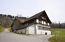
Orn, top of the pass |
|||
| Compass direction | northwest | Southeast | |
| Pass height | 925 m above sea level M. | ||
| Canton | Canton Zurich | Canton Zurich | |
| Valley locations | Wernetshausen | Forest ZH | |
| expansion | Pass road | ||
| Mountains | Zurich Oberland | ||
| profile | |||
| Ø pitch | 10% (200 m / 2 km) | 7.7% (306 m / 4 km) | |
| Map (Zurich) | |||
|
|
|||
| Coordinates | 709 297 / 238597 | ||
The Ornpass is a pass in the Swiss canton of Zurich in the municipality of Hinwil between Wernetshausen and Wald ZH . The pass is at an altitude of 925 m above sea level. M. on the southern slope of the Bachtel ( 1115 m ).
The hamlet of Orn lies on the Ornpass , 350 meters further south on the mountain slope of the hamlet of Niderorn.
In the Orn, a road branches off at the top of the pass that leads north to the summit of the Bachtel. To the southwest of the pass lies the Hochwacht hill ( 950 m ), on the northern slope of which the “Bachtel ski jump ” was formerly located.
The upstream line , a high-voltage overhead line , runs over the Ornpass .
Web links
Individual evidence
- ↑ Motorcycle and tours: Orn
- ↑ Wandersite.ch: Hasenstrick - Orn - Bachtel
- ^ Charles Knapp, Maurice Borel, Victor Attinger, Heinrich Brunner, Société neuchâteloise de geographie (editor): Geographical Lexicon of Switzerland . Volume 3: Krailigen - Plentsch . Verlag Gebrüder Attinger, Neuenburg 1905, p. 680, keyword Orn, (Nieder and Ober) ( scan of the lexicon page ).
- ↑ National map. In: geo.admin.ch. Federal Office of Topography swisstopo, accessed on July 23, 2020 ( Ort Orn (ZH) - Hinwil).
- ↑ Hinwil. In: Ski jumping hill archive. Retrieved July 23, 2020 .


