Heitersberg (pass)
| Heitersberg | |||
|---|---|---|---|
|
Pass height |
|||
| Compass direction | east | west | |
| Pass height | 657 m above sea level M. | ||
| Canton | Aargau | ||
| Watershed | → Limmat → Aare → Rhine | → Reuss → Aare → Rhine | |
| Valley locations | Spreitenbach | Remetschwil | |
| expansion | Side street | ||
| Built | ? | ||
| Lock | direct crossing prohibited | ||
| Mountains | Heitersberg | ||
| profile | |||
| Ø pitch | 3.6% (163 m / 4.5 km) | 7.3% (256 m / 3.5 km) | |
| Max. Incline | 17% | 10% | |
| Map (Aargau) | |||
|
|
|||
| Coordinates | 668 509 / 252007 | ||
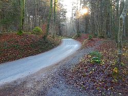
The Heitersberg is a pass in the Swiss canton of Aargau . It leads from Spreitenbach in the Limmattal over the southern part of the Heitersberg range of hills to Oberrohrdorf in the Reuss valley and overcomes an altitude of 657 m above sea level. M. It is one of two passes over the Heitersberg , along with the Rüsler, which is also blocked for passage .
The east ramp from Spreitenbach has a gradient of up to 17%, the west ramp from Oberrohrdorf up to 10%. Motorized traffic can reach the top of the pass from both sides, but direct crossing is prohibited.


