
Heitersberg
| Heitersberg | ||
|---|---|---|
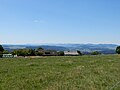
 View from Heitersberg into the Limmat Valley towards Zurich |
||
| height | 787 m above sea level M. | |
| location | Canton of Aargau and Canton of Zurich , Switzerland | |
| Dominance | 9.9 km → Lägern | |
| Notch height | 249 m ↓ Bonstetten | |
| Coordinates | 668 368 / 251384 | |
|
||

The Heitersberg is an elongated chain of hills in the central Swiss plateau . It is located in the east of the canton of Aargau , extends over a distance of around 13 km approximately in a north-south direction and reaches a height of up to 787 m above sea level. M. In the west it is bounded by the Reuss valley , in the east by the Limmattal and the Reppischtal . Most of it is forested, and some cleared areas are used for agriculture and grazing. A pass path, which is also called Heitersberg, leads over it.
geography

The northern end of the range of hills is in Baden near Chrüzliberg ( 514 m above sea level ). This is followed in a southerly direction by the Baregg ( 531 m above sea level ), the Oberhau ( 619 m above sea level ), the Rüslerhau ( 640 m above sea level ), the Sennenberg ( 702 m above sea level ), the actual Heitersberg ( 787 m above sea level ) and finally the Hasenberg ( 762 m above sea level ). The latter falls down to the 551 meter high Mutschellen Pass , the transition to the subsequent Holzbirrliberg . While the western flank of the range of hills generally slopes gently, the eastern flank is characterized by steeply sloping and deeply cut stream valleys. Two prehistoric landslide areas are characteristic, the Teufelskeller am Baregg and the Egelsee in a swampy depression on the steep flank of the actual Heitersberg.
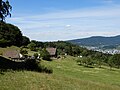
There are only a few hamlets on the chain of hills: Rüsler in the municipality of Neuenhof ( 632 m above sea level ), Sennenberg in the municipality of Killwangen ( 658 m above sea level ), Heitersberg in the municipality of Spreitenbach ( 648 m above sea level ), Sennhof in the municipality of Remetschwil ( 664 m above sea level ), Oberschönenberg in the municipality of Bergdietikon ( 671 m above sea level ) and Hasenberg in the municipality of Widen ( 696 m above sea level ). The villages of Oberrohrdorf , Remetschwil and Bellikon are located on a terrace above the Reuss valley .

The hamlet of Heitersberg
The hamlet of Sennhof
The hamlet of Rüsler


traffic
The Heitersberg range of hills stands in the way of traffic in the Central Plateau, which mainly runs in a west-east direction. It is crossed by a few streets, all of which, however, are closed to motorized through traffic and rarely have a hard surface. The most famous road leads from Oberrohrdorf over the Heitersberg to Spreitenbach. There is also a second road between Oberrohrdorf over the Rüsler to Neuenhof. In the past, through traffic required a detour via Baden in the far north or via the Mutschellen Pass in the far south. The A1 motorway has been running through the 1.1 km long Baregg Tunnel between Dättwil and Neuenhof since October 1970 . In June 2003, a third was added to the original two tunnel tubes. In May 1975 the 4.9 km long railway tunnel was opened between Mellingen and Killwangen, which forms part of the Heitersberg line .
Web links
Individual evidence
- ↑ a b Topographic maps 1: 25,000, sheets 1070 Baden and 1090 Wohlen
- ↑ Baregg-Info , June 1998 edition, Building Department of the Canton of Aargau
- ↑ Aargauer Zeitung : Baregg relieves the region , December 31, 2008