
Bergdietikon
| Bergdietikon | |
|---|---|
 |
|
| State : |
|
| Canton : |
|
| District : | to bathe |
| BFS no. : | 4023 |
| Postal code : | 8962 |
| UN / LOCODE : | CH BGI |
| Coordinates : | 671 531 / 249029 |
| Height : | 508 m above sea level M. |
| Height range : | 404–787 m above sea level M. |
| Area : | 5.94 km² |
| Residents: | 2833 (December 31, 2019) |
| Population density : | 477 inhabitants per km² |
|
Proportion of foreigners : (residents without citizenship ) |
17.8% (December 31, 2019) |
| Website: | www.bergdietikon.ch |
 |
|
| Location of the municipality | |
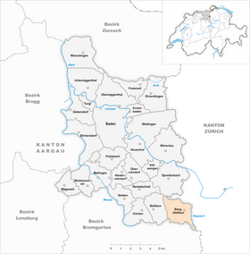  |
|
Bergdietikon (in local dialect : [ ˌb̥ɛɾg̊ˈd̥iə̯tikχə ]) is a municipality in the Swiss canton of Aargau . It belongs to the Baden district and is located southeast of the district capital on the border with the canton of Zurich .
geography
The municipality of Bergdietikon is made up of the villages of Baltenschwil ( 450 m above sea level ), Bernold ( 500 m above sea level ) and Kindhausen ( 581 m above sea level ) and the hamlets of Gimmern ( 530 m above sea level ), Herrenberg ( 618 m above sea level ), Oberschönenberg ( 671 m above sea level ) and Unterschönenberg ( 591 m above sea level ) together. These settlements are scattered on the eastern slope of the Heitersberg above the Zurich municipality of Dietikon in the Limmat Valley . In the northwest, at an altitude of 667 meters, is the Egelsee , surrounded by steep, wooded slopes , the largest natural lake located entirely on Aargau soil. The municipality is traversed by the Dönibach and extends in the southeast into the Reppischtal .
The municipal area is 594 hectares , 166 hectares of which are wooded and 112 hectares are built over. The highest point is at 787 meters on the Heitersberg, the lowest at 420 meters on the Reppisch. Neighboring communities are Spreitenbach in the north, Dietikon in the east, Urdorf in the southeast, Rudolfstetten-Friedlisberg in the south, Widen in the southwest and Bellikon in the west.
history

In 1973 a powerful cultural layer with numerous Roman ceramic shards was found in a sewer ditch. The scattered hamlets on the eastern slope of the Heitersberg had been part of the Dietikon judicial district since the Middle Ages . Baltenschwil was first mentioned in 1124 in a document issued by Emperor Heinrich V , which confirmed the interest income of the Engelberg monastery . Next to the monastery Muri especially was Wettingen Abbey a major landowner. The castle Kindhausen was probably in the first half of the 12th century by the Lords of Schönenwerd, servants counts of Kyburg and later the Habsburgs built, and in 1200 destroyed by fire.
In 1415 the Swiss conquered Aargau and Bergdietikon now belonged to the Dietikon office in the county of Baden , a common rule . In 1529 the Reformation was introduced . In contrast to other communities in the County of Baden, the Bergdietiker were not forced to return to the old faith after the Second Kappel War of 1531; the proximity to the city of Zurich may have played a role here. The first school existed in Eichholz in 1637.
In March 1798 the French took Switzerland and proclaimed the Helvetic Republic . The hamlets belonged to the municipality of Dietikon in the short-lived canton of Baden . In 1803 Napoleon Bonaparte ordered the creation of the canton of Aargau in the mediation act . Dietikon was separated: While the stately settlement in the Limmat Valley now belonged to the canton of Zurich, the widely scattered hamlets on the Heitersberg came to the canton of Aargau and formed the mountain community of Dietikon , called Bergdietikon since 1840.
The decentralized settlement structure made the development of the new municipality difficult. The communal facilities such as schools and administration were scattered over the whole commune area and the number of inhabitants rose only very slowly. After 1960, Bergdietikon changed from a poor farming community to an attractive residential area that attracted wealthy taxpayers in particular. The population has since increased more than six times. In 1960 the reformed church Bergdietikon was built .
Attractions


There are two castle ruins in the municipality of Bergdietikon. While individual wall sections of Kindhausen Castle have been preserved, the remains of the Hasenburg ruins are no longer visible.
coat of arms
The blazon of the municipal coat of arms reads: "In white on a green three-mountain, torn green oak with green fruits." This coat of arms was shown for the first time in 1872 on the official municipal seal. The oak motif was chosen because the community leaders allegedly used to live in the Eichholz farm. The Dreiberg is to be understood as an indication of the hilly location of the municipality.
population
The population developed as follows:
| year | 1780 | 1850 | 1900 | 1930 | 1950 | 1960 | 1970 | 1980 | 1990 | 2000 | 2010 |
| Residents | 361 | 491 | 466 | 499 | 789 | 426 | 1077 | 1693 | 2194 | 2256 | 2384 |
On December 31, 2019, 2833 people lived in Bergdietikon, the proportion of foreigners was 17.8%. In the 2015 census, 33.2% described themselves as Reformed and 29.6% as Roman Catholic ; 37.2% were non-denominational or of another faith. In the 2000 census, 93.4% chose German as their main language, 1.3% each French and Italian and 0.9% English .
Politics and law
The assembly of those entitled to vote, the municipal assembly , exercises legislative power. The executing authority is the five-member municipal council . He is elected by the people in the majority procedure, his term of office is four years. The parish council leads and represents the parish. To this end, it implements the resolutions of the municipal assembly and the tasks assigned to it by the canton. The Baden District Court is responsible for litigation in the first instance . Bergdietikon belongs to the Friedensrichterkreis IV (Wettingen).
economy
According to the company structure statistics (STATENT) collected in 2015, Bergdietikon has around 1,100 jobs, of which 5% in agriculture, 50% in industry and 45% in the service sector. Almost all companies are domiciled in the industrial zone in the somewhat remote Reppischtal. Soudronic , a company specializing in welding technologies, has its headquarters there. Many workers are commuters and work in the communities of the Limmat Valley or in the city of Zurich .
traffic
The Bergdietikon settlements are connected to Dietikon by a strait . A side road leads from Baltenschwil to Widen , which is often used as a secret route when traffic jams on the main road over the Mutschellen . Baltenschwil, Bernold and Kindhausen are connected by a bus line from Limmat Bus to Dietikon train station , where there is a connection to the Zurich S-Bahn . Another line leads to Spreitenbach and is mainly used for school traffic. Despite its location in the canton of Aargau, Bergdietikon is part of the Zürcher Verkehrsverbund . The industrial zone in the Reppischtal is accessed through the Reppischhof stop of the Bremgarten-Dietikon-Bahn . On weekends there is a night bus from Dietikon to Kindhausen.
education
All school facilities are located in the centrally located district of Bernold. The kindergarten and primary school are located there . The Realschule , the Secondary School and the District School can be attended in Spreitenbach . The closest grammar schools are the Baden Cantonal School and the Wettingen Cantonal School .
Personalities
- Gerhart Isler (* 1949), publicist
literature
- Anton Wohler: Bergdietikon. In: Historical Lexicon of Switzerland .
- Peter Hoegger: The art monuments of the canton of Aargau . Ed .: Society for Swiss Art History . Volume VII: District of Baden II. Birkhäuser Verlag, Basel 1995, ISBN 3-909164-44-7 , p. 5-11 .
- Patrick Zehnder: Crossing borders - The Aargau municipality of Bergdietikon since the Middle Ages . Chronos-Verlag, Zurich 2003, ISBN 3-0340-0582-2 .
Web links
Individual evidence
- ↑ Cantonal population statistics 2019. Department of Finance and Resources, Statistics Aargau, March 30, 2020, accessed on April 2, 2019 .
- ↑ Cantonal population statistics 2019. Department of Finance and Resources, Statistics Aargau, March 30, 2020, accessed on April 2, 2019 .
- ↑ a b Beat Zehnder: The community names of the canton of Aargau . Historical sources and linguistic interpretations. In: Historical Society of the Canton of Aargau (Ed.): Argovia . Annual journal of the Historical Society of the Canton of Aargau. tape 100 / II . Verlag Sauerländer, Aarau 1991, ISBN 3-7941-3122-3 , p. 80 f . The phonetic transcription used : bę̀rgdį́ə̯tị̀kxə .
- ↑ a b Gabrielle Schmid: Bergdietikon AG (Baden) In: Dictionnaire toponymique des communes suisses - Lexicon of Swiss municipality names - Dizionario toponomastico dei comuni svizzeri (DTS | LSG). Center de dialectologie, Université de Neuchâtel, Verlag Huber, Frauenfeld / Stuttgart / Vienna 2005, ISBN 3-7193-1308-5 and Éditions Payot, Lausanne 2005, ISBN 2-601-03336-3 , p. 141. The phonetic transcription given: [ ˌBɛrgˈdiətikχə ].
- ^ National map of Switzerland, sheet 1090, Swisstopo.
- ↑ Standard area statistics - municipalities according to 4 main areas. Federal Statistical Office , November 26, 2018, accessed on June 2, 2019 .
- ^ Martin Hartmann, Hans Weber: The Romans in Aargau . Verlag Sauerländer, Aarau 1985, ISBN 3-7941-2539-8 , p. 165 .
- ^ Joseph Galliker, Marcel Giger: Municipal coat of arms of the Canton of Aargau . Lehrmittelverlag des Kantons Aargau, book 2004, ISBN 3-906738-07-8 , p. 115 .
- ↑ Population development in the municipalities of the Canton of Aargau since 1850. (Excel) In: Eidg. Volkszählung 2000. Statistics Aargau, 2001, archived from the original on October 8, 2018 ; accessed on June 2, 2019 .
- ↑ Resident population by religious affiliation, 2015. (Excel) In: Population and Households, Community Tables 2015. Statistics Aargau, accessed on June 2, 2019 .
- ↑ Swiss Federal Census 2000: Economic resident population by main language as well as by districts and municipalities. (Excel) Statistics Aargau, archived from the original on August 10, 2018 ; accessed on June 2, 2019 .
- ↑ circles of justice of the peace. Canton of Aargau, accessed on June 18, 2019 .
- ↑ Statistics of the corporate structure (STATENT). (Excel, 157 kB) Statistics Aargau, 2016, accessed on June 2, 2019 .
Bathing | Bellikon | Bergdietikon | Birmenstorf | Things of honor | Ennetbaden | Fislisbach | Freienwil | Gibstorf | Killwangen | Künten | Mellingen | Mägenwil | Neuenhof | Niederrohrdorf | Oberrohrdorf | Obersiggenthal | Remetschwil | Spreitenbach | Stetten | Turgi | Untersiggenthal | Wettingen | Wohlenschwil | Würenlingen | Würenlos
Former municipalities: Büblikon | Dättwil | Kempfhof | Oberehrendingen | Oetlikon | Rohrdorf | Unterehrendingen
Canton of Aargau | Districts of the Canton of Aargau | Municipalities in the Canton of Aargau