
Urdorf
| Urdorf | |
|---|---|
 |
|
| State : |
|
| Canton : |
|
| District : | Dietikon |
| BFS no. : | 0250 |
| Postal code : | 8902 |
| UN / LOCODE : | CH URD |
| Coordinates : | 674 687 / 248 928 |
| Height : | 416 m above sea level M. |
| Height range : | 394–597 m above sea level M. |
| Area : | 7.58 km² |
| Residents: | 9848 (December 31, 2018) |
| Population density : | 1299 inhabitants per km² |
|
Proportion of foreigners : (residents without citizenship ) |
24.2% (December 31, 2018) |
| Mayor : | Sandra Rottensteiner ( EVP ) |
| Website: | www.urdorf.ch |
 reformed Church |
|
| Location of the municipality | |
  |
|
Urdorf is a municipality in the Dietikon district in the canton of Zurich in Switzerland . On 1 January 1931 the former municipality was Oberurdorf with low Urdorf to the municipality of Urdorf merged .
geography
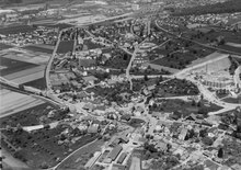
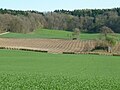
Urdorf is located southwest of the Schlieren municipality, which is part of the settlement area of the city of Zurich , in a valley formed by the Reuss glacier through which the Schäflibach flows. Erratic boulders made of reddish rock prove that an arm of the Linth glacier must have penetrated this area at times. Through the deposited moraine rubble , the Reppisch washed out an incision behind the Honeret and the Egg, the Reppisch valley. There is also the highest point in Urdorf, 587 m above sea level. M. high Hohbüel . Of the community area, 32.2% is agricultural land, 32.2% is forest, 26.4% is settlement area and 8.1% is used for transport, 0.3% is water and 0.8 is unproductive areas (as of 2007) .
history
A Bronze Age settlement on Rainweg (Moosmatt) and the mansion of a Roman manor (Heidenkeller, Oberurdorf) from the 1st century indicate early settlement. The Celtic Helvetii inhabited this area before it became part of the Roman Empire .
The place name Urdorf appears in today's spelling for the first time in a document from 1124. In 1179, Konrad von Sellenbüren mentions Urdorf in the foundation deed of Engelberg Monastery by Konrad von Sellenbüren, along with other localities. The chapel of St. Georg in the Reppischtal (abandoned during the Reformation) was first reported in 1173 and the chapel of St. Niklaus (today the old Reformed church) in Oberurdorf in 1184.
In the late Middle Ages, Oberurdorf consisted of the Meierhof of the St. Blasien monastery , the mill on the Römerenbach ( Schäflibach ) and a tavern, while Niederurdorf was just a small hamlet. In 1526, the Mayor of Zurich, Hans Steiner, built today's Wirtschaft zur Sonne as a bathing and spa house. With the Landbad Oberurdorf experienced a certain heyday in the 17th century. The county of Baden exercised the high court over the whole area, but lent it as judicial bailiff to the Regensbergers and until 1384 to Habsburg-Laufenburg .
From 1487 the city of Zurich gradually acquired this fiefdom and added it to its upper bailiwick in Birmensdorf. The lower jurisdiction was conferred by the Habsburgs to the Lords of Schönenwerd until around 1450 , changed hands several times and came into the possession of the Steiner von Uitikon family from 1620 to 1798 . Since the 14th century, village openings have summarized the applicable regulations and standards and were binding legal statutes until 1798.
As early as 1830, the Zurich Great Council wanted to merge Ober- and Niederurdorf. The community of Niederurdorf resisted and argued that the village had "eighty citizens who were able to vote and in their midst enough men of understanding to be able to fill the community offices with the same". Zurich finally gave in. It was not until a hundred years later, in 1930, that the voters of Oberdorf and Niederurdorf decided to merge to form the municipality of Urdorf, which was carried out in 1931. Originally Ober- and Niederurdorf were assigned to the district of Horgen , in 1803 a change took place to the district of Zurich and on July 1, 1989 Urdorf was assigned to the newly founded district of Dietikon .
The population increased steadily from 1467 with approx. 80 to 1634 with 581 inhabitants and then remained practically constant (1850 with 770, 1900 with 711). In the 1950s (1,929) and 1960s (3,909) the growth spurt began as an agglomeration municipality in the city of Zurich (8,589 in 1980, 9,417 in 2000). With the construction of the Dietikon-Birmensdorf cantonal road from 1848 to 1850, settlement development shifted from the village stream to the new traffic artery. The Zurich-Affoltern railway on the Albis-Zug , the so-called Ämtlerbahn or Knonauerstrecke, began operations in 1864 with, among other things, the Urdorf station in the neighboring municipality of Schlieren.
With the population growth, the various ties to Dietikon were gradually dissolved:
- 1958 own secondary school
- 1959 own Reformed parish
- 1960 own Catholic parish
Pastor Ernst Sieber ran an open addiction support facility for drug addicts in Urdorf from 1996–2009. In the industrial area of Urdorf, in the border triangle to Schlieren and Dietikon, is the Limmattal Cantonal School , opened in 1977 , whose catchment area includes the Dietikon district and the Säuliamt .
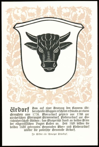
coat of arms
- A black bull's head looking forward in silver.
The oldest surviving representation of the Urdorf symbol, the "Stieregrind", shows the four-community boundary stone from 1778 in the sand hole.
population
With 9,848 inhabitants (as of December 31, 2018) Urdorf is one of the medium-sized communities in the canton of Zurich .
- Population density: 1249.1 inh. / Km 2
- Number of households: 4,406 (as of 2010)
- Denomination: 32.1% Protestant Reformed , 35.1% Roman Catholic , 32.8% other or no denominational affiliation (status: 2010)
politics
The SVP has 33.7%, the SP 18.9%, the FDP 9.2%, the GLP 9.1%, the CVP 6.9%, the Greens 5.3% and the EPP 2.4% of the Votes.
Attractions
The Urdorfer Senke was fortified together with the Oberurdorf local base as part of the Limmat position during World War II . It formed an important blocking point to prevent the enemy from advancing into the Reuss valley in the direction of Gotthard. The three-kilometer-wide section of the 6th Division between Uetliberg, Waldegg and Urdorfer Senke consisted of a deep system of alternating positions that began on the Limmat and ended behind the Reppisch. A tank barrier with 18 concreted weapon stands, which are still in place today, ran through the open Urdorf depression.
The Brother Klaus Church was built in 1964.
Personalities
- Rudolf Pfister (1909–2000), Protestant clergyman and university professor; lived and died in Urdorf
- Hans Falk (1918–2002), painter and graphic artist; lived in Urdorf
- Eugenio A. Beltrami (1930–1995), Italian inventor and motorcycle racer; lived in Urdorf
- Jürg Marquard (* 1945), publisher
- Barbara Angelsberger (* 1951), politician (FDP); lives in Urdorf
- Stefan Burkart (1957–2020), track and field athlete and Olympic participant; born in Urdorf
- Helen Barnett-Burkart (* 1958), British-Swiss athlete and Olympian; lived in Urdorf
- Jean-Claude Leclercq (* 1962), French cyclist; spent part of his childhood in Urdorf
- Marco Schönbächler (* 1990), soccer player
photos

Urdorf local museum

Hardship

Old school house from 1838
Part of the Urdorfer Senke: Tank barrier with machine gun bunker and shield for infantry cannon

Tank wall of the Oberurdorf local base

Viergemeindenstein in the sand hole near Uitikon


literature
- Elisabeth Lüchinger-Grob: Urdorf in old views. European Library 2002, ISBN 978-90-288-6701-7
- Karl Grunder: The Art Monuments of the Canton of Zurich Volume 9: The Dietikon District. Edited by the Society for Swiss Art History GSK. Bern 1997 (Art Monuments of Switzerland Volume 88). ISBN 3-909164-57-9 . Pp. 338-366.
- Maximilian Georg Kroiß: Holy Brother Klaus Urdorf ZH in 2013. A young parish from 1960 with old roots from 1173. Urdorf 2013.
Web links
- Martin Illi: Urdorf. In: Historical Lexicon of Switzerland .
- Official website of the municipality of Urdorf
- Statistical data for the municipality of Urdorf
Individual evidence
- ↑ Permanent and non-permanent resident population by year, canton, district, municipality, population type and gender (permanent resident population). In: bfs. admin.ch . Federal Statistical Office (FSO), August 31, 2019, accessed on December 22, 2019 .
- ↑ Data on the resident population by home, gender and age (community profile). Statistical Office of the Canton of Zurich, accessed on December 22, 2019 .
- ↑ Community portrait : Detailed history of Urdorf
- ^ Chronicle of the local museum foundation and the Urdorf local history association . accessed on January 18, 2018
- ^ Antiquarian Society, Zurich . accessed on January 18, 2018
- ^ Statistical Office of the Canton of Zurich - database (community portraits) . accessed on January 14, 2014
- ↑ http://www.europese-bibliotheek.nl/en/books/Urdorf_in_alten_Ansichten/100-208010/Article
Aesch | Birmensdorf | Dietikon | Geroldswil | Oberengstringen | Oetwil on the Limmat | Streaks | Uitikon | Unterengstringen | Urdorf | Weiningen
Former municipalities: Niederurdorf | Oberurdorf
Canton of Zurich | Districts of the Canton of Zurich | Municipalities of the Canton of Zurich