Geroldswil
| Geroldswil | |
|---|---|
| State : |
|
| Canton : |
|
| District : | Dietikon |
| BFS no. : | 0244 |
| Postal code : | 8954 |
| UN / LOCODE : | CH GDW |
| Coordinates : | 673 358 / 252926 |
| Height : | 395 m above sea level M. |
| Height range : | 380-583 m above sea level M. |
| Area : | 1.93 km² |
| Residents: | 4958 (December 31, 2018) |
| Population density : | 2316 inhabitants per km² |
|
Proportion of foreigners : (residents without citizenship ) |
26.2% (December 31, 2018) |
| Mayor : | Michael Deplazes ( independent ) |
| Website: | www.geroldswil.ch |
| Location of the municipality | |
Geroldswil is a municipality in the Dietikon district in the canton of Zurich in Switzerland .
geography
The community is located in the Limmat Valley at an altitude of 395 m above sea level. M. , bordering the Limmat to the north and extends up to the southern slope of the Altberg, at the foot of which is the Wiesentäli. The highest point in the community is 583 m above sea level. M. high Hasleren .
Around 26.7% of the municipal area is agricultural land, the larger forest areas on the Altberg make up 23.6%, the water area 3.1%. 36.1% of the settlement area is zoned (92.8% of which is overbuilt), a further 7.9% are used as traffic areas.
Neighboring communities are Oetwil an der Limmat , Weiningen and Dietikon .
history
Geroldswil is first mentioned in 1255 as Geroltzwiler and Geroltiswiler . This is followed by 1264 and 1293 Gerolzwile , 1332 Geroltswile , 1417 and 1442 Gerentswil , 1443 Gerottschwil , 1450 Geroltzswile , 1468 Geratschwil , 1590 Geeretschwiil & Gerolschwil , 1630 Geeretschwyl , 1842 Geroldsweil and 1850 Geroldschwyl . The current name is first mentioned in 1470.
coat of arms
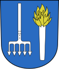
- In blue, in front of a silver torch with golden fire, a downward-facing silver Fischger with five barbs
The Geroldswiler coat of arms was first found on fire brigade buckets from 1834 and indicates the salmon fishing practiced by the villagers in the Limmat.
population
| Population development | |
|---|---|
| year | Residents |
| 1634 | 56 |
| 1799 | 137 |
| 1850 | 194 |
| 1900 | 141 |
| 1950 | 441 |
| 1960 | 844 |
| 1970 | 2818 |
| 2000 | 4540 |
economy
Geroldswil is the seat of the steel group Sipro .
church
The Roman Catholic Church of St. John is located in Geroldswil . It was built as part of the realization of the village center by the architect Walter Moser in 1972.
Attractions
literature
- Karl Grunder: The Art Monuments of the Canton of Zurich Volume 9: The Dietikon District. Edited by the Society for Swiss Art History GSK. Bern 1997 (Art Monuments of Switzerland Volume 88). ISBN 3-909164-57-9 . Pp. 144-150.
Web links
- Official website of the Geroldswil municipality
- Statistical data of Geroldswil municipality
- Martin Illi: Geroldswil. In: Historical Lexicon of Switzerland .
Individual evidence
- ↑ Permanent and non-permanent resident population by year, canton, district, municipality, population type and gender (permanent resident population). In: bfs. admin.ch . Federal Statistical Office (FSO), August 31, 2019, accessed on December 22, 2019 .
- ↑ Data on the resident population by home, gender and age (community profile). Statistical Office of the Canton of Zurich, accessed on December 22, 2019 .
- ↑ Geroldswil on Ortsnames.ch
- ↑ History of Geroldswil on gerodswil.ch


