
Dietikon
| Dietikon | |
|---|---|
 |
|
| State : |
|
| Canton : |
|
| District : | Dietikon |
| BFS no. : | 0243 |
| Postal code : | 8953 |
| UN / LOCODE : | CH THE |
| Coordinates : | 672 858 / 251005 |
| Height : | 388 m above sea level M. |
| Height range : | 379–653 m above sea level M. |
| Area : | 9.34 km² |
| Residents: | 27,265 (December 31, 2018) |
| Population density : | 2589 inhabitants per km² |
|
Proportion of foreigners : (residents without citizenship ) |
45.4% (December 31, 2018) |
| City President : | Roger Bachmann ( SVP ) |
| Website: | www.dietikon.ch |
 Dietikon and the Limmattal , in the background Schlieren and Zurich |
|
| Location of the municipality | |
  |
|
Dietikon (in local dialect : [ ˈd̥iə̯tikχə / ˈtiə̯tikχə ]) is a political municipality and capital of the district of the same name in the canton of Zurich in Switzerland . Dietikon had a population of 27,000 at the end of 2016. With the strong economic development of the Limmat Valley since the end of the Second World War , the city became a city in the agglomeration of Zurich . Due to the brisk construction activity, the two formerly separate villages of Dietikon Unterdorf and Dietikon Oberdorf grew together. Inhabitants of Dietikon are called dieticians. Dietikon should not be confused with the almost homophonic political community Dietlikon in the Bülach district east of the city of Zurich.
geography
The industrial city of Dietikon is located west of the city of Zurich at 388 m above sea level. M. at the confluence of the Reppisch and Limmat and on the railway line from Zurich to Baden . The large Limmattal marshalling yard is also located here and in the neighboring town of Spreitenbach . Approx. 25% (2.3 km²) of the area is forest. The largest and best known are Honeret, Guggenbüel and Röhrenmoos.
Honeret:
The Honeret lies on a lateral moraine of the Linth glacier . There are therefore over 200 striking stones and boulders up to 25 m² in size (boulders). The Honeret and the Guggenbüehl forest are only separated from each other by a main road. In the forest there are some springs from which the Tobelbach and Stoffelbach streams emerge and then flow into the Reppisch. The forest hut Lorenzhütte is located in the forest.
Guggenbüehl:
The Guggenbüehl is entirely in Dietikon. The Giigelibode pond is in the forest . It has neither inflows nor outflows. There is a Vita Parcours in the forest .
Grien Island:
The Grien Island lies between the Limmat in the east and a canal of the Dietikon power plant (electricity works of the Canton of Zurich) in the west.
Important bodies of water that flow through Dietikon are the Limmat and its tributary Reppisch as well as the approximately 6 kilometers long Schäflibach and Teischlibach . The Teischlibach rises in the Röhrenmoos forest above Dietikon and also flows into the Limmat. The marble pond is located in the Grunschen , a playground and barbecue area. The Marble Pond is an artificial pond that was created to supply the fire brigade with extinguishing water. For this purpose, a diversion channel was built at the Grunschen . The pond was later used by a marble factory. This is what gave it its name.
history
The finds that were made in the Schächteli allow the conclusion that the area was already populated in the Neolithic Age (5500-2400 BC). Settlement during the Bronze Age can be proven with grave finds on the Honeret and in the former village center. Graves from the Iron Age have also been found, which can be ascribed to the Hallstatt and Latène periods .
From AD 20 to around AD 320 there was a large Roman estate in the area of today's city center. It covered at least an area of 13,000 square meters and was at least 212 × 600 meters in size. The manor was surrounded by a wall, the height of which is estimated to be one meter. In the south-east of the area there was a villa area, the extent of which towards the Limmat is unclear. It is also assumed that there was a landing stage for ships on the Limmat. The manor was largely destroyed by fire in the middle of the 3rd century. The manor was on the Roman road from Lake Zurich via Baden to Vindonissa .
The settlement in the early Middle Ages is proven by graves from the 7th century. Based on the pit houses , which were located in the area of the Catholic Church, it must be assumed that there has been continuous settlement since the 10th century. In the chronicle of 1135 written by Ortlieb, Dietikon is mentioned for the first time in the description of the Bempflingen Treaty . It says there that Kuno von Wülflingen bequeathed to Dietinchovin "a quarter of the village, church and Limmatfischenz as well as Salland in a total of 12 Huben" to the Zwiefalten monastery, which he founded . The place name consists of the Old High German personal name Dioto, extended by the suffix -ing- and the appended basic word hof in the plural dative ( * Diotinc-hovun > Dietikon ) and means something like 'at the courtyards of the Dioto clan'.
The monastery sold its property in Dietikon as early as 1096 to the wife of Count Otto von Habsburg , the dynasty that briefly owned the entire village (Unter- and Oberdorf) and all of their property in Dietikon (Unterdorf) and Schlieren sold to Wettingen Monastery in 1259 for 540 marks. The Habsburgs retained the county rights ( high court ), customs, patronage and the bailiwick of the church. As employers of the Habsburgs, the knights of Schönenwerd moved into Schönenwerd Castle on the Limmat. Even after Dietikon was sold, they exercised the bailiwick rights over Dietikon-Oberdorf, which was then considered a separate bailiwick. Here on the Reppisch the knights owned a sizable property. The Wettingen monastery gradually succeeded in buying the possessions in the upper village from the impoverished knights. The bailiwick rights of both Dietikons did not come to the monastery until 1367. Within a century, the monastery succeeded in acquiring an almost closed area with all rights around Dietikon, so that one can speak of a Dietikon rule. The monastery then shaped the village. As the legal successor to the secularized monastery, the canton of Aargau sold the Dietikon church treasure to the Zurich stand . The contract for this was signed on March 3rd and 17th. Only after the Reformation did Zurich slowly make itself felt.
The county rights, and thus the high court, were initially with the Habsburgs until the Confederates conquered Aargau in 1415 . Until 1798 Dietikon belonged to the Landvogtei Baden and was therefore part of the County of Baden and the common rulership of eight places (after 1712 only Zurich, Bern, Glarus). After the French invaded, the canton of Baden of the Helvetic Republic was founded on April 11, 1798 , to which Dietikon also belonged. On September 25, 1799, the place was the scene of the Limmat crossing of the French . When the Helvetic Republic was dissolved on March 10, 1803, Dietikon became part of the Canton of Zurich. Between 1815 and 1832 the community belonged to the Zurich Oberamt and from 1832 to the Zurich district . On July 1, 1989, the Dietikon district was split off from the Zurich district and Dietikon was named the district capital.
In 1939 the center of Dietikon was expanded with bunkers and a concrete ring wall into an important base, the so-called Dietikon Fortress , the position of the Limmat . In 1940 it was inspected several times by General Henri Guisan . The central school building served as a mobilization space. It was surrounded by defensive walls and bunkers. Soldiers were quartered, changing of the guard and main reading took place in the playground. Parts of the Dietiker fortifications have been preserved to this day - including two longer pieces of the former fortress wall in the middle of the city.
coat of arms
- In blue, a vertical silver rod ending in a lily at the top and bottom.
population
| Population development | |
|---|---|
| year | Residents |
| 1779 | 686 |
| 1836 | 1,025 |
| 1850 | 1,292 |
| 1900 | 2,613 |
| 1910 | 4,493 |
| 1950 | 7,358 |
| 1960 | 14,758 |
| 1970 | 22,391 |
| 1980 | 22,297 |
| 1990 | 21,130 |
| 2000 | 21,089 |
| 2002 | 21,743 |
| 2003 | 21,904 |
| 2004 | 21,822 |
| 2007 | 22,497 |
| 2009 | 23,106 |
| 2018 | 27,146 |
| 2019 | 27,661 |
27,265 people live in Dietikon (as of December 31, 2018). 40.57 percent of the residents registered in Dietikon, that is 9,812 people, do not have a Swiss passport. In 2011, 15.4 percent of the population were younger than 15 years (that is 3,719 children) and 5.3 percent of the population were young people, i.e. between 15 and 19 years (that is, 1,284). Around 62.19 percent of the population are between 20 and 64 years old (15'059). 16.04 percent of the population were older than 64 years (that is 4,121 people).
Languages and Social
The official and lingua franca is German, which is spoken predominantly as Zurich German in everyday life .
In October 2009, according to the statistical office of the canton of Zurich, 701 people were registered as unemployed in Dietikon. This corresponds to an unemployment rate of 5.6 percent. The proportion of women in Dietikon in 2009 was 49.9 percent.
Religions and denominations
The Roman Catholic denomination is the largest religious group with 33.2 percent, followed by the Evangelical Reformed Church with 14.9 percent (as of 2016).
There are six Christian communities in Dietikon:
- The Roman Catholic Church of St. Agatha is at the train station. It was built from 1925 to 1927 by the well-known architect Adolf Gaudy . Its predecessor was the medieval church , which was used equally .
- The Church of St. Josef is the second Roman Catholic church in Dietikon and is located in the east on Urdorferstrasse . The church, built in 1968, was consecrated to St. Joseph.
- The reformed church was built on Sonneggstrasse after the end of the equal use of the medieval church in 1925 .
- At the Austrasse standing Apostolic Church .
- The Christian center Silbern belongs to the Pentecostal movement and can be found on Riedstrasse .
- The MovementPlus Dietikon is located on Bremgartnerstrasse .
The Islamic community recorded strong growth in Dietikon : The number of Muslims rose to 12.2 percent. More and more people in Dietikon describe themselves as non-denominational; the share of those with no religious affiliation (9.4 percent) and those without a denomination (4.6 percent) was 14 percent in 2000.
Attractions
The ruins of the Schönenwerd moated castle are located on the Limmat .
The Roman Catholic Church of St. Agatha , which was built between 1925 and 1927 according to plans by Adolf Gaudy , is the most visible building in today's city center. Behind her is the Catholic rectory (Bahnhofplatz 3A), which was built in 1833. The reformed church was built away from the village center. It is located on the Kirchhalde and was built between 1924 and 1925 according to plans by Emil Schäfer. Before that there was a parity church in Dietikon , the Church of St. Ulrich and St. Agatha, which was then demolished. The Bruno Weber Park at the Dietikon town hall is also very popular and the 80 meter high Limmat Tower has established itself as a new landmark in Dietikon in the Limmatfeld. It was completed in 2015.
Outside
The Fahr Benedictine monastery, which dates back to the 12th century, is an enclave of the canton of Aargau and has a monastery church from 1743 to 1746 that is well worth seeing

Erdhaussiedlung Lattenstrasse by Peter Vetsch

Limmatwehr
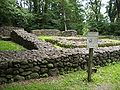
Schönenwerd moated castle 12th century

Dietikon Fortress 1939/40

Tavern zur Krone, first mentioned in 1259

Roman manor with an area of 13 hectares
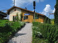
Station building Dietikon of the Spanish-Brötli-Bahn from 1847

Dietikon, aerial photo from 1919, taken from a height of 300 meters by Walter Mittelholzer

Dietikon and Limmattal, aerial photo from 1930, taken by Walter Mittelholzer


traffic
The road from Zurich to Baden has passed through the district of Dietikon-Unterdorf since the Middle Ages. As far as it can be reconstructed, it follows the old Roman road and, like this one, crosses the Reppisch. The main road over the Mutschellen, which leads from Zurich to Bremgarten, was built between 1840 and 1841. The municipality has owned the Dietikon train station since 1847 , although the first station building from 1847 has been preserved. With the opening of the Bremgarten-Dietikon-Bahn, it became a transfer station. The Glanzenberg train station is also part of the city of Dietikon, where the Zurich S-Bahn also stops. There are also four further train stops operated by BDWM Transport AG: Schöneggstrasse, Bergfrieden, Stoffelbach and Repischhof. With the opening of the A1 motorway in 1970, the full connection to Dietikon was also created. The regional bus transport is carried out by the Limmat Bus company.
Together with the second generation of the Zurich S-Bahn, a new station is to be built in the Silbern industrial area. The largest Tesla location in Switzerland to date was opened there in May 2019, with 24 Tesla Superchargers and a lounge , etc. a. with drinks machine , catering machine and game console , opened.
politics
City president has been Roger Bachmann ( SVP ) since 2018
The legislature is the local council with 36 seats. The graphic on the right shows the distribution of seats after the election on March 4, 2018.
In the 2019 National Council elections, the share of the vote in Dietikon was: SVP 32.7%, SP 18.0%, Greens 10.7%, CVP 10.5%, glp 10.4% FDP 9.3%, EVP 4.0% , AL 1.3%, BDP 1.0%.
Town twinning
Personalities
- Karl Frehsner (* 1939), ski trainer, called "iron Karl"
- Peter Schweri (1939–2016), Swiss painter, draftsman and object artist
- Rosmarie Frehsner (* 1942), former Cantonal Councilor (SVP)
- Nikolaus Göldlin von Tiefenau (1625–1686), pastor, abbot of Tennenbach and Wettingen
- Hanspeter Müller-Drossaart (* 1955), actor
- Fintan Mundwiler (1835–1898), Swiss-American Benedictine abbot
- Markus Notter (* 1960), former mayor and councilor (SP) Kt. ZH
- Rolf Steiner (* 1952), Cantonal Councilor (SP), President of the Cantonal Council (2016/17)
- Hans Peter Trutmann, city historian
- Bruno Weber (1931–2011), architect and sculptor
- Peter Wiederkehr (* 1938), former government councilor Kt.ZH (CVP)
- Otto Müller (* 1953), Mayor 2006–2018 (FDP)
- Josef Wiederkehr (* 1970), entrepreneur and cantonal councilor
- Pasquale Aleardi (born 1971), actor
- Yves Müller (* 1989), ice hockey player
- Jeanne Pestalozzi , President of the Reformed Aid Organization "Bread for All"
- Xen (* 1990), rapper
- Rahel Kiwic (* 1991), Swiss football player
- Eseosa Aigbogun (* 1993), Swiss-Nigerian football player
- Theo Hitzig (Peter Winkler-Payot) (* 1968), comedian ( Lapsus )
- Dieter Pestalozzi , entrepreneur, company owner
literature
- Karl Grunder: The Art Monuments of the Canton of Zurich Volume 9: The Dietikon District. Edited by the Society for Swiss Art History GSK. Bern 1997 (Art Monuments of Switzerland Volume 88). ISBN 3-909164-57-9 . Pp. 98-143.
Web links
- Official website of the city of Dietikon
- Statistical data for the municipality of Dietikon
- Ursula Fortuna: Dietikon. In: Historical Lexicon of Switzerland .
Individual evidence
- ↑ Permanent and non-permanent resident population by year, canton, district, municipality, population type and gender (permanent resident population). In: bfs. admin.ch . Federal Statistical Office (FSO), August 31, 2019, accessed on December 22, 2019 .
- ↑ Data on the resident population by home, gender and age (community profile). Statistical Office of the Canton of Zurich, accessed on December 22, 2019 .
- ↑ a b Gabrielle Schmid: Dietikon ZH (Dietikon) In: Dictionnaire toponymique des communes suisses - Lexicon of Swiss community names - Dizionario toponomastico dei comuni svizzeri (DTS | LSG). Center de dialectologie, Université de Neuchâtel, Verlag Huber, Frauenfeld / Stuttgart / Vienna 2005, ISBN 3-7193-1308-5 and Éditions Payot, Lausanne 2005, ISBN 2-601-03336-3 , p. 297. The phonetic transcription used : [ ˈdiətikχə, ˈtiətikχə ].
- ^ Beat Zehnder: The community names of the canton of Aargau . Historical sources and linguistic interpretations. In: Historical Society of the Canton of Aargau (Ed.): Argovia . Annual journal of the Historical Society of the Canton of Aargau. tape 100 / II . Verlag Sauerländer, Aarau 1991, ISBN 3-7941-3122-3 , p. 80 f .
- ↑ Zurich Finance Protocols 1838, in the State Archives of the Canton of Zurich
- ↑ Inscription plaque at the tavern zur Krone, Dietikon: 1940 during the inspections of the Dietikon Fortress during World War II, General Guisan stayed as a guest at the Krone
- ↑ a b c d e f g Statistical data of the Dietikon municipality ( memento from June 16, 2009 in the Internet Archive ), accessed on February 14, 2011
- ↑ This is what the Zurich S-Bahn should look like in the future , Neue Zürcher Zeitung on January 12, 2018.
- ↑ Sibylle Egloff: Games console, table tennis and children's corner: the new Tesla location has it all. In: limmattalerzeitung.ch . May 10, 2019, accessed May 11, 2019 .
- ↑ Election protocol. (PDF) City of Dietikon, April 22, 2018, accessed on August 29, 2018 .
- ↑ Election protocol. (PDF) City of Dietikon, March 4, 2018, archived from the original on March 29, 2018 ; accessed on March 29, 2018 .
- ↑ Elections 2019. Retrieved November 25, 2019 .
Aesch | Birmensdorf | Dietikon | Geroldswil | Oberengstringen | Oetwil on the Limmat | Streaks | Uitikon | Unterengstringen | Urdorf | Weiningen
Former municipalities: Niederurdorf | Oberurdorf
Canton of Zurich | Districts of the Canton of Zurich | Municipalities of the Canton of Zurich