Unterengstringen
| Unterengstringen | |
|---|---|
| State : |
|
| Canton : |
|
| District : | Dietikon |
| BFS no. : | 0249 |
| Postal code : | 8103 |
| Coordinates : | 676 304 / 252068 |
| Height : | 416 m above sea level M. |
| Height range : | 383–612 m above sea level M. |
| Area : | 3.34 km² |
| Residents: | 3881 (December 31, 2018) |
| Population density : | 1162 inhabitants per km² |
|
Proportion of foreigners : (residents without citizenship ) |
24.9% (December 31, 2018) |
| Website: | www.unterengstringen.ch |
|
Unterengstringen, in the foreground the Fahr Monastery |
|
| Location of the municipality | |
Unterengstringen is a municipality in the Dietikon district in the canton of Zurich in Switzerland .
geography
Unterengstringen lies in the Limmattal at about 400 m above sea level. M. on the southern flank of the Altberg ridge.
The proximity to the city of Zurich and the good transport connections contribute to the fact that the location on the southern slope of the Gubrist appears to be a preferred residential area. The two groves on the Gubrist and in the Hard are popular recreational areas. Green belts, still operated as agricultural land, are one of these open spaces, which in the southern part of the municipality with the possessions of the Fahr Monastery and the Hardwald, expand to form a compact recreational zone along the Limmat .
coat of arms
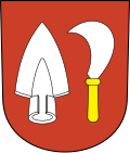
- In red a silver ploughshare in front of a silver vine knife with a gold handle.
population

The municipality has 2843 inhabitants in 1206 households (2002). Of these, 2,311 are Swiss and 532 are foreigners. The denominations were distributed as follows: Roman Catholic 1,003, Protestant Reformed 1,173, others 667.
Attractions
- The Glanzenberg ruin is located in the municipality , which includes a castle ruin and the desertification of the former town of Glanzenberg.
- The area of the Fahr Monastery is an enclave in Unterengstringen and belongs to the Aargau municipality of Würenlos .
literature
- Karl Grunder: The Art Monuments of the Canton of Zurich Volume 9: The Dietikon District. Edited by the Society for Swiss Art History GSK. Bern 1997 (Art Monuments of Switzerland Volume 88). ISBN 3-909164-57-9 . Pp. 295-337.
Web links
- Official website of the municipality of Unterengstringen
- Martin Illi: Unterengstringen. In: Historical Lexicon of Switzerland .
- Statistical data for the municipality of Unterengstringen
- Primary school Unterengstringen 1998: From the history of the Unterengstringen school
Individual evidence
- ↑ Permanent and non-permanent resident population by year, canton, district, municipality, population type and gender (permanent resident population). In: bfs. admin.ch . Federal Statistical Office (FSO), August 31, 2019, accessed on December 22, 2019 .
- ↑ Data on the resident population by home, gender and age (community profile). Statistical Office of the Canton of Zurich, accessed on December 22, 2019 .


