
Birmensdorf
| Birmensdorf | |
|---|---|
 |
|
| State : |
|
| Canton : |
|
| District : | Dietikon |
| BFS no. : | 0242 |
| Postal code : | 8903 |
| UN / LOCODE : | CH BDF |
| Coordinates : | 675 488 / 245 324 |
| Height : | 518 m above sea level M. |
| Height range : | 448–657 m above sea level M. |
| Area : | 11.42 km² |
| Residents: | 6519 (December 31, 2018) |
| Population density : | 485 inhabitants per km² |
|
Proportion of foreigners : (residents without citizenship ) |
24.4% (December 31, 2018) |
| Mayor : | Bruno Knecht (non-party) |
| Website: | www.birmensdorf.ch |
 Birmensdorf |
|
| Location of the municipality | |
  |
|
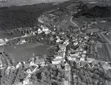
Birmensdorf is a municipality in the Dietikon district of the canton of Zurich in Switzerland , including the hamlet of Landikon . It should not be confused with the homophonic Birmenstorf in the canton of Aargau.
geography
Birmensdorf is located in the Reppisch Valley , in the middle of a wide basin. Several large brooks, including the Lunnerenbach and the Wüeribach , cross the valley floor and finally flow into the Reppisch. The valley basin lies on the west side of the Uetliberg and is open on several sides.
history
Traces of Stone Age settlement were discovered in the Filder region . Finds in Landikon and Risten date from Roman times .
Birmensdorf was first mentioned in a document as Piripoumesdorf in 876 , when a certain Adalpern donated part of his possessions to the Zurich Fraumünster .
The beginnings of the modern settlement lie at the river crossing of the road connection from Bremgarten to Zurich over the Reppisch. Stake finds from this point could be dated to approx. 610 AD.
In the 16th and 17th centuries, Birmensdorf was an Anabaptist center .
Large parts of Birmensdorf belonged to the St. Blasien monastery until its abolition in 1808 . In 1834, Birmensdorf became an independent municipality, first in the Horgen district in 1803, in the Zurich district in 1815 and finally in the Dietikon district in 1989 .
coat of arms
- A curly silver tip in red, topped with a red rose with a golden clasp and green sepals.
population
| Population development | |
|---|---|
| year | Residents |
| 1634 | approx. 460 |
| 1749 | 858 |
| 1836 | 1082 |
| 1850 | 1096 |
| 1900 | 1101 |
| 1950 | 1480 |
| 2000 | 5451 |
| 2009 | 5832 |
| 2012 | 5951 |
- Population density: 520.6 inhabitants / km 2
- Number of households: 2508 (as of 2000)
- Denomination: 35.6% Evangelical Reformed , 29.2% Roman Catholic , 35.2% other or no denomination (as of 2012)
economy
The proximity to the city and the good transport connections have shaped the development of Birmensdorf. Industrialization did not take place, an agglomeration community emerged with a high proportion of commuters, as well as a strong local commercial infrastructure.
traffic
Road traffic
Birmensdorf is located on the main axis through the Knonauer Amt into the greater Zurich area and is characterized by heavy rush hour traffic - thousands of commuters from Central Switzerland crossed the village every day, in the morning in a northerly direction and in the evening in a southerly direction. The community was relieved by the opening of the new section of the A4 motorway between Urdorf Süd and the Zurich West junction, which opened in April 2009.
The route of the motorway around Birmensdorf was argued for over 40 years and rescheduled several times. This section of the motorway therefore has a certain symbolic character for Swiss transport policy.
Public transport
Since June 1864, Birmensdorf has been on the Zurich – Zug railway line , which was opened by the Zurich-Zug-Lucerne Railway (ZZL). The railway line - now part of the Swiss Federal Railways (SBB) - has been used by the S9 of the Zurich S-Bahn since May 1990 . In addition, the S15 has been running since December 2006, which enables almost every quarter of an hour. After the new line initially only operated on working days until 8:00 p.m., its operating time was extended to 9:00 p.m. in December 2008 and extended to the weekend. Since December 2015, instead of the S9 and S15, the S5 and S14 have been serving Birmensdorf.
Since 2004, the Birmensdorf train station has been managed under private law by Luc Vuilleumier as the station owner . The station is frequented by over 5,000 travelers on weekdays.
Regional bus connections to Zurich-Wiedikon , Oberlunkhofen - Affoltern am Albis (215), Oberlunkhofen- Muri AG (245) and Oberwil-Lieli - Berikon (350) are provided by Postbuses every half hour. This means that between Birmensdorf and Oberlunkhofen there is an almost 15-minute service from Monday to Saturday. They run every hour on Sunday and after the evening. From Monday to Saturday, the 227 bus runs every hour to Stallikon - Bonstetten and the 314 bus runs to Dietikon during rush hour .
Public institutions
Weapons Square Zurich-Reppischtal
Since April 10, 1987, the location of the weapons field in Zurich has been in the Reppischtal. The facility, which is used for both basic military training and the WWI troops, is also an employer in Birmensdorf; among other things, apprentices are trained in civilian professions. Since 2006, the Military Academy at ETH Zurich (MILAK) has also been located on the Waffenplatz.
Research institute for forest, snow and landscape
The Federal Research Institute for Forests, Snow and Landscape (WSL) has its headquarters in Birmensdorf.
Attractions
The remains of a first church seem to date from the 9th century. It was a Romanesque St. Martin's church with a horseshoe-shaped apse . The founder of the church could have been a descendant of Uatilo vom Üetliberg , who later belonged to the barons of Regensberg - Sellenbüren . In the 11th century they gave the church Birmensdorf to the monastery of St. Blasien in the Black Forest, in whose possession it remained until 1806. During this time the three-storey Romanesque church tower was built, of which the lower storeys are still preserved today. In the 14th century, a Gothic choir was added instead of the Romanesque one, to which the enlarged nave with nave and choir was adapted in 1659.
The village museum on Mühlemattstrasse and the old water mill are well worth seeing.
Churches
There are two churches in Birmensdorf:
- The reformed church is located above the town center and goes back to the medieval St. Martin's church.
- The Roman Catholic Church of St. Martin was built in 1977 by the well-known church architect Walter Moser. It is located on the street Am Wasser .
Personalities
- Ferdy Kübler (1919–2016), racing cyclist and the first Swiss Tour de France winner, lived in Birmensdorf.
literature
- Karl Grunder: The Art Monuments of the Canton of Zurich Volume 9: The Dietikon District. Edited by the Society for Swiss Art History GSK. Bern 1997 (Art Monuments of Switzerland Volume 88). ISBN 3-909164-57-9 . Pp. 49-97.
Web links
- Official website of the community of Birmensdorf
- Official journal of the community of Birmensdorf
- Statistical data for the community of Birmensdorf
- Reinhard Möhrle: Birmensdorf (ZH, community). In: Historical Lexicon of Switzerland .
- Reinhard Möhrle: Birmensdorf (ZH, Vogtei). In: Historical Lexicon of Switzerland .
Individual evidence
- ↑ Permanent and non-permanent resident population by year, canton, district, municipality, population type and gender (permanent resident population). In: bfs. admin.ch . Federal Statistical Office (FSO), August 31, 2019, accessed on December 22, 2019 .
- ↑ Data on the resident population by home, gender and age (community profile). Statistical Office of the Canton of Zurich, accessed on December 22, 2019 .
- ↑ birmensdorf.ch: residents' statistics_2009.pdf (application / pdf-Objekt; 97 kB) , accessed on January 14, 2014
- ^ Statistical Office of the Canton of Zurich - database (community portraits) . accessed on January 14, 2014
- ^ [1] Prehistory of the Reformed Church
Aesch | Birmensdorf | Dietikon | Geroldswil | Oberengstringen | Oetwil on the Limmat | Streaks | Uitikon | Unterengstringen | Urdorf | Weiningen
Former municipalities: Niederurdorf | Oberurdorf
Canton of Zurich | Districts of the Canton of Zurich | Municipalities of the Canton of Zurich