Oberwil-Lieli
| Oberwil-Lieli | |
|---|---|
| State : |
|
| Canton : |
|
| District : | Bremgarten |
| BFS no. : | 4074 |
| Postal code : | 8966 |
| Coordinates : | 671 596 / 243331 |
| Height : | 565 m above sea level M. |
| Height range : | 444–677 m above sea level M. |
| Area : | 5.35 km² |
| Residents: | 2459 (December 31, 2019) |
| Population density : | 460 people per km² |
|
Proportion of foreigners : (residents without citizenship ) |
12.5% (December 31, 2019) |
| Website: | www.oberwil-lieli.ch |
|
Oberwil-Lieli |
|
| Location of the municipality | |
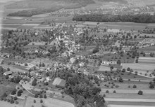
Oberwil-Lieli , in local Swiss German Oberwiil and Niel [ˌɔbərˈʋiːl], [niəl] , instead of the latter, younger [ˈliəlɪ] , is a municipality in the Swiss canton of Aargau . It belongs to the Bremgarten district , lies on the border with the canton of Zurich and consists of the villages of Oberwil and Lieli. Until 1984 the community was officially called Oberwil (AG) .
geography
The community is located on the Holzbirrliberg , a gently undulating range of hills east of the Reuss Valley . Oberwil is located in the southwest of the municipality on a hillside at 530 m above sea level. M. Three brooks that flow through deeply cut ravines drain the plateau towards the Reuss. The Buechimoos and Augenweid settlements have almost grown together with Oberwil. About one kilometer northeast of Oberwil, separated by the Falterhauwald, is the village of Lieli at 590 m above sea level. M. In the far east of the municipality which rises Lunnerenbach , in the Reppisch flows.
The area of the municipality is 535 hectares , of which 136 hectares are covered with forest and 101 hectares are built over. The highest point is at 674 m above sea level. M. in the Oberholz north of Lieli, the deepest at 450 m above sea level. M. in the Halden area south of Oberwil. Neighboring communities are Berikon in the north, Birmensdorf in the northeast, Aesch in the east, Arni in the southeast, Unterlunkhofen in the south and Zufikon in the west.
history
The first documentary mention of Willare took place in 1040, when King Henry III. the monastery of Einsiedeln confirmed his possession. The place name comes from the Old High German wīlari "Hofsiedlung" and was specified in the second half of the 13th century as Ober-Wiler . Lieli, older in dialect Niel, is also mentioned for the first time in 1040 as in Liele and comes from Old High German liola or Swiss German Niele, " common clematis (Clematis vitalba) ".
In the Middle Ages, Oberwil was under the rule of the House of Habsburg-Laufenburg . The Engelberg and Muri monasteries belonged to the feudal lords . In 1415 the Swiss conquered the Aargau, and Oberwil came to the cellar office within the rulership of the city of Zurich . In 1429 Bremgarten acquired lower jurisdiction . During the Old Zurich War , the Central Swiss devastated the village in 1445. In 1529 the residents converted to the Reformation , but had to return to Catholicism only two years later after the Second Kappel War . In the First Villmerger War of 1656, troops marching through looted the village again. After the conquest of Switzerland by the French and the proclamation of the Helvetic Republic in March 1798, the cellar office was dissolved. Oberwil and Lieli were communities in the short-lived canton of Baden , from 1803 they belonged to the canton of Aargau.
The village of Lieli was an independent municipality until 1908. Due to their poor financial situation, the Grand Council of the Canton of Aargau carried out the merger against the will of the population. The community was still called Oberwil. On January 1, 1984, however, she changed the name to Oberwil-Lieli in order to do justice to Lieli's growing importance. After the population had declined slightly in the first half of the 20th century, the community developed into a popular residential community from the 1960s due to its proximity to Zurich and the number of inhabitants quadrupled.
Attractions
The Catholic parish church of St. Michael in Oberwil dates back to the 11th century, from which time the Romanesque church tower has been preserved. In 1445 the church was set on fire during the Old Zurich War, and a new building was built in 1501. During the First Villmerger War, the church suffered heavy devastation. It received its current baroque appearance in 1672/73.
coat of arms
The blazon of the municipal coat of arms reads: "In white on a green three-mountain torn green pear tree with yellow fruits." The pear tree on the coat of arms, which has existed in this form since 1953, indicates the Holzbirrliberg. In 1915, the historian Walther Merz had unsuccessfully proposed to use the coat of arms of the von Wile family from Oberwil (white bar in red).
population
The population developed as follows:
| year | 1850 | 1900 | 1930 | 1950 | 1960 | 1970 | 1980 | 1990 | 2000 | 2010 | 2015 |
| Residents | 734 | 649 | 602 | 605 | 551 | 768 | 1191 | 1591 | 1729 | 2157 | 2459 |
On December 31, 2019, 2459 people lived in Oberwil-Lieli, the proportion of foreigners was 12.5%. According to data collected in 2015, 36.2% described themselves as Roman Catholic and 29.0% as Reformed ; 34.8% were non-denominational or of other faiths. In the 2000 census, 95.1% stated German as their main language, 1.1% Italian and 1.0% each English and French .
Politics and law
The assembly of those entitled to vote, the municipal assembly , exercises legislative power. The executing authority is the five-member municipal council . He is elected by the people in the majority procedure, his term of office is four years. The parish council leads and represents the parish. To this end, it implements the resolutions of the municipal assembly and the tasks assigned to it by the canton. The Bremgarten District Court is primarily responsible for legal disputes . Oberwil-Lieli belongs to the judges of peace VII (Bremgarten).
economy
According to the corporate structure statistics (STATENT) collected in 2015, Oberwil-Lieli has around 420 jobs, of which 17% in agriculture, 18% in industry and 65% in the service sector. Because of its attractive location, the community is primarily a residential area. Most of the employed work in Bremgarten or in the Zurich agglomeration . A particular locational advantage is the fact that Oberwil-Lieli has the lowest municipal tax rate in the entire canton.
traffic
While Oberwil is a bit away from through traffic on Kantonsstrasse 411, the busy Kantonsstrasse 263 runs through Lieli between Bremgarten / Mutschellen in the west and Zurich in the east. The volume of traffic has increased further since the opening of the nearby Zurich western bypass ( A4 motorway ). To protect the population from the harmful effects, a bypass tunnel was built under Lieli and has been in operation since April 2008.
Oberwil and Lieli are served by a post bus line that runs between Berikon - Widen station on the Bremgarten-Dietikon railway and Zurich Wiedikon station . There is also a Limmat Bus express bus from Bremgarten via Oberwil-Lieli and the Uetliberg tunnel to Zurich Enge station . On weekends, a night bus runs from Dietikon train station via Widen to Oberwil-Lieli.
education
The community has three kindergartens and one primary school , with the school building exactly in the middle between the two villages. The upper school students ( junior high school , secondary school and district school ) visit the district school center in neighboring Berikon . The closest grammar school is the Cantonal School in Wohlen .
Personalities
- Andreas Glarner (* 1962), politician
- Florian Jenni (* 1980), chess player
- Matthias Müller (* 1982), orienteer
literature
- Anton Wohler: Oberwil-Lieli. In: Historical Lexicon of Switzerland .
- Peter Felder: The art monuments of the canton of Aargau . Ed .: Society for Swiss Art History. Volume IV: Bremgarten district. Birkhäuser Verlag, Basel 1967, ISBN 3-906131-07-6 .
Web links
Individual evidence
- ↑ Cantonal population statistics 2019. Department of Finance and Resources, Statistics Aargau, March 30, 2020, accessed on April 2, 2019 .
- ↑ Cantonal population statistics 2019. Department of Finance and Resources, Statistics Aargau, March 30, 2020, accessed on April 2, 2019 .
- ↑ According to the material from the Linguistic Atlas of German-speaking Switzerland and the Wenker set completed on site .
- ↑ a b According to the lexicon of Swiss municipality names . Edited by the Center de Dialectologie at the University of Neuchâtel under the direction of Andres Kristol. Frauenfeld / Lausanne 2005, p. 673 f.
- ^ National map of Switzerland, sheets 1090 and 1091, Swisstopo.
- ↑ Standard area statistics - municipalities according to 4 main areas. Federal Statistical Office , November 26, 2018, accessed on May 14, 2019 .
- ^ Beat Zehnder: The community names of the canton Aargau (= Argovia 100 / II). Sauerländer, Aarau 1991, ISBN 3-7941-3122-3 , pp. 332–334.
- ^ The clematis or Nielen (Clematis). waldwissen.net, archived from the original on June 18, 2011 ; Retrieved January 15, 2010 .
- ↑ Fields: The Art Monuments of the Canton of Aargau, Volume IV: Bremgarten District. Pp. 341-349.
- ^ Joseph Galliker, Marcel Giger: Municipal coat of arms of the Canton of Aargau . Lehrmittelverlag des Kantons Aargau, book 2004, ISBN 3-906738-07-8 , p. 242 .
- ↑ Population development in the municipalities of the Canton of Aargau since 1850. (Excel) In: Eidg. Volkszählung 2000. Statistics Aargau, 2001, archived from the original on October 8, 2018 ; accessed on May 14, 2019 .
- ↑ Resident population by religious affiliation, 2015. (Excel) In: Population and Households, Community Tables 2015. Statistics Aargau, accessed on May 14, 2019 .
- ↑ Swiss Federal Census 2000: Economic resident population by main language as well as by districts and municipalities. (Excel) Statistics Aargau, archived from the original on August 10, 2018 ; accessed on May 14, 2019 .
- ↑ circles of justice of the peace. Canton of Aargau, accessed on June 19, 2019 .
- ↑ Statistics of the corporate structure (STATENT). (Excel, 157 kB) Statistics Aargau, 2016, accessed on May 14, 2019 .
- ↑ These are the tax hells and tax havens in Aargau. Aargauer Zeitung , January 27, 2015, accessed on May 14, 2019 .
- ↑ Tunnel opening in Lieli. Construction, Transport and Environment Department of the Canton of Aargau, April 18, 2008, accessed on January 15, 2010 .


