Uezwil
| Uezwil | |
|---|---|
| State : |
|
| Canton : |
|
| District : | Bremgarten |
| BFS no. : | 4078 |
| Postal code : | 5619 |
| Coordinates : | 663 189 / 240 939 |
| Height : | 528 m above sea level M. |
| Height range : | 508–631 m above sea level M. |
| Area : | 2.44 km² |
| Residents: | 491 (December 31, 2019) |
| Population density : | 201 inhabitants per km² |
|
Proportion of foreigners : (residents without citizenship ) |
9.4% (December 31, 2019) |
| Website: | www.uezwil.ch |
|
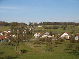
View of Uezwil |
|
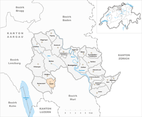
| Location of the municipality | |
Uezwil ( Swiss German : Üezmel, ˈʏətsməl ) is a municipality in the Swiss canton of Aargau . It belongs to the Bremgarten district and is located on the western edge of the Bünztal .
geography
The horseshoe-shaped village is located at the top of a wide plateau on the northernmost branch of the Lindenberg range of hills, which is called Niesenberg here. The plain is bounded by gently rising hills to the west, south and east, giving it a trough-like shape. It is drained to the north by the Hinterbach, a tributary of the Bünz .
The area of the municipality is 244 hectares , of which 68 hectares are covered with forest and 15 hectares are built over. The highest point is at 632 meters on the eastern slope of the Niesenberg, the lowest at 520 meters on the Hinterbach. Neighboring communities are Büttikon in the north, Waltenschwil in the northeast, Kallern in the east and south and Sarmenstorf in the west.
history
In 1936 a 4500 year old megalithic grave from around 2500 BC was found in the Eichenweid near Uezwil . To the fore. Further finds suggest a settlement during Roman times . Later, a settlement was Alemanni . When the Muri Monastery was founded in 1027, the name of a knight Arnold von Utwile was noted. Juezewile was first mentioned in a document in 1217. The place name comes from the Old High German Uozinwilari and means "court settlement of Uuzo". The spelling changed over the centuries via Uotzwile and Uetzwil to Uezwil.
The most important feudal lords in the Middle Ages were the Einsiedeln monastery , the Muri monastery , the Gnadenthal monastery and the Sarmenstorf parish . The Habsburgs were sovereigns and holders of blood jurisdiction . In 1415 the Lucerne population conquered the villages of Büttikon , Hilfikon , Sarmenstorf, Uezwil and Villmergen , but in 1425 they had to return the area to the common property of the Confederates . Uezwil was now in the office of Villmergen of the free offices , a common rule . The village always remained rural, and from the 18th century onwards, working from home enabled the straw industry to earn a modest amount of extra income.
In March 1798 the French took Switzerland and proclaimed the Helvetic Republic . Uezwil became a municipality in the Sarmenstorf district of the short-lived canton of Baden , since 1803 it has belonged to the canton of Aargau. To this day, Uezwil has remained a small village that is mainly characterized by agriculture ; notable industry has never settled here. After the number of inhabitants had always declined, it has increased again slightly since 1980.
Attractions
The Chapel of the Coronation of the Virgin Mary is in the middle village. It was built in 1766/67 instead of an older, dilapidated facility. It consists of a short nave , a recessed polygonal choir and a detached axial sacristy .
coat of arms
The blazon of the municipal coat of arms reads: "Split by yellow with three red arrowheads growing from the dividing line, and by blue." Since 1880 the municipality used a coat of arms with a bundle of lictors , under the false assumption that it was the Uezwil municipal coat of arms . In reality it was the seal of the Helvetic Republic introduced in 1798. The coat of arms redesigned in 1946 commemorates the church patronage of St. Sebastian .
population
The population developed as follows:
| year | 1850 | 1900 | 1930 | 1950 | 1960 | 1970 | 1980 | 1990 | 2000 | 2010 |
| Residents | 331 | 319 | 325 | 320 | 300 | 284 | 276 | 331 | 361 | 417 |
On December 31, 2019, 491 people lived in Uezwil, the proportion of foreigners was 9.4%. In the 2015 census, 53.9% described themselves as Roman Catholic and 18.6% as Reformed ; 27.5% were non-denominational or of other faiths. 97.5% said German as their main language in the 2015 census .
Politics and law
The assembly of those entitled to vote, the municipal assembly , exercises legislative power. The executing authority is the five-member municipal council . He is elected by the people in the majority procedure, his term of office is four years. The parish council leads and represents the parish. To this end, it implements the resolutions of the municipal assembly and the tasks assigned to it by the canton. The Bremgarten District Court is primarily responsible for legal disputes . Uezwil belongs to the Friedensrichterkreis VI (Wohlen).
economy
According to the company structure statistics (STATENT) collected in 2015, there are around 80 jobs in Uezwil, 48% of them in agriculture, 6% in industry and 46% in the service sector. Most of the employed are commuters and work in the neighboring communities, mainly in Wohlen and Villmergen .
traffic
Uezwil is a little off the main traffic routes and therefore has almost no through traffic. The main road 25 between Lenzburg and Zug is only a few kilometers away. The village is connected to the Wohlen train station via a post bus line.
education
The community has a kindergarten and a school house where primary school is taught. All upper levels of the compulsory elementary school ( Realschule , Secondary School , District School ) can be attended in Wohlen . The nearest grammar school is also located there, the Wohlen Cantonal School .
Personalities
- Roland Koch (born May 29, 1959 in Uezwil), actor, director and ensemble member at the Vienna Burgtheater
literature
- Anton Wohler: Uezwil. In: Historical Lexicon of Switzerland .
- Peter Felder: The art monuments of the canton of Aargau . Ed .: Society for Swiss Art History . Volume IV: Bremgarten district. Birkhäuser Verlag, Basel 1967, ISBN 3-906131-07-6 .
Web links
Individual evidence
- ↑ Cantonal population statistics 2019. Department of Finance and Resources, Statistics Aargau, March 30, 2020, accessed on April 2, 2019 .
- ↑ Cantonal population statistics 2019. Department of Finance and Resources, Statistics Aargau, March 30, 2020, accessed on April 2, 2019 .
- ↑ a b Beat Zehnder: The community names of the canton of Aargau . In: Historical Society of the Canton of Aargau (Ed.): Argovia . tape 100 . Verlag Sauerländer, Aarau 1991, ISBN 3-7941-3122-3 , p. 430-431 .
- ^ National map of Switzerland, sheet 1110, Swisstopo.
- ↑ Standard area statistics - municipalities according to 4 main areas. Federal Statistical Office , November 26, 2018, accessed on May 15, 2019 .
- ↑ Fields: The Art Monuments of the Canton of Aargau, Volume IV: Bremgarten District. Pp. 382-384.
- ^ Joseph Galliker, Marcel Giger: Municipal coat of arms of the Canton of Aargau . Lehrmittelverlag des Kantons Aargau, book 2004, ISBN 3-906738-07-8 , p. 295 .
- ↑ Population development in the municipalities of the Canton of Aargau since 1850. (Excel) In: Eidg. Volkszählung 2000. Statistics Aargau, 2001, archived from the original on October 8, 2018 ; accessed on May 15, 2019 .
- ↑ Resident population by religious affiliation, 2015. (Excel) In: Population and Households, Community Tables 2015. Statistics Aargau, accessed on May 15, 2019 .
- ↑ Swiss Federal Census 2000: Economic resident population by main language as well as by districts and municipalities. (Excel) Statistics Aargau, archived from the original on August 10, 2018 ; accessed on May 15, 2019 .
- ↑ circles of justice of the peace. Canton of Aargau, accessed on June 20, 2019 .
- ↑ Statistics of the corporate structure (STATENT). (Excel, 157 kB) Statistics Aargau, 2016, accessed on May 15, 2019 .


