Buettikon
| Buettikon | |
|---|---|
| State : |
|
| Canton : |
|
| District : | Bremgarten |
| BFS no. : | 4064 |
| Postal code : | 5619 |
| Coordinates : | 662 786 / 242.03 thousand |
| Height : | 499 m above sea level M. |
| Height range : | 442-573 m above sea level M. |
| Area : | 2.82 km² |
| Residents: | 975 (December 31, 2019) |
| Population density : | 346 inhabitants per km² |
|
Proportion of foreigners : (residents without citizenship ) |
18.8% (December 31, 2019) |
| Website: | www.buettikon.ch |
|
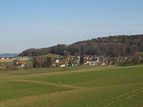
View of Büttikon |
|
| Location of the municipality | |
Büttikon ( Swiss German : ˈpʏtikχə ) is a municipality in the Swiss canton of Aargau . It belongs to the Bremgarten district and is located on the western edge of the Bünztal .
geography

The village lies on an extensive plateau between two foothills of the Lindenberg . These are the Nässi ( 570 m above sea level ) in the east and the Bärholz ( 510 m above sea level ) in the north. The plain extends from south-east to north-west towards Villmergen and is drained by the Hinterbach, a tributary of the Bünz . To the northeast, the plain drops steeply to the Bünztal.
The area of the municipality is 282 hectares , of which 93 hectares are covered with forest and 33 hectares are built over. The highest point is at 570 meters on the Nässi, the lowest at 445 meters on the eastern slope of the Bärholz. Neighboring communities are Wohlen in the north, Waltenschwil in the east, Uezwil in the south, Sarmenstorf in the southwest and Villmergen in the west.
history
Traces of Roman settlement were discovered in the middle of the 19th century on the north-eastern edge of the village on the slope against the village of Büelisacher, which belongs to the municipality of Waltenschwil , which prove that the area was settled in Roman times . Putinchova was first mentioned in a document in 893 in an interest sled in the Fraumünster Abbey in Zurich . The place name comes from the Old High German Putinghofun and means "at the farms of the Poto clan". The form used today first appeared in 1394.
The castle of Büttikon, of which no remains have been preserved, was the ancestral seat of the Lords of Büttikon, an important ministerial family of the Habsburgs , in the Middle Ages . As early as the 13th century they moved to Wikon Castle near Zofingen , from where they ruled over large areas in the valleys of the Wigger and Suhre and in the Seetal . After the Battle of Sempach in 1386, they lost a lot of their influence. The last of the line died in 1558 with no offspring.
The village was initially under the rule of the Counts of Kyburg . After they died out in 1264, the Habsburgs became the new rulers. The tithe had to be delivered to Muri Monastery . In 1415 the Lucerne population conquered the villages of Büttikon, Hilfikon , Sarmenstorf , Uezwil and Villmergen . But in 1425 they had to return the area to the common property of the Confederates . Büttikon was now in the office of Villmergen of the free offices , a common rule . There was a brick factory in the 17th and 18th centuries, the products of which were also very popular in Zurich .
In March 1798, the French invaded Switzerland and proclaimed the Helvetic Republic . Büttikon and Hilfikon formed a community in the Sarmenstorf district of the short-lived canton of Baden . When the canton of Aargau was founded in 1803, Hilfikon was separated again. Büttikon remained dominated by agriculture well into the 20th century. The population stagnated at just over 300 until 1960. Then, however, increased construction activity began and the number of residents has more than doubled to this day.
Attractions
The Büttikon chapel dates from 1695. A previous building at the same location was first mentioned in 1366 and is said to have been the castle chapel of the Lords of Büttikon. In 1696 the consecration took place in honor of Saint John the Baptist, another consecration took place in 1768. The exterior of the chapel with its rectangular nave and polygonal choir looks simple, apart from the roof turret with its strongly constricted onion hood . The last renovation was made in 1955. The Kochhaus , built in 1791 with the steep , half-hipped roof and numerous decorations, is considered to be one of the best-preserved farmhouses of this time in Freiamt.
coat of arms
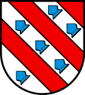
The blazon of the municipal coat of arms reads: "Divided diagonally five times by red and white, the white places occupied by six (2,3,1) blue iron hats." On the municipal seal from 1811, a black kettle with a ladle was seen in blue over a green Dreiberg. It was the coat of arms of the Koch family, which had it affixed to a donated stone cross in 1622. Later it was mistaken for the municipal coat of arms. In 1957 the historically justified coat of arms of the Lords of Büttikon was introduced, which has been documented since the 13th century.
population
The population developed as follows:
| year | 1798 | 1850 | 1900 | 1930 | 1950 | 1960 | 1970 | 1980 | 1990 | 2000 | 2010 |
| Residents | 188 | 273 | 254 | 322 | 316 | 314 | 434 | 500 | 618 | 656 | 919 |
On December 31, 2019, 975 people lived in Büttikon, the proportion of foreigners was 18.8%. In the 2015 census, 42.1% described themselves as Roman Catholic and 21.2% as Reformed ; 36.7% were non-denominational or of other faiths. In the 2000 census, 96.0% stated German as their main language.
Politics and law
The assembly of those entitled to vote, the municipal assembly , exercises legislative power. The executing authority is the five-member municipal council . He is elected by the people in the majority procedure, his term of office is four years. The parish council leads and represents the parish. To this end, it implements the resolutions of the municipal assembly and the tasks assigned to it by the canton. The Bremgarten District Court is primarily responsible for legal disputes . Büttikon belongs to the Friedensrichterkreis VI (Wohlen).
economy
According to the company structure statistics (STATENT) collected in 2015, there are around 210 jobs in Büttikon, 8% of them in agriculture, 34% in industry and 58% in the service sector. Most of the employed are commuters and work in the neighboring communities, mainly in Wohlen and Villmergen .
traffic
Büttikon is away from through traffic, but is accessible via several roads with the neighboring communities. The main road 25 between the A1 autobahn near Lenzburg and Zug runs about one kilometer north of the village. A post bus line connects Büttikon with Wohlen train station and with Uezwil .
education
The community has a kindergarten and a school house where primary school is taught. All upper levels of the compulsory elementary school ( Realschule , Secondary School , District School ) can be attended in neighboring Wohlen, as well as the closest grammar school, the Cantonal School Wohlen .
literature
- Anton Wohler: Büttikon. In: Historical Lexicon of Switzerland .
- Peter Felder: The art monuments of the canton of Aargau . Ed .: Society for Swiss Art History . Volume IV: Bremgarten district. Birkhäuser Verlag, Basel 1967, ISBN 3-906131-07-6 .
Web links
Individual evidence
- ↑ Cantonal population statistics 2019. Department of Finance and Resources, Statistics Aargau, March 30, 2020, accessed on April 2, 2019 .
- ↑ Cantonal population statistics 2019. Department of Finance and Resources, Statistics Aargau, March 30, 2020, accessed on April 2, 2019 .
- ↑ a b Beat Zehnder: The community names of the canton of Aargau . In: Historical Society of the Canton of Aargau (Ed.): Argovia . tape 100 . Verlag Sauerländer, Aarau 1991, ISBN 3-7941-3122-3 , p. 121-124 .
- ^ National map of Switzerland, sheets 1090 and 1110, Swisstopo.
- ↑ Standard area statistics - municipalities according to 4 main areas. Federal Statistical Office , November 26, 2018, accessed on May 14, 2019 .
- ↑ Jakob Heierli: The archaeological map of the canton of Aargau with general explanations and find register . In: Historical Society of the Canton of Aargau (Ed.): Argovia . tape 27 . Aarau 1898, p. 37 .
- ↑ Fields: The Art Monuments of the Canton of Aargau, Volume IV: Bremgarten District. Pp. 178-184.
- ^ Joseph Galliker, Marcel Giger: Municipal coat of arms of the Canton of Aargau . Lehrmittelverlag des Kantons Aargau, book 2004, ISBN 3-906738-07-8 , p. 137 .
- ↑ Population development in the municipalities of the Canton of Aargau since 1850. (Excel) In: Eidg. Volkszählung 2000. Statistics Aargau, 2001, archived from the original on October 8, 2018 ; accessed on May 14, 2019 .
- ↑ Resident population by religious affiliation, 2015. (Excel) In: Population and Households, Community Tables 2015. Statistics Aargau, accessed on May 14, 2019 .
- ↑ Swiss Federal Census 2000: Economic resident population by main language as well as by districts and municipalities. (Excel) Statistics Aargau, archived from the original on August 10, 2018 ; accessed on May 14, 2019 .
- ↑ circles of justice of the peace. Canton of Aargau, accessed on June 20, 2019 .
- ↑ Statistics of the corporate structure (STATENT). (Excel, 157 kB) Statistics Aargau, 2016, accessed on May 14, 2019 .


