
Daytime
| Daytime | |
|---|---|
 |
|
| State : |
|
| Canton : |
|
| District : | Bremgarten |
| BFS no. : | 4077 |
| Postal code : | 5522 |
| Coordinates : | 663 357 / 250728 |
| Height : | 384 m above sea level M. |
| Height range : | 346-522 m above sea level M. |
| Area : | 3.29 km² |
| Residents: | 1489 (December 31, 2019) |
| Population density : | 453 inhabitants per km² |
|
Proportion of foreigners : (residents without citizenship ) |
17.7% (December 31, 2019) |
| Website: | www.taegerig.ch |
 View of the village |
|
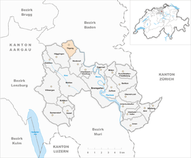
| Location of the municipality | |
  |
|
Tägerig ( Swiss German : ˈtæːɡəˌriɡ ) is a municipality in the Swiss canton of Aargau . It belongs to the Bremgarten district and is located in the Reuss Valley .
geography
The village is located on a terrace formed by the Reuss Glacier on the northeastern slope of the Wagenrain . This elongated ridge forms the natural border to the Bünztal . The Reuss flows about half a kilometer east of the village center in a north-westerly direction, whereby the river has formed an indentation around 20 meters deep in the otherwise flat valley floor due to erosion. The slopes of the Wagenrain are steep in the lower area and merge into the extensive Rötler plateau in the upper area. On this level, around one and a half kilometers south of Tägerig, lies at an altitude of 485 m above sea level. M. the hamlet of Büschikon.
The area of the municipality is 329 hectares , of which 135 hectares are covered with forest and 63 hectares are built over. The highest point is located half a kilometer west of the village at an altitude of 530 meters, the deepest at 348 meters on a small island in the Reuss, which was created by alluvial debris. Neighboring communities are Mellingen in the north, Stetten in the east, Niederwil in the southeast, Hägglingen in the south, and Wohlenschwil in the northwest.
history
Finds of several tools made of flint suggest a settlement during the Neolithic Age . The first mention of Tegeranc was in 1189, when Pope Clement III. placed the village under the protection of the Muri monastery with an umbrella letter . The place name comes from the Old High German Tegerwanc and means "large slope". The hamlet of Büschikon was first mentioned in 1315 when Ulrich Meyer von Rohrdorf, a citizen of the city of Mellingen , pledged his property to the convent in Gnadenthal .

As a fief of the Habsburgs , the village was owned by the von Rüssegg family in the 14th century. Around 1350 Zwing und Bann came to the Lords of Wohlen, 1409 to the Segesser von Brunegg and 1543 to the neighboring town of Mellingen . With the conquest of Aargau in 1415, sovereignty and blood jurisdiction changed to the Confederates , whereupon Tägerig belonged to the office of Niederwil in the Free Offices , a common rule . In 1627 a plague epidemic took a large part of the population. In the Peasants' War of 1653 and in the two Villmerger Wars of 1656 and 1712, the village was looted.
In March 1798 the French took Switzerland and proclaimed the Helvetic Republic . A municipality in the short-lived canton of Baden became Tägerig, and since 1803 it has belonged to the canton of Aargau. On March 17th, 1838, a fire destroyed almost the entire village, only a few houses remained. In addition to agriculture, the production of starch for textile processing has also played a major role since the 17th century . When this branch of industry lost its importance after 1850, many villagers became impoverished and had to emigrate, some to North America . Working from home for the straw industry was also unable to halt the population decline of around 40 percent. Electricity was introduced in 1920, and water was also introduced four years later. As one of the first municipalities in the canton, Tägerig fed the wastewater to a sewage treatment plant from 1955. In the 1960s, the population began to rise sharply due to the lively construction activity and good accessibility; this almost doubled within five decades.
Attractions


The chapel, built in 1665, suffered major damage in the village fire of 1838. Two years later, the Niederwil parish, to which Tägerig belonged until 1864, decided to build a new building. A late classical church building was built, which was inaugurated in June 1846. The ceiling and wall frescoes from the Lauretan litany inside are particularly worth seeing . To the west of the church are the rectory and the former school and parish hall, both built in 1865. The village is characterized by Biedermeier buildings from the mid-19th century. In the hamlet of Büschikon there is a small chapel from the early 17th century.
coat of arms
The blazon of the municipal coat of arms reads: "Two crossed white keys in blue, overlaid by a five-pointed white star." The coat of arms was introduced in 1915 and is said to be derived from the banner of the neighboring small town of Mellingen from 1512.
population
The population developed as follows:
| year | 1850 | 1900 | 1930 | 1950 | 1960 | 1970 | 1980 | 1990 | 2000 | 2010 |
| Residents | 990 | 606 | 755 | 726 | 775 | 815 | 859 | 1061 | 1193 | 1363 |
On December 31, 2019, 1489 people lived in Tägerig, the proportion of foreigners was 17.7%. In the 2015 census, 46.1% described themselves as Roman Catholic and 23.9% as Reformed ; 30.0% were non-denominational or belonged to other faiths. 92.6% said German as their main language in the 2000 census , 2.3% Albanian and 1.0% Serbo-Croatian .
Politics and law
The assembly of those entitled to vote, the municipal assembly , exercises legislative power. The executing authority is the five-member municipal council . He is elected by the people in the majority procedure, his term of office is four years. The parish council leads and represents the parish. To this end, it implements the resolutions of the municipal assembly and the tasks assigned to it by the canton. The Bremgarten District Court is primarily responsible for legal disputes . Tägerig belongs to the Friedensrichterkreis VI (Wohlen).
economy
According to the company structure statistics (STATENT) collected in 2015, there are around 200 jobs in Tägerig, 7% of them in agriculture, 13% in industry and 80% in the service sector. Most of the employed are commuters and work in Baden or in the Zurich agglomeration .
traffic
Tägerig is not far from Kantonsstrasse 296 from Mellingen to Bremgarten . It passes half a kilometer to the east, so that the village center is not affected by through traffic. Local roads lead to Wohlenschwil and via Büschikon to Hägglingen . The connection to public transport is provided by a post bus line from Baden via Mellingen to Bremgarten, and a night bus runs on almost the same route on weekends.
education
Tägerig owns a kindergarten and a school house in which primary school is taught. All upper levels ( Realschule , Secondary School and District School ) can be attended in Mellingen . The closest grammar schools are the Canton School Wohlen , the Canton School Baden and the Canton School Wettingen .
Personalities
- Jennifer Ann Gerber (* 1981), Miss Switzerland
- Paul Meierhans (1895–1976), journalist and politician
literature
- Peter Felder: The art monuments of the canton of Aargau . Ed .: Society for Swiss Art History . Volume IV: Bremgarten district. Birkhäuser Verlag, Basel 1967, ISBN 3-906131-07-6 .
- G. Meier: Written in Freiämter dialect. The “Ammelmehl-Fabrikation” in Tägeri. In: Schweizer Illustrierte , Vol. 12, 1908, pp. 105–111.
- Felix Müller: Day-long. In: Historical Lexicon of Switzerland .
Web links
Individual evidence
- ↑ Cantonal population statistics 2019. Department of Finance and Resources, Statistics Aargau, March 30, 2020, accessed on April 2, 2019 .
- ↑ Cantonal population statistics 2019. Department of Finance and Resources, Statistics Aargau, March 30, 2020, accessed on April 2, 2019 .
- ^ National map of Switzerland, sheet 1090, Swisstopo.
- ↑ Standard area statistics - municipalities according to 4 main areas. Federal Statistical Office , November 26, 2018, accessed on May 15, 2019 .
- ^ Beat Zehnder: The community names of the canton of Aargau . In: Historical Society of the Canton of Aargau (Ed.): Argovia . tape 100 . Verlag Sauerländer, Aarau 1991, ISBN 3-7941-3122-3 , p. 418-419 .
- ↑ Fields: The Art Monuments of the Canton of Aargau, Volume IV: Bremgarten District. Pp. 377-382.
- ^ Joseph Galliker, Marcel Giger: Municipal coat of arms of the Canton of Aargau . Lehrmittelverlag des Kantons Aargau, book 2004, ISBN 3-906738-07-8 , p. 288 .
- ↑ Population development in the municipalities of the Canton of Aargau since 1850. (Excel) In: Eidg. Volkszählung 2000. Statistics Aargau, 2001, archived from the original on October 8, 2018 ; accessed on May 15, 2019 .
- ↑ Resident population by religious affiliation, 2015. (Excel) In: Population and Households, Community Tables 2015. Statistics Aargau, accessed on May 15, 2019 .
- ↑ Swiss Federal Census 2000: Economic resident population by main language as well as by districts and municipalities. (Excel) Statistics Aargau, archived from the original on August 10, 2018 ; accessed on May 15, 2019 .
- ↑ circles of justice of the peace. Canton of Aargau, accessed on June 20, 2019 .
- ↑ Statistics of the corporate structure (STATENT). (Excel, 157 kB) Statistics Aargau, 2016, accessed on May 15, 2019 .
Arni | Berikon | Bremgarten | Büttikon | Dottikon | Eggenwil | Fischbach-Göslikon | Hagglingen | Islisberg | Jonen | Niederwil | Oberlunkhofen | Oberwil-Lieli | Rudolfstetten-Friedlisberg | Sarmenstorf | Daily | Uezwil | Unterlunkhofen | Villmergen | Widen | Wohlen | Zufikon
Former municipality: Anglikon | Arni-Islisberg | Hermetschwil squadrons | Hilfikon | Lieli | Nesselnbach
Canton of Aargau | Districts of the Canton of Aargau | Municipalities in the Canton of Aargau