
Villmergen
| Villmergen | |
|---|---|
 |
|
| State : |
|
| Canton : |
|
| District : | Bremgarten |
| BFS no. : | 4080 |
| Postal code : | 5612 Villmergen 5613 Hilfikon |
| UN / LOCODE : | CH VMG |
| Coordinates : | 660902 / 244382 |
| Height : | 430 m above sea level M. |
| Height range : | 406–712 m above sea level M. |
| Area : | 11.94 km² |
| Residents: | 7436 (December 31, 2019) |
| Population density : | 623 inhabitants per km² |
|
Proportion of foreigners : (residents without citizenship ) |
32.1% (December 31, 2019) |
| Website: | www.villmergen.ch |
 Villmergen |
|
| Location of the municipality | |
  |
|
Villmergen (the V spoken like an F; Swiss German : [ ˈfɪlˌmærɡə ]) is a municipality in the Swiss canton of Aargau . It belongs to the Bremgarten district and is located in the Bünztal in the south-east of the canton. The place is known as the scene of the decisive battles of the Villmerger Wars of 1656 and 1712. On January 1, 2010, the neighboring Hilfikon was incorporated.
geography

The village is located on the western edge of the Bünztal , at the foot of the Rietenberg. This wooded ridge is the northwest continuation of the Lindenberg . The northern part of the municipality lies in the Bünz plane, which had extensive marshland until the 1920s and was then drained. An extensive industrial zone extends northeast of the village. Around three kilometers north of the village, between Dintikon and Dottikon , there is a second settlement focus around the former Bally shoe factory , the Bally quarter. Hilfikon ( 479 m above sea level ) is located near the southern border of the municipality in the valley of the Erusbach. This takes on the Hinterbach in Villmergen, is called Holzbach in the following and flows into the Bünz near Dottikon.
The area of the municipality is 1194 hectares , of which 414 hectares are covered with forest and 290 hectares are built over. The highest point is at 712 m above sea level. M. on the Rietenberg, the deepest point at 408 m above sea level. M. at the Bünz. Neighboring communities are Dottikon in the north, Wohlen in the east, Büttikon in the southeast, Sarmenstorf in the south, Seengen and Egliswil in the west and Dintikon and Hendschiken in the northwest. The buildings in the east have grown together with those of the neighboring municipality of Wohlen.
history
In Roman times, a water pipe made of clay pipes ran through Villmergen, as a study in 1945 showed. Between 500 and 700 AD, an Alemannic settlement emerged in what is now the municipality . The village was first mentioned in a document as Vilmaringen in 1185 . The place name is derived from the Old High German Filmaringun and means "among the people of Vilmar", the current form of the name has been common since the 15th century.
In 1264 the Habsburgs took over rule from the Kyburgers . In 1415 the Lucerne people conquered the villages of Büttikon , Hilfikon , Sarmenstorf , Uezwil and Villmergen, but in 1425 they had to return the area to the common property of the Confederates . From then on, Villmergen was the capital of the office of the same name in the Free Offices , a common rule . In 1529 the village changed to the Reformed denomination, but after the Second Kappel War they had to return to Catholicism two years later.


On January 24, 1656, the First Battle of Villmergen took place in the Himmelrych area . The Catholic Lucerne and their allies triumphed against the Reformed Bernese . The village was looted and partially burned down. The religious conflict in the Confederation continued to smolder for decades, and so it came to the extremely bloody Second Battle of Villmergen on July 24, 1712 , in which the Bernese were victorious. More than 3,000 soldiers died on the Catholic side and around 1,000 on the Bernese side.
In March 1798 the French took Switzerland and proclaimed the Helvetic Republic . Villmergen was now a municipality in the Sarmenstorf district of the short-lived canton of Baden , and since 1803 it has belonged to the canton of Aargau. The first school building was built in 1840. On January 12, 1841, near Villmergen, there was a skirmish between the canton's troops and rebel free offices who revolted against the new constitution. Seven insurgents and two government soldiers died. This uprising was one of the causes of the Aargau monastery dispute .
From 1850 Villmergen developed from a stately farming village to a larger industrial village. This development accelerated after the opening of the Wohlen-Meisterschwanden Railway on December 18, 1916. After 1950 there was a renewed surge in development due to the settlement of numerous industrial companies and the number of inhabitants has almost tripled since then; the 5000 mark was exceeded in 1996. On May 31, 1997, the Wohlen-Meisterschwanden Railway was shut down. The section south of Villmergen has been converted into a cycle path , the section between Wohlen and Villmergen (up to the Rebenstrasse crossing) is still used sporadically for freight traffic.
On June 15, 2007, the municipal assemblies of Villmergen and Hilfikon approved the merger of the two municipalities. Referendums in both municipalities on November 25, 2007 confirmed the resolution, which was implemented on January 1, 2010.
Today the groundwater in Villmergen is contaminated with pesticides such as chlorothalonil . In order to lower the concentration, as much drinking water as possible is bought from Wohlen.
Attractions
The history of the Catholic parish church St. Peter and St. Paul goes back at least to the 12th century. The church, which dates back to the Middle Ages and was expanded several times, was at the top of the church hill and was demolished in 1862 due to lack of space. As a replacement, a new building in neo-Gothic style was built on a terrace below, based on plans by Wilhelm Keller, who was able to prevail against Joseph Caspar Jeuch and Ferdinand Stadler , among others . It was inaugurated in 1866 by Bishop Eugène Lachat . Due to its exposed location, this hall church towers over the rest of the village. Above the church stands the Chapel of the Holy Helper, built in 1697 as an ossuary . In the center of the village there are several houses from the 17th and 18th centuries. The landmark of Hilfikon is located on a hill above the village castle Hilfikon .

Catholic parish church of St. Peter and St. Paul

Catholic parish church of St. Peter and St. Paul

Memorial in memory of the battles of Villmergen
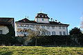
Hilfikon Castle
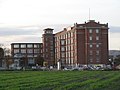
Former Bally shoe factory


coat of arms
The blazon of the municipal coat of arms reads: "In white, red rose with yellow clusters and green sepals." In Johannes Stumpf's work "Gemeiner praiseworthy Eydgno creates Stetten Landen vnd Völckeren Chronik wirdiger thaaten beſchreybung" from 1547/48 the red rose appears as the alleged coat of arms of the Lords of Villmergen, although it actually has a black tip in white. But at the latest with the community seal of 1811, the rose motif prevailed.
population
The population developed as follows:
| year | 1798 | 1850 | 1900 | 1930 | 1950 | 1960 | 1970 | 1980 | 1990 | 2000 | 2010 |
| Residents | 888 | 1594 | 1785 | 2707 | 2812 | 3232 | 4322 | 4042 | 4649 | 5079 | 5918 |
The following information relates to the sum of the municipalities of Villmergen and Hilfikon.
On December 31, 2019, 7,436 people lived in Villmergen, the proportion of foreigners was 32.1%. In the 2015 census, 48.4% described themselves as Roman Catholic and 14.1% as Reformed ; 37.5% were non-denominational or of other faiths. In the 2000 census, 86.5% stated German as their main language, 5.5% Italian , 1.3% Albanian , 1.2% Portuguese , 0.7% Turkish and 0.6% Serbo-Croatian .
Politics and law
The assembly of those entitled to vote, the municipal assembly , exercises legislative power. The executing authority is the five-member municipal council . He is elected by the people in the majority procedure, his term of office is four years. The parish council leads and represents the parish. To this end, it implements the resolutions of the municipal assembly and the tasks assigned to it by the canton. The Bremgarten District Court is primarily responsible for legal disputes . Villmergen belongs to the Friedensrichterkreis VI (Wohlen).
economy
According to the company structure statistics (STATENT) collected in 2015, there are around 3700 jobs in Villmergen, of which 2% are in agriculture, 45% in industry and 53% in the service sector. In addition to large international companies, Villmergen also has a large number of small and medium-sized companies. In the Allmend area, on the border with Wohlen, there is an extensive industrial area with large factories. The local companies benefit greatly from the favorable traffic situation and the low municipal tax rate. The most important company based in Villmergen is Behr Bircher Cellpack . There is also a mill that processes durum wheat and oats; the silo towers shape the village.
traffic
Villmergen is easily accessible. The village is about 7 km from the Lenzburg motorway junction next to Hauptstrasse 25 (Lenzburg− Zug ). The canton road 298, coming from Wohlen , leads through Villmergen into the Seetal , side roads provide connections to Büttikon and Dintikon . Public transport is ensured by three bus lines, all of which have their starting point at Wohlen station ; they lead to Meisterschwanden , Dintikon and the industrial area. The SBB train station Dottikon-Dintikon (which is located in the Villmerger municipality) is located about three kilometers north of the actual village. On weekends, night buses run from Lenzburg via Villmergen and Wohlen to Dottikon and from Dietikon via Villmergen to Sarmenstorf .
education

Villmergen has a kindergarten with several departments as well as three schoolhouses in which the primary school , the secondary school and the secondary school are taught. The district school can be attended in Wohlen , as can the canton school in Wohlen (grammar school). The children of the Bally area also go to school in Villmergen.
Personalities
- Pius Fischbach (* 1948), football player
- Robert Stäger (1902–1981), dialect poet
- Paul Steinmann (* 1956), playwright and director
- Joachim Wey (1774–1844), councilor and judge
- Susanne Wille (* 1974), journalist and television presenter, grew up in Villmergen
literature
- Raoul Richner: Villmergen. In: Historical Lexicon of Switzerland .
- Peter Felder: The art monuments of the canton of Aargau . Ed .: Society for Swiss Art History . Volume IV (Bremgarten district). Birkhäuser Verlag, Basel 1967, ISBN 3-906131-07-6 , p. 387-404 .
Web links
Individual evidence
- ↑ Cantonal population statistics 2019. Department of Finance and Resources, Statistics Aargau, March 30, 2020, accessed on April 2, 2019 .
- ↑ Cantonal population statistics 2019. Department of Finance and Resources, Statistics Aargau, March 30, 2020, accessed on April 2, 2019 .
- ^ National map of Switzerland, sheet 1090, Swisstopo.
- ↑ Standard area statistics - municipalities according to 4 main areas. Federal Statistical Office , November 26, 2018, accessed on May 15, 2019 .
- ^ Martin Hartmann, Hans Weber: The Romans in Aargau . Verlag Sauerländer, Aarau 1985, ISBN 3-7941-2539-8 , p. 205 .
- ^ Beat Zehnder: The community names of the canton of Aargau . In: Historical Society of the Canton of Aargau (Ed.): Argovia . tape 100 . Verlag Sauerländer, Aarau 1991, ISBN 3-7941-3122-3 , p. 449-450 .
- ↑ Hans Rudolf Fuhrer, Military Academy of the ETH Zurich: Villmerger Wars 1656/1712 . In: Military history at your fingertips . tape 19 . Federal Office for Buildings and Logistics , Bern 2005.
- ↑ Ongoing trend towards parish mergers . Neue Zürcher Zeitung , November 26, 2007, accessed on December 31, 2009 .
- ↑ Andrea Weibel: Too many toxins: Villmergen has to buy water from Wohlen. In: aargauerzeitung.ch . September 6, 2019, accessed September 6, 2019 .
- ↑ Fields: The Art Monuments of the Canton of Aargau, Volume IV: Bremgarten District. Pp. 387-404.
- ^ Joseph Galliker, Marcel Giger: Municipal coat of arms of the canton of Aargau . Lehrmittelverlag des Kantons Aargau, book 2004, ISBN 3-906738-07-8 , p. 306 .
- ↑ Population development in the municipalities of the Canton of Aargau since 1850. (Excel) In: Eidg. Volkszählung 2000. Statistics Aargau, 2001, archived from the original on October 8, 2018 ; accessed on May 15, 2019 .
- ↑ Resident population by religious affiliation, 2015. (Excel) In: Population and Households, Community Tables 2015. Statistics Aargau, accessed on May 15, 2019 .
- ↑ Swiss Federal Census 2000: Economic resident population by main language as well as by districts and municipalities. (Excel) Statistics Aargau, archived from the original on August 10, 2018 ; accessed on May 15, 2019 .
- ↑ circles of justice of the peace. Canton of Aargau, accessed on June 20, 2019 .
- ↑ Statistics of the corporate structure (STATENT). (Excel, 157 kB) Statistics Aargau, 2016, accessed on May 15, 2019 .
Arni | Berikon | Bremgarten | Büttikon | Dottikon | Eggenwil | Fischbach-Göslikon | Hagglingen | Islisberg | Jonen | Niederwil | Oberlunkhofen | Oberwil-Lieli | Rudolfstetten-Friedlisberg | Sarmenstorf | Daily | Uezwil | Unterlunkhofen | Villmergen | Widen | Wohlen | Zufikon
Former municipality: Anglikon | Arni-Islisberg | Hermetschwil squadrons | Hilfikon | Lieli | Nesselnbach
Canton of Aargau | Districts of the Canton of Aargau | Municipalities in the Canton of Aargau