
Zufikon
| Zufikon | |
|---|---|
 |
|
| State : |
|
| Canton : |
|
| District : | Bremgarten |
| BFS no. : | 4083 |
| Postal code : | 5621 |
| Coordinates : | 669 582 / 244303 |
| Height : | 402 m above sea level M. |
| Height range : | 368-543 m above sea level M. |
| Area : | 4.81 km² |
| Residents: | 4501 (December 31, 2019) |
| Population density : | 936 inhabitants per km² |
|
Proportion of foreigners : (residents without citizenship ) |
20.0% (December 31, 2019) |
| Website: | www.zufikon.ch |
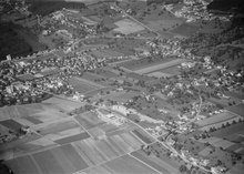
 Village with church |
|
| Location of the municipality | |
  |
|
Zufikon ( Swiss German : ˈtsufikχə ) is a municipality in the Swiss canton of Aargau . It belongs to the Bremgarten district and is located immediately east of the district capital Bremgarten in the Reuss Valley .
geography
The historic village center consists of the upper village and the lower village about 300 meters away. Both are at a height of around 405 meters on the edge of the plain east of the Reuss . The western boundary of the municipality essentially follows the river, with the exception of the Zopfhau, where it runs across this peninsula. The forested hill Buechholderen ( 420 m above sea level ) rises up on the river in the very south, and the Nüeschwald hill ( 435 m above sea level ) in the southeast . To the east the terrain rises steeply to the plateau of the Holzbirrliberg , to the northeast to the Mutschellenpass ( 551 m above sea level ). The southwest slope of the Mutschellen was built over practically without gaps with residential houses in the second half of the 20th century. For this reason, Zufikon has not only grown together with Bremgarten , but also with Widen and Berikon .
The area of the municipality is 481 hectares , of which 126 hectares are covered with forest and 120 hectares are built over. The highest point is at an altitude of 542 m above sea level. M. below the Mutschellen, the deepest at 373 m above sea level. M. on the Reuss. Neighboring communities are Widen in the north, Berikon in the east, Oberwil-Lieli in the southeast, Unterlunkhofen in the south and Bremgarten in the west.
history
A single find indicates a settlement in the Bronze Age . Zuffinchofa was first mentioned in a document in 1150. The place name comes from the Old High German Uffinghofun and means "at the farms of the Uffo clan". After 1200, Zufikon came under the rule of the Counts of Habsburg-Laufenburg , a side line of the Habsburgs . The bailiwick came into the possession of the knights of Schönenwerd in 1318, who were followed by the lords of Seengen. Both were servants of the Habsburgs and exercised minor jurisdiction , while blood jurisdiction was reserved for the Habsburgs.
The most important landowners in the Middle Ages were the monasteries of Sankt Blasien , Frauenthal , Hermetschwil and Muri . In the 14th and 15th centuries Bremgarten was able to acquire more and more goods and basic rights, either directly or through townspeople like the Lords of Seengen. In 1415 the confederates conquered Aargau. While the part of the village north of the church tower was part of the Rohrdorf office of the County of Baden and was administered jointly by the Confederates, the southern part belonged to the cellar office and was therefore under the sole rule of the city of Zurich .
In 1450 Bremgarten acquired the lower jurisdiction over Zufikon as well as the church rate and the tithe of grain and wine. In 1516 the Emauskapelle received special privileges as a place of pilgrimage by papal resolution. The population converted to the Protestant denomination in 1529, but was re-Catholicized in 1531 after the Second Kappel War . In March 1798 the French took Switzerland and proclaimed the Helvetic Republic . The reunited parts of the village formed a municipality in the short-lived canton of Baden , and since 1803 Zufikon has belonged to the canton of Aargau.
1893/94, the Zurich company built Escher-Wyss at the Reuss power plant Bremgarten-Zufikon , as the first three-phase - hydroelectric power plant in Europe. It was demolished in 1975 and replaced by a more modern system. On May 1, 1902, with the opening of the Bremgarten-Dietikon-Bahn , Zufikon was connected to the railway network. From around 1960 a building boom set in, during which the entire southwest slope of Mutschellen, which was once planted with vines, was built over. The population increased almost fivefold within fifty years.
Attractions


The history of the Catholic parish church of St. Martin goes back at least to 1275, the year it was first mentioned in a document. The dilapidated building was replaced in 1865/68 by a neo-Romanesque hall church designed by canton master builder Carl Rothpletz . The church tower from the Middle Ages remained. The interior of the building is late classicist .
The Emaus chapel is located near the river bank by the power station. It was built between 1552 and 1556, on the site of an earlier hermitage. Three painted baroque picture cycles are particularly worth seeing. They represent Antonius the Great , Antonius of Padua and Niklaus von Flüe .
coat of arms
The blazon of the municipal coat of arms reads: "Under a red shield head in white and black post, next to two overturned blue keys with turned beards." Since 1915 there was an unofficial coat of arms, which showed a red border stone in white. In 1949, however, the municipal council did not want to symbolize what divides, but what connects. For this reason, the symbols of the county of Baden (shield head with stake) and the basement office (key) were combined in one coat of arms.
population
The population developed as follows:
| year | 1850 | 1900 | 1930 | 1950 | 1960 | 1970 | 1980 | 1990 | 2000 | 2010 |
| Residents | 589 | 604 | 731 | 774 | 925 | 1405 | 2613 | 3516 | 3488 | 4140 |
On December 31, 2019, 4501 people lived in Zufikon, the proportion of foreigners was 20%. In the 2015 census, 39.9% described themselves as Roman Catholic and 19.7% as Reformed ; 40.4% were non-denominational or of other faiths. In the 2000 census, 90.1% stated German as their main language, 2.2% Italian , 1.5% Turkish , 1.1% Serbo-Croatian and 0.9% Albanian .
Politics and law
The assembly of those entitled to vote, the municipal assembly , exercises legislative power. The executing authority is the five-member municipal council . He is elected by the people in the majority procedure, his term of office is four years. The parish council leads and represents the parish. To this end, it implements the resolutions of the municipal assembly and the tasks assigned to it by the canton. The Bremgarten District Court is primarily responsible for legal disputes . Zufikon belongs to the Friedensrichterkreis VII (Bremgarten).
economy
According to the company structure statistics (STATENT) collected in 2015, there are around 1,100 jobs in Zufikon, of which 2% are in agriculture, 26% in industry and 72% in the service sector. All of the approximately 150 companies are small and medium-sized companies . Most of the employed are commuters and work in neighboring Bremgarten or in the city of Zurich and its agglomeration.
traffic
At the northern edge of Zufikon, Hauptstrasse 1 runs over Mutschellen and Kantonsstrasse 263 in the direction of Birmensdorf , where there is a connection to the A4 . The canton road 262 leads in the direction of Affoltern am Albis . The northern part of the village on the slope is accessed by the Bremgarten-Dietikon-Bahn from Dietikon to Wohlen ; The Zufikon, Hammergut and Belvédère stops are in the municipality. The flat part of the village at the foot of the hill is close to the Bremgarten train station and is also served by the Bremgarten– Jonen post bus line and the Zufikon local bus. On weekends there is a night bus from Dietikon via Wohlen to Sarmenstorf .
education
The community has five kindergartens and three school houses in which the primary school , the junior high school and the secondary school are taught. The district school can be attended in the neighboring Bremgarten. The closest grammar school is the Cantonal School in Wohlen .
literature
- Anton Wohler: Zufikon. In: Historical Lexicon of Switzerland .
- Peter Felder: The art monuments of the canton of Aargau . Ed .: Society for Swiss Art History . Volume IV: Bremgarten district. Birkhäuser Verlag, Basel 1967, ISBN 3-906131-07-6 .
- Hans Bürgisser: Chronicle of the community of Zufikon . Ed .: local citizen community Zufikon. Zufikon 1986, DNB 941921875 .
Web links
Individual evidence
- ↑ Cantonal population statistics 2019. Department of Finance and Resources, Statistics Aargau, March 30, 2020, accessed on April 2, 2019 .
- ↑ Cantonal population statistics 2019. Department of Finance and Resources, Statistics Aargau, March 30, 2020, accessed on April 2, 2019 .
- ↑ a b Beat Zehnder: The community names of the canton of Aargau . In: Historical Society of the Canton of Aargau (Ed.): Argovia . tape 100 . Verlag Sauerländer, Aarau 1991, ISBN 3-7941-3122-3 , p. 489-490 .
- ^ National map of Switzerland, sheet 1090, Swisstopo.
- ↑ Standard area statistics - municipalities according to 4 main areas. Federal Statistical Office , November 26, 2018, accessed on May 15, 2019 .
- ↑ a b Fields: The Art Monuments of the Canton of Aargau, Volume IV: Bremgarten District. Pp. 431-442.
- ^ Joseph Galliker, Marcel Giger: Municipal coat of arms of the Canton of Aargau . Lehrmittelverlag des Kantons Aargau, book 2004, ISBN 3-906738-07-8 , p. 328 .
- ↑ Population development in the municipalities of the Canton of Aargau since 1850. (Excel) In: Eidg. Volkszählung 2000. Statistics Aargau, 2001, archived from the original on October 8, 2018 ; accessed on May 15, 2019 .
- ↑ Resident population by religious affiliation, 2015. (Excel) In: Population and Households, Community Tables 2015. Statistics Aargau, accessed on May 15, 2019 .
- ↑ Swiss Federal Census 2000: Economic resident population by main language as well as by districts and municipalities. (Excel) Statistics Aargau, archived from the original on August 10, 2018 ; accessed on May 15, 2019 .
- ↑ circles of justice of the peace. Canton of Aargau, accessed on June 20, 2019 .
- ↑ Statistics of the corporate structure (STATENT). (Excel, 157 kB) Statistics Aargau, 2016, accessed on May 15, 2019 .
Arni | Berikon | Bremgarten | Büttikon | Dottikon | Eggenwil | Fischbach-Göslikon | Hagglingen | Islisberg | Jonen | Niederwil | Oberlunkhofen | Oberwil-Lieli | Rudolfstetten-Friedlisberg | Sarmenstorf | Daily | Uezwil | Unterlunkhofen | Villmergen | Widen | Wohlen | Zufikon
Former municipality: Anglikon | Arni-Islisberg | Hermetschwil squadrons | Hilfikon | Lieli | Nesselnbach
Canton of Aargau | Districts of the Canton of Aargau | Municipalities in the Canton of Aargau