Sarmenstorf
| Sarmenstorf | |
|---|---|
| State : |
|
| Canton : |
|
| District : | Bremgarten |
| BFS no. : | 4076 |
| Postal code : | 5614 |
| Coordinates : | 661 397 / 240249 |
| Height : | 539 m above sea level M. |
| Height range : | 497–707 m above sea level M. |
| Area : | 8.30 km² |
| Residents: | 2932 (December 31, 2019) |
| Population density : | 353 inhabitants per km² |
|
Proportion of foreigners : (residents without citizenship ) |
15.0% (December 31, 2019) |
| Website: | www.sarmenstorf.ch |
|
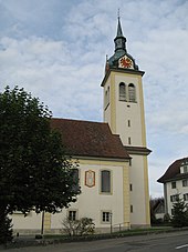
View from the southeast |
|
| Location of the municipality | |
Sarmenstorf ( Swiss German : ˈsɑːrmiʃˌdɔrf ) is a municipality in the Swiss canton of Aargau in the lower Freiamt . It belongs to the Bremgarten district .
geography
The village lies on a flat saddle between the Bünztal and the Seetal , around two kilometers east of Lake Hallwil . It is located between the foothills of Lindenberg in the southeast and Rietenberg in the northwest. The municipality is drained to the north by the Erusbach, which flows into the Bünz near Dottikon . There is no actual village center. The community consists of the districts of Chilenwinkel, Fröschenwinkel, Oberdorf and Vorstatt, which have grown together over the past few decades. While Fröschenwinkel and Vorstatt are on the plateau, the Oberdorf and Chilenwinkel are slightly elevated on a ridge. This climbs gently in a south-easterly direction to the Niesenberg, a branch of the Lindenberg.
The area of the municipality is 830 hectares , of which 243 hectares are covered with forest and 112 hectares are built over. The highest point is at 702 m above sea level. M. on Niesenberg, the deepest at 504 m above sea level. M. am Erusbach. Neighboring communities are Villmergen in the north, Büttikon in the northeast, Uezwil in the east, Kallern in the southeast, Bettwil and Fahrwangen in the south and Meisterschwanden and Seengen in the west.
history
Significant finds indicate that the Sarmenstorf municipality was already settled during the Neolithic Age. In 1926/27 several burial mounds from around 2200 BC were found in the Sarmenstorf necropolis in Zigiholz . Examined. These tombs were used during the Bronze Age around 1400 BC. BC was used again for burials. To the east of the village, the Roman villa Murimooshau from Roman times was excavated and examined in 1927 .
The settlement by the Alemanni is documented by a burial ground in the Büel area . Sarmarsdorf was first mentioned in a document in 1173. The place name comes from the Old High German Saramannesthorf and means "village of Saraman". The village was owned by the Counts of Lenzburg until 1173 and then by Beromünster Abbey . Other important landowners at that time were the monasteries of Einsiedeln , Sankt Blasien and Säckingen . The Habsburgs took over sovereignty in 1306 and with it the high level of jurisdiction .
In 1415 the Lucerne population conquered the villages of Büttikon , Hilfikon , Sarmenstorf, Uezwil and Villmergen . But in 1425 they had to return the area to the common property of the Confederates . Sarmenstorf was now the capital of the office of the same name in the Free Offices , a common rule . The lower jurisdiction over the Sarmenstorf Bailiwick changed hands several times: from the Lords of Küssnacht to the Lords of Eschenz , the Hermetschwil Monastery , the Lords of Hilfikon and the von Roll family from Solothurn .
In March 1798 the French took Switzerland and proclaimed the Helvetic Republic . Sarmenstorf was the district capital in the short-lived canton of Baden for five years . The community has belonged to the canton of Aargau since 1803. In the 19th century, industry slowly found its way, so in 1835 the Freiamt's first book printing plant was opened in Sarmenstorf. In the same year Elise Ruepp opened a private subsidiary that also trained teachers. On December 18, 1916, the village was connected to the railway network when the Wohlen-Meisterschwanden-Bahn started operating. However, the railway line had to be shut down on May 31, 1997. The population stagnated until around 1980, but has since increased by more than half.
Attractions
The history of the Catholic parish church Heiligkreuz goes back to the early Middle Ages. In 1986 archaeological excavations unearthed the remains of a Carolingian church building from around 800. A new building erected in 1622 partially used its foundations. The current building was built between 1778 and 1786. An ossuary chapel was built on the north side of the parish church in 1780 , the neighboring rectory dates from 1744/45.
The interior of the parish church is mostly in the Rococo style that was prevalent at the time . The main focus is on an epitaph flanked by two figures . The figures represent two Anglo-Saxon pilgrims who, according to a legend , were murdered in the nearby hamlet of Büelisacher ( Waltenschwil municipality ) and who then wandered to Sarmenstorf with their severed heads. Their bones are buried in the sacrificial altar.
The Wendelinskapelle, built in 1650, stands on the north-eastern edge of the village on the road to Büttikon . It was built around a boulder , which is interpreted as a pre-Christian sacrificial site and contains the bones of the catacomb saint Firmanus. Several houses from the early 19th century have been preserved in the village center.
The Heidenhübelstein in the southeast of the village is one of the largest boulders in the canton.
coat of arms
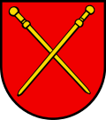
The blazon of the municipal coat of arms reads: "In red two crossed yellow pilgrim sticks." The pilgrim's wands first appeared in 1734 on a document from the Muri monastery . They remind of the legend of the two murdered Anglo-Saxon pilgrims. Until 1905 the bars appeared in a blue field above a green three-mountain , since then they have been floating freely in red.
population
The population developed as follows:
| year | 1850 | 1900 | 1930 | 1950 | 1960 | 1970 | 1980 | 1990 | 2000 | 2010 |
| Residents | 1240 | 1212 | 1338 | 1398 | 1379 | 1491 | 1431 | 1708 | 2146 | 2480 |
On December 31, 2019, 2932 people lived in Sarmenstorf, the proportion of foreigners was 15%. In the 2015 census, 51.3% described themselves as Roman Catholic and 20.3% as Reformed ; 28.4% were non-denominational or of other faiths. In the 2000 census, 93.8% stated German as their main language, 2.2% Italian , 0.7% each Spanish and Serbo-Croatian and 0.6% each Albanian and English .
Politics and law
The assembly of those entitled to vote, the municipal assembly , exercises legislative power. The executing authority is the five-member municipal council . He is elected by the people in the majority procedure, his term of office is four years. The parish council leads and represents the parish. To this end, it implements the resolutions of the municipal assembly and the tasks assigned to it by the canton. The Bremgarten District Court is primarily responsible for legal disputes . Sarmenstorf belongs to the Friedensrichterkreis VI (Wohlen).
economy
According to the corporate structure statistics (STATENT) collected in 2015, there are around 680 jobs in Sarmenstorf, 8% of them in agriculture, 34% in industry and 58% in the service sector. Many people in employment are commuters and work in the surrounding communities, especially in Villmergen and Wohlen .
traffic
Sarmenstorf is located on the busy Kantonsstrasse 298 between Wohlen and the Seetal . Side roads lead to Seengen and Büttikon . The closest motorway connection ( A1 ) is around 15 minutes' drive away at Lenzburg . From the train station Wohlen to Meisterschwanden a bus leaves the company bus Limmat , the 1997 Wohlen-Meisterschwanden railway has replaced. The former railway line was converted into a cycle path . On weekends, night buses run from Dietikon via Wohlen to Sarmenstorf and from Lenzburg via Meisterschwanden to Sarmenstorf.
education
The community has three kindergartens and a school house in which the primary school is taught. The secondary school and the Realschule are run together with the Meisterschwanden community , the district school can be attended in Fahrwangen . The closest grammar school is the Cantonal School in Wohlen .
Personalities
- Augustin Keller (1805–1883), politician and co-founder of the Christian Catholic Church
- Kaspar Koch (1742–1805), priest and revolutionary
- Elise Ruepp (1790–1873), pioneer in the education of women and teachers
- Xaver Stalder (1868–1936), Councilor
- Alois Vock (1785–1857), dean of the cathedral diocese of Basel, educator and historian
literature
- Anton Wohler: Sarmenstorf. In: Historical Lexicon of Switzerland .
- Peter Felder: The art monuments of the canton of Aargau . Ed .: Society for Swiss Art History . Volume IV: Bremgarten district. Birkhäuser Verlag, Basel 1967, ISBN 3-906131-07-6 .
Web links
Individual evidence
- ↑ Cantonal population statistics 2019. Department of Finance and Resources, Statistics Aargau, March 30, 2020, accessed on April 2, 2019 .
- ↑ Cantonal population statistics 2019. Department of Finance and Resources, Statistics Aargau, March 30, 2020, accessed on April 2, 2019 .
- ↑ a b Beat Zehnder: The community names of the canton of Aargau . In: Historical Society of the Canton of Aargau (Ed.): Argovia . tape 100 . Verlag Sauerländer, Aarau 1991, ISBN 3-7941-3122-3 , p. 211-213 .
- ^ National map of Switzerland, sheet 1110, Swisstopo.
- ↑ Standard area statistics - municipalities according to 4 main areas. Federal Statistical Office , November 26, 2018, accessed on May 15, 2019 .
- ^ The Roman estate Murimooshau. (PDF) Cantonal Archeology Aargau , archived from the original on March 7, 2011 ; Retrieved January 16, 2010 .
- ↑ History. Sarmenstorf municipality, accessed on June 24, 2009 .
- ↑ a b Peter Felder: The art monuments of the canton Aargau . Ed .: Society for Swiss Art History. Volume IV: Bremgarten district. Birkhäuser Verlag, Basel 1967, ISBN 3-906131-07-6 , p. 351-376 .
- ↑ Anglo-Saxons and the name of the village. Sarmenstorf municipality, accessed on June 24, 2009 .
- ^ Joseph Galliker, Marcel Giger: Municipal coat of arms of the Canton of Aargau . Lehrmittelverlag des Kantons Aargau, book 2004, ISBN 3-906738-07-8 , p. 263 .
- ↑ Population development in the municipalities of the Canton of Aargau since 1850. (Excel) In: Eidg. Volkszählung 2000. Statistics Aargau, 2001, archived from the original on October 8, 2018 ; accessed on May 15, 2019 .
- ↑ Resident population by religious affiliation, 2015. (Excel) In: Population and Households, Community Tables 2015. Statistics Aargau, accessed on May 15, 2019 .
- ↑ Swiss Federal Census 2000: Economic resident population by main language as well as by districts and municipalities. (Excel) Statistics Aargau, archived from the original on August 10, 2018 ; accessed on May 15, 2019 .
- ↑ circles of justice of the peace. Canton of Aargau, accessed on June 20, 2019 .
- ↑ Statistics of the corporate structure (STATENT). (Excel, 157 kB) Statistics Aargau, 2016, accessed on May 15, 2019 .


