Hagglingen
| Hagglingen | |
|---|---|
| State : |
|
| Canton : |
|
| District : | Bremgarten |
| BFS no. : | 4068 |
| Postal code : | 5607 |
| Coordinates : | 661 432 / 249020 |
| Height : | 473 m above sea level M. |
| Height range : | 439-590 m above sea level M. |
| Area : | 7.75 km² |
| Residents: | 2441 (December 31, 2019) |
| Population density : | 315 inhabitants per km² |
|
Proportion of foreigners : (residents without citizenship ) |
14.5% (December 31, 2019) |
| Website: | www.haegglingen.ch |
|
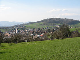
View from the east |
|
| Location of the municipality | |
Hägglingen ( Swiss German : ˈhækliɡə ) is a municipality in the Swiss canton of Aargau . It is located in the western part of the Bremgarten district on the edge of the Bünztal .
geography
The village is also known as the "Seven Hill Village" because it lies on the Rötler plateau, which is bordered by numerous hills of the Wagenrain chain. About one kilometer east of the village is the watershed between the Bünztal and Reuss valley . The Maiengrün, at 589 m above sea level. M. the highest of these hills, lies in the north-west. The hamlet of Igelweid ( 508 m above sea level ) lies around one and a half kilometers north of the village , in a valley between the Maiengrün and the Ringlisberg ( 551 m above sea level ). The hamlet of Rüti ( 510 m above sea level ) is just over two kilometers to the southeast .
The area of the municipality is 775 hectares , of which 254 hectares are forested and 86 hectares are built over. The highest point is at 589 meters on the Maiengrün hill, the lowest at 445 meters on the western boundary of the municipality. Neighboring communities are Mägenwil and Wohlenschwil in the north, Tägerig in the northeast, Niederwil in the east, Wohlen in the south, Dottikon in the west and Othmarsingen in the northwest.
history
The colonization of the plateau took place for the first time by the Romans in connection with the construction of the legionary camp Vindonissa . The legionaries exploited a quarry in the forest between Mägenwil and Hägglingen. The Alemanni settled in around the 6th century . Hekelingen was first mentioned in a document in 1036 . The place name comes from the Old High German Haccilingun and means "among the people of Haccilo". At that time, Count Ulrich von Lenzburg donated the church and the Meierhof to Beromünster Abbey , but still retained the lordly rights.
After the Lenzburger died out , the Counts of Kyburg took over the rule in 1173. These in turn died out in 1264 and the Habsburgs took over their inheritance. The lower courts was the Hallwyler awarded, while the Habsburgs, the high jurisdiction retained. In 1415 the Swiss conquered the Aargau and Hägglingen formed an office in the free offices , a common rule . In 1529 the population converted to the Reformation , but had to return to the Catholic denomination two years later, after the Second Kappel War . Between 1611 and 1613, a quarter of the population died in plague epidemics .
Marching Bernese troops looted the village on January 24, 1656 before the first battle of Villmergen , desecrated the church and burned numerous houses. After the second Villmerger War of 1712, the Catholic places lost their influence in the lower free offices and Hägglingen was administered from Zurich , Bern and Glarus . In March 1798 the French conquered Switzerland and declared the Helvetic Republic . On April 26, there was a battle near Hägglingen between French and federal troops on the Emmetfeld , which is reminiscent of a wayside cross between Hägglingen and Rüti. Until October 1801 there were repeated passages and billeting of French troops. Mediation followed the Helvetic in 1803 , which prevented the old dream of joining the Freiamt to Zug and incorporated the short-lived canton of Baden into the canton of Aargau.
From 1805 to 1815 the village bought itself free from the tithe . Until 1867 Hägglingen belonged to the parish of Dottikon . In 1823 the hamlet of Rüti was incorporated, which had previously been a Steckhof and an exclave of the Hermetschwil Office . In 1850 Hägglingen was the third largest municipality in the district. After several waves of emigration, the number of inhabitants decreased and only reached the old level a century later. Since then, the number of inhabitants has only increased slightly. Hägglingen did not go through the same stormy development as numerous other villages in the Bremgarten district.
Attractions
The Catholic parish church consecrated to the Archangel Michael is one of the oldest in Freiamt and was built at the beginning of the 11th century at the latest. A new building took place between 1457 and 1466, whereby the lower part of the tower has been preserved to this day. In 1951 the foundations of the previous Romanesque church and late Gothic frescoes came to light in the tower . The choir and a little more than half of the current nave were built between 1739 and 1742. The nave was demolished and the opening to this on the west side of the tower choir was walled up, and the tower choir itself was converted into a sacristy . Franz Xaver Wiederkehr from Mellingen , who was mayor at the time, was in charge of the new building for the choir and ship . Around 1750 the bell tower was raised. The ship was lengthened by 10 meters between 1831 and 1832, while the western sign was removed.
The rectory dates from 1744 and is a typical Freiämter Dixhuitième building. It is three-story and has a square floor plan. The eaves facing the church forms the representative side of the building. The wall openings are arranged symmetrically in three axes, above the central entrance portal is the oval heraldic relief with the coat of arms of Beromünster and the construction date 1744.
On the Maiengrün stands the 35 meter high Maiengrünturm , with a view of the Black Forest and the Alps .
coat of arms
The blazon of the municipal coat of arms reads: "Yellow hackle slanted in blue with black nails." The Hechel , a device for processing hemp, goes back to a folk etymological misinterpretation of the place name and appeared for the first time in 1547/48 in the illustrated chronicle by Johannes Stumpf . In Hans Conrad Gygers card from the year 1667, the same coat of arms is included. A hemp flower was later added to the hackle. The municipal council and the local citizens' commission decided in 1965 to return to the heraldic correct coat of arms. The Aargau State Archives stated: "The coat of arms in the present antique depiction is one of the canton's best heraldic municipal coats of arms, and the municipality can be proud of its shape and age." The nails were graphically simplified in 2002.
population
The population developed as follows:
| year | 1850 | 1900 | 1930 | 1950 | 1960 | 1970 | 1980 | 1990 | 2000 | 2010 |
| Residents | 1535 | 1415 | 1466 | 1514 | 1564 | 1711 | 1672 | 1846 | 1990 | 2281 |
On December 31, 2019, 2,441 people lived in Hägglingen, the proportion of foreigners was 14.5%. In the 2015 census, 46.5% described themselves as Roman Catholic and 21.7% as Reformed ; 31.8% were non-denominational or of other faiths. 92.4% stated German as their main language in the census , 1.6% each Albanian , Italian and Serbo-Croatian and 1.0% Turkish .
Politics and law
The assembly of those entitled to vote, the municipal assembly , exercises legislative power. The executing authority is the five-member municipal council . He is elected by the people in the majority procedure, his term of office is four years. The parish council leads and represents the parish. To this end, it implements the resolutions of the municipal assembly and the tasks assigned to it by the canton. The Bremgarten District Court is primarily responsible for legal disputes . Hägglingen belongs to the judges of peace VI (Wohlen).
economy
According to the company structure statistics (STATENT) collected in 2015, there are around 850 jobs in Hägglingen, of which 12% are in agriculture, 54% in industry and 34% in the service sector. The plastics industry is particularly important. Most of the employed are commuters and work in Dottikon , Lenzburg , Villmergen or Wohlen .
traffic
Hägglingen is not burdened by through traffic as there is no main road through the village. The Mägenwil motorway junction is only a few minutes away by car. There are two post bus lines to Wohlen station , one via Anglikon , the other via Villmergen .
education
In Hägglingen there are two kindergartens and a school house in which the primary school is taught. All types of upper school ( Realschule , Secondary School and District School ) could be attended in neighboring Dottikon . The closest grammar school is the Cantonal School in Wohlen .
Personalities
- Schmid siblings , who celebrated great success throughout Europe and later in the USA in the 1940s and 1950s with popular songs by their composer Artur Beul .
- Theo Fischer (* 1937), National Councilor
- Johann Huber (1812–1879), provost in Zurzach
- Ariane Pejkovic (* 1986), handball player
- Stefan Richner (* 1974), racing cyclist
- Thomas Schmid (* 1950), journalist
- Pierre Stutz (* 1953), theologian
literature
- Anton Wohler: Hägglingen. In: Historical Lexicon of Switzerland .
- Peter Felder: The art monuments of the canton of Aargau . Ed .: Society for Swiss Art History . Volume IV: Bremgarten district. Birkhäuser Verlag, Basel 1967, ISBN 3-906131-07-6 .
Web links
Individual evidence
- ↑ Cantonal population statistics 2019. Department of Finance and Resources, Statistics Aargau, March 30, 2020, accessed on April 2, 2019 .
- ↑ Cantonal population statistics 2019. Department of Finance and Resources, Statistics Aargau, March 30, 2020, accessed on April 2, 2019 .
- ↑ a b Beat Zehnder: The community names of the canton of Aargau . In: Historical Society of the Canton of Aargau (Ed.): Argovia . tape 100 . Verlag Sauerländer, Aarau 1991, ISBN 3-7941-3122-3 , p. 185-186 .
- ^ National map of Switzerland, sheet 1090, Swisstopo.
- ↑ Standard area statistics - municipalities according to 4 main areas. Federal Statistical Office , November 26, 2018, accessed on May 14, 2019 .
- ↑ Fields: The Art Monuments of the Canton of Aargau, Volume IV: Bremgarten District. Pp. 211-219.
- ↑ Fields: The Art Monuments of the Canton of Aargau, Volume IV: Bremgarten District. P. 223.
- ^ Joseph Galliker, Marcel Giger: Municipal coat of arms of the Canton of Aargau . Lehrmittelverlag des Kantons Aargau, book 2004, ISBN 3-906738-07-8 , p. 169 .
- ↑ Population development in the municipalities of the Canton of Aargau since 1850. (Excel) In: Eidg. Volkszählung 2000. Statistics Aargau, 2001, archived from the original on October 8, 2018 ; accessed on May 14, 2019 .
- ↑ Resident population by religious affiliation, 2015. (Excel) In: Population and Households, Community Tables 2015. Statistics Aargau, accessed on May 14, 2019 .
- ↑ Swiss Federal Census 2000: Economic resident population by main language as well as by districts and municipalities. (Excel) Statistics Aargau, archived from the original on August 10, 2018 ; accessed on May 14, 2019 .
- ↑ circles of justice of the peace. Canton of Aargau, accessed on June 20, 2019 .
- ↑ Statistics of the corporate structure (STATENT). (Excel, 157 kB) Statistics Aargau, 2016, accessed on May 14, 2019 .


