Mellingen AG
| AG is the abbreviation for the canton of Aargau in Switzerland and is used to avoid confusion with other entries of the name Mellingen . |
| Mellingen | |
|---|---|
| State : |
|
| Canton : |
|
| District : | to bathe |
| BFS no. : | 4033 |
| Postal code : | 5507 |
| Coordinates : | 663 004 / 252323 |
| Height : | 350 m above sea level M. |
| Height range : | 341–445 m above sea level M. |
| Area : | 4.87 km² |
| Residents: | 5773 (December 31, 2019) |
| Population density : | 1185 inhabitants per km² |
|
Proportion of foreigners : (residents without citizenship ) |
34.0% (December 31, 2019) |
| Website: | www.mellingen.ch |
|
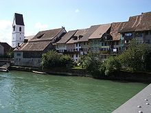
View of Mellingen |
|
| Location of the municipality | |
Mellingen ( Swiss German : ˈmɛliɡə ) is a municipality in the Swiss canton of Aargau . The small town belongs to the Baden district and is halfway between Baden and Lenzburg on the Reuss .
geography
The town is on the left side of the Reuss , which flows here from the southeast to the northwest. The overbuilt area is developed a in a plane on the west by the once from the Reuss glacier created terminal moraine of Wohlenschwil , on the south by the Wagenrain is limited and in the northeast by gently sloping, wooded hills. In the northwest, the Reuss flows through a gorge around 100 meters wide and 40 meters deep.
The area of the municipality is 487 hectares , of which 152 hectares are forested and 149 hectares are built over. The highest point is at 445 meters in the Schneeschmelzi (Brand) area, around two kilometers east-northeast of the center, the lowest at 344 meters on the Reuss. Neighboring communities are Birmenstorf in the northwest, Fislisbach in the north, Niederrohrdorf in the east, Stetten in the southeast, Tägerig in the south and Wohlenschwil in the west. In the north, Mellingen also borders the Rütihof exclave of the municipality of Baden .
history

There are numerous sites from the Mesolithic and Neolithic times in the municipality . The village settlement of Mellingen dates from the Alemannic period, the church of which was first mentioned in a document in 1045. The village was not identical to today's town. It was on the right bank of the Reuss and was also called Trostburger Twing in the High Middle Ages . The place name comes from the Old High German Mellingun and means "among the people of Mello". The name Menelingen was in use in the late Middle Ages .
The village first belonged to the Counts of Lenzburg , until it finally came into the possession of the Counts of Kyburg through inheritance . Around 1230, the Kyburgers founded the actual town of Mellingen on the left bank of the Reuss and had a ring wall built. There has been a bridge over the river since at least 1253. The Habsburgs , who had become rulers in 1273, granted Mellingen the same town charter as Winterthur in 1296 , whereupon they ordered a German-language copy of the town charter there. In 1364 the city acquired lower jurisdiction over the Trostburger Zwing , and in 1400 also blood jurisdiction .
In 1415 the confederates conquered Aargau. Mellingen was now part of the county of Baden , but was able to maintain its market rights and its judicial autonomy. In 1512 the city received from Pope Julius II a valuable Julius banner for the services rendered in the Great Pavier Campaign in 1508–1510 to expel the French. The city had to deliver the tithe to the Königsfelden monastery , the twing to the Agnesspital in Baden . Mellingen had the lower jurisdiction over Stetten (1415–1494) and Tägerig (1543–1798). On September 1st, 1505 a big fire raged, which destroyed almost all buildings.
The Catholic Mellingen was the most important bridgehead between the Reformed cities of Bern and Zurich . It was therefore the scene of numerous religiously motivated fighting. Between 1528 and 1712 the town was occupied by troops no less than twelve times, for example before the decisive battle in the Swiss Peasants' War of 1653. The rebellious peasants capitulated at Wohlenschwil at the gates of the city and had to accept harsh conditions in the Mellingen Peace. After the Second Villmerger War of 1712, Mellingen came under the rule of the Reformed towns of Zurich, Bern and Glarus .
In March 1798 the French took Switzerland and proclaimed the Helvetic Republic . Mellingen had to give up its special position and belonged to the short-lived canton of Baden . Only then did the Trostburger Twing finally become an integral part of Mellingen. The community has belonged to the canton of Aargau since 1803. Mellingen was heavily involved in the construction of the national railway . The Zofingen – Wettingen railway with the Reuss Bridge was opened on September 6, 1877 , but the company went bankrupt just a year later. To settle the debts, the entire forest of the local community had to be sold to the canton.
By 1900 disappeared because of phylloxera of the Middle Ages flourishing epidemic viticulture completely. Around the same time, the first industrial companies settled here . In the 1960s, the largest petrol and oil tank storage facility in Switzerland was built next to the train station. In the same decade the town had its greatest growth phase when the population increased by more than two thirds. On May 22, 1975 the opening of the Heitersberg tunnel to Killwangen took place .
Attractions
The center of Mellingen is the medieval old town. Its ground plan corresponds approximately to an isosceles triangle that stretches along the left bank of the Reuss. The short main street between Lindenplatz and Reussbrücke divides the old town in its middle. Two parallel streets run along the longitudinal axis. The city walls were left to decay in the 18th century and their remains were finally torn down.
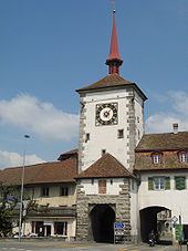
The time tower rises above the Lenzburgertor at the obtuse corner of the city plan. Clocks can be found on both facades of the tower, which has a slender roof turret, with the dial facing the main street being particularly richly decorated. The Lenzburgertor is the only gate in the canton of Aargau where the outwork has been preserved. The cylindrical round tower at the northwest end of the old town (also known as the witch's tower ) once served to defend the northern foreland. In 1902 it burned down and was then repaired.

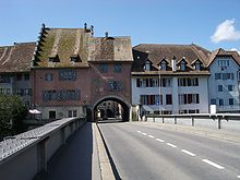
The first bridge, mentioned in 1253, was followed by several new buildings. A pillarless wooden bridge built in 1794 was replaced by a simple iron construction in 1928. You can get to the bridge from Hauptgasse through the bridge gate (also known as the Great Gate). It is flanked by the former town hall and an inn. The core of the town hall dates back to the 12th century. The municipal administration has not used the building since 1856, the furnishings in the late Gothic council chamber were removed in 1889 and can now be seen in the Swiss National Museum . In 2012, as part of a renovation of the old building, an ancient wall painting with the name «Solomon's Judgment» from the 16th century was discovered and secured. At the southeast corner of the old town is the Iberghof , a fortified building with an attached round tower.
Facing the Iberghof is the Catholic town church , which should have existed as early as the 10th century. The current baroque church building was built in 1675/76. The church tower from the 13th or 14th century has been preserved, but has been free-standing since then and is not directly connected to the rest of the building. The interior was carried across the 19th century neoclassical redesigned. The Catholic Antonius Chapel and the Reformed Church are located at the junction of Lenzburgerstrasse and Bremgarterstrasse, right by the cemetery.
coat of arms

The blazon of the municipal coat of arms reads: "Under a red-white-red shield head in yellow, a rising red lion." The town seal of 1293 was the first to combine the Habsburg and Austrian coats of arms. But this coat of arms was not used for centuries. Instead, a red ball in white has been handed down from the early 14th century, the colors appeared reversed from 1512. At the same time, the hamlet of Mellingen-Dorf on the right bank of the Reuss had a silver-white boar's head on a black background as its coat of arms. In 1935 the municipal council decided to use the older coat of arms.
population
The population developed as follows:
| year | 1600 | 1755 | 1803 | 1850 | 1900 | 1930 | 1950 | 1960 | 1970 | 1980 | 1990 | 2000 | 2010 |
| Residents | about 400 | 325 | 586 | 746 | 899 | 1538 | 1634 | 1941 | 3211 | 3285 | 3827 | 4239 | 4659 |
On December 31, 2019, 5773 people lived in Mellingen, the proportion of foreigners was 34%. In the 2015 census, 35.5% described themselves as Roman Catholic and 18.1% as Reformed ; 46.4% were non-denominational or of other faiths. In the 2000 census, 83.0% said their main language was German , 4.9% Italian , 2.6% Albanian , 2.1% Serbo-Croatian , 1.1% Turkish , 0.8% French and 0.7% Portuguese .
Politics and law
The assembly of those entitled to vote, the municipal assembly , exercises legislative power. The executing authority is the five-member municipal council . He is elected by the people in the majority procedure, his term of office is four years. The parish council leads and represents the parish. To this end, it implements the resolutions of the municipal assembly and the tasks assigned to it by the canton. The Baden District Court is responsible for litigation in the first instance . Mellingen is the seat of Friedensrichterkreis V, which includes 13 communities in the south of the district.
economy
According to the company structure statistics (STATENT) collected in 2015, there are around 1700 jobs in Mellingen, of which 1% in agriculture, 26% in industry and 73% in the service sector. Many employees are commuters and work in the city of Baden and the Limmat Valley west of Zurich , among other places . The Socar tank farm in Mellingen is on the Lenzburg – Wettingen railway line .
After the traditional viticulture had disappeared for over a century, a vineyard was re-established in 2013 . In 2018, an area of 1.5 hectares was planted with vines on a southern slope east of Mellingen. The varieties Blauburgunder , Pinotage , Riesling × Sylvaner and Sauvignon Blanc are grown .
traffic
Mellingen is located on Kantonsstrasse 268 between Lenzburg and Baden and is the starting point for Kantonsstrasse 269 to Brugg and Kantonsstrasse 270 to Bremgarten . The A1 motorway is around five kilometers away.
Already in 2011 a vote was taken on a bypass of Mellingen in order to free the old town from through traffic. After various objections, u. a. by VCS and WWF , the project was adapted several times. After all objections have been clarified, the groundbreaking will take place on June 6, 2020. The bypass leads west of the village and is divided into two sections, the 1st section leads from the tank farm roundabout over the Reuss to Birrfeldstrasse, the 2nd section from Birrfeldstrasse to Lenzburgerstrasse.
Mellingen Heitersberg station on the main Lenzburg – Zurich railway line has been in operation since December 12, 2004 , and trains from the Zurich S-Bahn stop every hour . It replaced the old Mellingen station on the Lenzburg – Wettingen line of the former national railway , which today is only used by freight trains. In addition, Mellingen is made accessible by post bus lines to Baden , Brugg , Bremgarten, Dättwil , Mägenwil and Wohlen . On weekends there is a night bus from Baden to Bremgarten.
media
The official publication organ of the municipality of Mellingen is the "Reussbote", first published in 1899. The local newspaper for the lower Reuss valley, the Rohrdorferberg and neighboring communities, which appears twice a week, is printed by the Mellinger printing house Nüssli.
education
There are three kindergarten locations (Weihermatt, Trottenstrasse and Neugrüen) and two school locations (Bahnhofstrasse and Kleine Kreuzzelg) where all levels of the compulsory elementary school are taught ( primary school , secondary school , secondary school and district school ). The closest grammar schools are the Baden Cantonal School and the Wettingen Cantonal School .
Personalities
- Eugen Lüthy (1927–1990), Chief of Staff
- Ulrich Meyer (1647–1694), Abbot of Wettingen
- Johann Jodok Singisen (1557–1644), abbot of Muri
literature
- Rainer Stöckli: Mellingen. In: Historical Lexicon of Switzerland .
- Peter Hoegger: The art monuments of the canton of Aargau . Ed .: Society for Swiss Art History . Volume VI: District of Baden I. Birkhäuser Verlag, Basel 1976, ISBN 3-7643-0782-X .
Web links
Individual evidence
- ↑ Cantonal population statistics 2019. Department of Finance and Resources, Statistics Aargau, March 30, 2020, accessed on April 2, 2019 .
- ↑ Cantonal population statistics 2019. Department of Finance and Resources, Statistics Aargau, March 30, 2020, accessed on April 2, 2019 .
- ↑ a b Beat Zehnder: The community names of the canton of Aargau . In: Historical Society of the Canton of Aargau (Ed.): Argovia . tape 100 . Verlag Sauerländer, Aarau 1991, ISBN 3-7941-3122-3 , p. 268 .
- ^ National map of Switzerland, sheet 1090, Swisstopo.
- ↑ Standard area statistics - municipalities according to 4 main areas. Federal Statistical Office , November 26, 2018, accessed on June 1, 2019 .
- ↑ Winfried Hecht: The Julius banner of the town facing Rottweil. In: Der Geschichtsfreund: Messages from the Central Switzerland Historical Association . 126/7 (1973/4). doi : 10.5169 / seals-118647
- ↑ Hoegger: The monuments of the Canton of Aargau. Pp. 385 and 389-390.
- ↑ Hoegger: The monuments of the Canton of Aargau. Pp. 391-394.
- ↑ Hoegger: The monuments of the Canton of Aargau. Pp. 394-395.
- ↑ Hoegger: The monuments of the Canton of Aargau. Pp. 395-397.
- ↑ Hoegger: The monuments of the Canton of Aargau. Pp. 421-424
- ↑ The "Solomon judgment" was secured. Reussbote, November 20, 2013, accessed on July 29, 2015 .
- ↑ Hoegger: The monuments of the Canton of Aargau. Pp. 424-428.
- ↑ Hoegger: The monuments of the Canton of Aargau. Pp. 399-414.
- ^ Joseph Galliker, Marcel Giger: Municipal coat of arms of the Canton of Aargau . Lehrmittelverlag des Kantons Aargau, book 2004, ISBN 3-906738-07-8 , p. 211 .
- ↑ Population development in the municipalities of the Canton of Aargau since 1850. (Excel) In: Eidg. Volkszählung 2000. Statistics Aargau, 2001, archived from the original on October 8, 2018 ; accessed on June 1, 2019 .
- ↑ Resident population by religious affiliation, 2015. (Excel) In: Population and Households, Community Tables 2015. Statistics Aargau, accessed on June 1, 2019 .
- ↑ Swiss Federal Census 2000: Economic resident population by main language as well as by districts and municipalities. (Excel) Statistics Aargau, archived from the original on August 10, 2018 ; accessed on June 1, 2019 .
- ↑ circles of justice of the peace. Canton of Aargau, accessed on June 19, 2019 .
- ↑ Statistics of the corporate structure (STATENT). (Excel, 157 kB) Statistics Aargau, 2016, accessed on June 1, 2019 .
- ↑ Carolin Frei: The first wine will be served in three years. Aargauer Zeitung , June 18, 2013, accessed on June 19, 2019 .
- ↑ Grape harvest control 2018 Canton Aargau. (PDF, 2.4 MB) Agricultural Center Liebegg, 2019, accessed on June 19, 2019 .
- ↑ Clear commitment to mobility. Canton of Aargau, May 15, 2011, accessed on April 2, 2020 .
- ↑ Mellingen - bypass. Canton of Aargau, accessed on April 2, 2020 .
- ↑ Geographical map of the bypass. Canton of Aargau, accessed on April 2, 2020 .
- ↑ Reussbote


